Overview
An upper level trough brought snow to mainly the southern half of central Indiana during the afternoon and evening of January 27. Most of the southern half of the area received 1" to 3" of snow, but there were isolated higher amounts.Snow/Ice
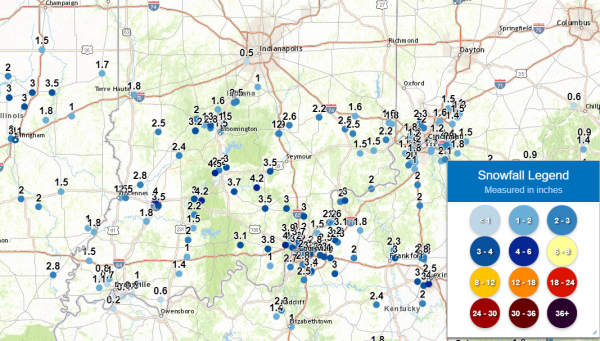
Maps of the snowfall reports receive are below. Please note that they may not match your location exactly. A text listing of reports received by county follow the maps.

Map of Snowfall Reports (24 hours ending 7 AM EST January 28).

Plot of Individual Snowfall Reports
List of Reports by County:
Public Information Statement
National Weather Service Indianapolis IN
956 AM EST Thu Jan 28 2021

...SNOWFALL REPORTS FROM 1/27/21 EVENT...

Location                     Amount    Time/Date       Provider

...Indiana...

...Bartholomew County...
3 ENE Columbus               2.6 in    0740 PM 01/27   Cocorahs
Columbus 3.6 SW              2.0 in    0700 AM 01/28   COCORAHS
Hope 5.2 NW                  1.5 in    0615 AM 01/28   COCORAHS
Columbus 1.9 NNE             1.5 in    0600 AM 01/28   COCORAHS

...Brown County...
Nashville 7.8 SE             1.9 in    0611 AM 01/28   COCORAHS

...Clay County...
Jasonville 4.0 ENE           2.5 in    0543 AM 01/28   COCORAHS

...Daviess County...
Washington                   4.0 in    0806 PM 01/27   Public
Washington 1.5 NW            3.9 in    0700 AM 01/28   COCORAHS
Washington 3.3 SE            3.5 in    0700 AM 01/28   COCORAHS

...Decatur County...
(KB9CIY)Greensburg 6.0 SW    2.2 in    0700 AM 01/28   COCORAHS
0.6 NW Greensburg            1.8 in    1200 AM 01/28   COOP

...Greene County...
Springville 6.0 W            3.0 in    0630 AM 01/28   COCORAHS
2 S Bloomfield               2.4 in    0900 PM 01/27   Public

...Jackson County...
Brownstown                   3.5 in    0815 AM 01/28   Emergency Mngr

...Johnson County...
Bargersville                 1.0 in    0700 PM 01/27   Trained Spotter

...Knox County...
Bicknell 0.5 W               2.8 in    0700 AM 01/28   COCORAHS
3 E Vincennes                2.5 in    0547 PM 01/27   CO-OP Observer
Vincennes                    1.5 in    0425 PM 01/27   Emergency Mngr

...Lawrence County...
3 SW Avoca                   4.5 in    0750 PM 01/27   Public
Mitchell 4.1 E               3.7 in    0730 AM 01/28   COCORAHS
Bedford 3.7 N                3.0 in    0700 AM 01/28   COCORAHS
1.7 S Avoca                  2.2 in    0700 AM 01/28   COOP

...Martin County...
Shoals 4.0 E                 4.2 in    0700 AM 01/28   COCORAHS
Shoals                       3.0 in    0612 PM 01/27   Public
Shoals 8 S                   2.2 in    0700 AM 01/28   COOP

...Monroe County...
(KC9RPX)Ellettsville 0.5 W   3.0 in    0700 AM 01/28   COCORAHS
Bloomington 6.5 WNW          2.8 in    0800 AM 01/28   COCORAHS
Bloomington 7.1 E            1.8 in    0800 AM 01/28   COCORAHS
4 W Unionville               1.5 in    0627 PM 01/27   Public
1 N Indiana University       1.5 in    0606 PM 01/27   Public
5 W Unionville               1.0 in    0500 PM 01/27   Public

...Morgan County...
2 ESE Martinsville           2.5 in    0545 PM 01/27   Public
3 S Paragon                  1.6 in    0515 PM 01/27   Public
(N9JPX)Paragon 3.2 ENE       1.5 in    0700 AM 01/28   COCORAHS
2.1 SW Martinsville          1.4 in    0700 AM 01/28   COOP
Mooresville 3.8 NE           1.0 in    0700 AM 01/28   COCORAHS
Brooklyn 0.5 ENE             1.0 in    0655 AM 01/28   COCORAHS

...Owen County...
Spencer 7.0 S                3.2 in    0500 AM 01/28   COCORAHS
Spencer                      2.0 in    0700 AM 01/28   COOP
4 W Ellettsville             1.0 in    0400 PM 01/27   Cocorahs

...Putnam County...
Cloverdale 3.5 W             1.3 in    0700 AM 01/28   COCORAHS

...Vigo County...
1 SSE Terre Haute            1.8 in    0700 PM 01/27   Trained Spotter
Terre Haute 6.1 ESE          1.5 in    0821 AM 01/28   COCORAHS
Terre Haute 6.5 N            1.0 in    0600 AM 01/28   COCORAHS

Observations are collected from a variety of sources with varying
equipment and exposures. We thank all volunteer weather observers
for their dedication. Not all data listed are considered official.
Environment
An upper level trough, an upper level jet, and a surface trough provided forcing that brought the snow to central Indiana.
 |
 |
 |
| Figure 1: 500mb Heights/700mb-400mb Vorticity Advection at 4:00 PM EST. | Figure 2: 300mb Height, Wind Speed, and Divergence at 4:00 PM EST | Figure 3: Surface Pressure/Wind at 4:00 PM EST |
 |
Media use of NWS Web News Stories is encouraged! Please acknowledge the NWS as the source of any news information accessed from this site. |
 |