Overview
An area of low pressure along with an upper trough brought snow to central Indiana on January 5 and 6th. Some sleet and freezing rain fell at times in portions of southern central Indiana. Snowfall amounts up to around a foot fell in parts of the area, with far northern areas not seeing much if any snow.Snow/Ice
Snow up to around a foot fell in some locations of southern central Indiana. Across the north, values quickly lowered to little or no snow in the far north.
A map of snowfall reports received by NWS Indianapolis is below, followed by a text listing. Please note that map may not match amounts received at your location. Thanks to everyone who sent in observations!
Public Information Statement
National Weather Service Indianapolis IN
413 PM EST Tue Jan 7 2025


...STORM TOTAL SNOWFALL from 4AM EST 1/5 -to- 1PM EST 1/6...

I. GREATEST REPORTS for each COUNTY...

 County       Location                Snowfall  Source
 JENNINGS     North Vernon             13.0 in  Public
 JACKSON      Seymour 0.6 SSW          12.5 in  CoCoRaHS
 DAVIESS      Elnora                   12.0 in  COOP
 DECATUR      Westport                 12.0 in  Public
 MORGAN       Martinsville             11.3 in  Public
 HENDRICKS    Brownsburg               11.0 in  Public
 BARTHOLOMEW  Columbus 4 SW            10.8 in  Public
 BROWN        Stone Head 2.3 ENE       10.5 in  CoCoRaHS
 MONROE       Bloomington 2.7 E        10.4 in  CoCoRaHS
 MARION       Lawrence                 10.0 in  Public
 MARION       Nora 0.9 E               10.0 in  CoCoRaHS
 VERMILLION   Clinton                  10.0 in  Public
--------------------------------------------------------------
 KNOX         Bicknell                  9.8 in  Spotter
 LAWRENCE     Avoca 3 NNW               9.8 in  Amateur Radio
 SHELBY       Shelbyville               9.8 in  Public
 HAMILTON     Nora 2.1 N                9.5 in  CoCoRaHS
 OWEN         Spencer                   9.5 in  Public
 PUTNAM       Greencastle               9.5 in  Public
 PARKE        Rockville 0.6 NNE         9.1 in  CoCoRaHS
 RUSH         Rushville                 9.0 in  COOP
 BOONE        Whitestown                8.5 in  Public
 GREENE       Bloomfield                8.3 in  CoCoRaHS
 HANCOCK      Fortville                 8.2 in  Public
 SULLIVAN     Carlisle                  8.0 in  Public
 HENRY        New Castle 3 SW           7.8 in  COOP
 MADISON      Ingalls 3.0 WNW           7.8 in  CoCoRaHS
 VIGO         Terre Haute 2 NE          7.8 in  Public
 MARTIN       Shoals 5 E                7.5 in  Amateur Radio
 MONTGOMERY   Ladoga                    7.5 in  Public
 CLAY         Clay City                 6.2 in  CoCoRaHS
 FOUNTAIN     Wallace                   6.0 in  Public
--------------------------------------------------------------
 RANDOLPH     Modoc                     4.0 in  CoCoRaHS
 TIPTON       Tipton 5 SW               3.1 in  COOP
 CLINTON      Kirlin 3.7 W              2.6 in  CoCoRaHS
 TIPPECANOE   Lafayette 8 S             0.9 in  COOP
 HOWARD       Kokomo 3 WSW              0.2 in  COOP
 WARREN       Pence 1 SW                0.1 in  COOP
 CARROLL      Flora 0.6 E                 T in  CoCoRaHS


II. 33-HOUR STORM TOTAL SNOWFALL REPORTS, by county...

Central Indiana location        Amount  Time/Date  Provider

...Bartholomew County...
Columbus 4 SW                  10.8 in  1230P 1/6  Public
Taylorsville 0.8 SSW           10.0 in   430A 1/6  CoCoRaHS
Columbus                        9.8 in  1245P 1/6  Public
Hope                            9.0 in  1226P 1/6  Public
Columbus 1.7 N                  8.3 in   700A 1/7  CoCoRaHS
Columbus WWTP                   7.9 in   700A 1/7  COOP
Flat Rock 1.2 SSW               7.0 in   700A 1/7  CoCoRaHS

...Boone County...
Whitestown                      8.5 in   948A 1/6  Public
Zionsville                      8.3 in   600A 1/6  CoCoRaHS
Whitestown 5 NE                 8.0 in   552A 1/6  Public
Lebanon 6 W                     3.1 in   700A 1/7  COOP
Thorntown 3.4 SW                1.5 in   700A 1/7  CoCoRaHS

...Brown County...
Stone Head 2.3 ENE             10.5 in   700A 1/7  CoCoRaHS
Beanblossom 1.4 NE (W9DBA)      8.0 in   700A 1/7  CoCoRaHS
Needmore 1.7 SSW                6.8 in   700A 1/7  CoCoRaHS

...Carroll County...
Flora 0.6 E                       T in   700A 1/6  CoCoRaHS

...Clay County...
Clay City                       6.2 in   900A 1/7  CoCoRaHS
Brazil 1 S                      6.0 in   830A 1/7  COOP
Howesville                      5.7 in   700A 1/7  CoCoRaHS
Cobb 1.5 SE                     5.3 in   700A 1/7  CoCoRaHS

...Clinton County...
Kirlin 3.7 W                    2.6 in   700A 1/7  CoCoRaHS
Frankfort 0.9 SSE               1.2 in   700A 1/7  CoCoRaHS
Frankfort Disposal              1.0 in   900A 1/7  COOP
Mulberry 0.6 SSE                0.4 in   700A 1/7  CoCoRaHS

...Daviess County...
Elnora                         12.0 in   400P 1/6  COOP
Washington 1 W                  9.4 in   600P 1/6  COOP
Plainville 1.3 S                9.0 in   700A 1/7  CoCoRaHS
Washington 1.5 NW               8.2 in   700A 1/7  CoCoRaHS

...Decatur County...
Westport                       12.0 in  1117A 1/6  Public
Lake Santee 1 NW               10.1 in  1054A 1/6  Spotter
Greensburg                     10.0 in  1213P 1/6  EMA

...Delaware County...
Muncie                          3.0 in   700A 1/7  COOP

...Fountain County...
Wallace                         6.0 in   404P 1/6  Public
Covington                       2.0 in   700A 1/6  CoCoRaHS

...Greene County...
Bloomfield                      8.3 in   700A 1/6  CoCoRaHS
Owensburg 1.0 N                 6.8 in   700A 1/7  CoCoRaHS

...Hamilton County...
Nora 2.1 N                      9.5 in  1220P 1/6  Public
McCordsville 2.6 NE             9.0 in   700A 1/7  CoCoRaHS
Carmel 1.5 W                    8.5 in   700A 1/7  CoCoRaHS
Geist Park                      8.3 in  1200P 1/6  NWS Employee
Fishers                         8.0 in  1228P 1/6  Public
Fishers 4.3 ENE                 8.0 in   700A 1/7  CoCoRaHS
Carmel 1.7 SSE                  7.8 in  1145A 1/6  Public
Noblesville 4.4 ESE             7.0 in   700A 1/7  CoCoRaHS
Westfield 2 NW                  6.3 in   835A 1/6  NWS Employee
Westfield 1.4 ESE               6.3 in   700A 1/7  CoCoRaHS
Noblesville                     6.0 in  1224P 1/6  Public
Strawtown 2.2 E                 4.0 in   700A 1/7  CoCoRaHS
Sheridan                        2.5 in   700A 1/7  CoCoRaHS

...Hancock County...
Cumberland 0.3 E                8.2 in  1227P 1/6  Public
Fortville                       8.2 in  1253P 1/7  Public
Wilkinson                       8.1 in  1244P 1/6  Public
Greenfield Water                7.5 in   800A 1/7  COOP

...Hendricks County...
Brownsburg                     11.0 in  1208P 1/6  Public
Brownsburg 5.1 NNE             10.3 in   700A 1/7  CoCoRaHS
Avon 0.8 N                      9.1 in   600A 1/6  CoCoRaHS
Avon 1 NE                       8.6 in   230P 1/6  NWS Employee
Danville 3 SW                   8.6 in   700A 1/7  COOP
Avon 1.4 SSW                    7.9 in   700A 1/7  CoCoRaHS

...Henry County...
New Castle 3 SW                 7.8 in   700A 1/7  COOP
New Castle                      7.4 in   105P 1/6  Public

...Howard County...
Kokomo 3 WSW                    0.2 in   700A 1/6  COOP
Young America                     T in   800A 1/6  COOP
Center 1.3 NNE                    T in   700A 1/7  CoCoRaHS

...Jackson County...
Seymour 0.6 SSW                12.5 in   800A 1/6  CoCoRaHS
Freetown                        9.0 in  1200P 1/6  Public

...Jennings County...
North Vernon                   13.0 in  1058A 1/6  Public
North Vernon 2 ESE             11.9 in   500P 1/6  COOP

...Johnson County...
Franklin 2.0 NW                 9.3 in   700A 1/7  CoCoRaHS
Greenwood 0.6 ESE               9.0 in   700A 1/7  CoCoRaHS
Bargersville 2 S                9.0 in   210P 1/6  Public
Whiteland                       9.0 in  1052A 1/6  Public
Franklin 4.4 S                  8.3 in   800A 1/7  CoCoRaHS
Stones Crossing 1.1 SW          8.2 in   800A 1/7  CoCoRaHS
Smith Valley 0.9 NE             7.9 in   700A 1/7  CoCoRaHS
Franklin 1 W                    7.6 in   700A 1/7  NWS Employee

...Knox County...
Bicknell                        9.8 in  1130A 1/6  Spotter
Vincennes                       7.0 in   931A 1/6  Public
Vincennes 5 NE                  6.5 in   800A 1/7  COOP

...Lawrence County...
Avoca 3 NNW                     9.8 in  1032A 1/6  Amateur Radio
Oolitic Purdue Ex Farm          7.9 in   700A 1/7  COOP
Mitchell 4.1 E                  7.8 in   700A 1/7  CoCoRaHS
Williams Dam                    7.3 in   700A 1/7  COOP
Bedford 3.7 N                   7.0 in   700A 1/7  CoCoRaHS
Oolitic                         6.1 in   206P 1/6  Public

...Madison County...
Ingalls 3.0 WNW                 7.8 in   700A 1/7  CoCoRaHS
Summitville                     6.0 in   700A 1/6  Public
Anderson 4.0 N                  5.8 in  1030A 1/7  CoCoRaHS
Anderson 0.4 ESE                5.7 in   700A 1/7  CoCoRaHS
Anderson 1 N                    4.2 in   800A 1/7  COOP

...Marion County...
Lawrence                       10.0 in   306P 1/6  Public
Nora 0.9 E                     10.0 in   700A 1/7  CoCoRaHS
Camby                           9.5 in   101P 1/6  Public
Eagle Creek Reservoir 3 NE      9.4 in  1051A 1/6  Media
Clermont                        9.0 in   130P 1/6  Public
Homecroft                       8.7 in  1245P 1/6  NWS Employee
McCordsville 1.3 W              8.4 in   700A 1/7  CoCoRaHS
Castleton 2 S                   8.2 in  1159P 1/6  COOP
Holy Cross                      8.0 in  1225P 1/6  NWS Employee
Speedway                        8.0 in   800A 1/6  CoCoRaHS
Indianapolis Intl Airport 1.1 S 7.8 in   100P 1/6  NWS WFO
Irvington                       7.8 in   700A 1/7  CoCoRaHS
Fountain Square 1.6 SSW         7.8 in   700A 1/6  CoCoRaHS

...Martin County...
Shoals 5 E                      7.5 in   900A 1/6  Amateur Radio
Williams 3 SW                   7.1 in   700A 1/7  COOP
Shoals 8 S                      7.0 in   700A 1/7  COOP

...Monroe County...
Bloomington 2.7 E              10.4 in   700A 1/7  CoCoRaHS
Ellettsville 0.5 W (KC9RPX)     9.0 in   700A 1/7  CoCoRaHS
Bloomington 4.3 NW              8.5 in   700A 1/7  CoCoRaHS
Unionville 3.4 SSE              8.3 in   700A 1/7  CoCoRaHS
Unionville                      7.8 in   700A 1/7  CoCoRaHS

...Montgomery County...
Ladoga                          7.5 in   144P 1/6  Public
Crawfordsville 6 SE             5.7 in   600A 1/7  COOP
Crawfordsville                  4.0 in   252P 1/6  Public

...Morgan County...
Martinsville                   11.3 in  1202P 1/6  Public
Martinsville 2 SW              10.5 in   700A 1/7  COOP
Martinsville 3.9 ESE            9.3 in   700A 1/7  CoCoRaHS
Brooklyn                        9.0 in  1203P 1/6  Public
Monrovia 1 N                    8.5 in  1220P 1/6  NWS Employee
Mooresville 3 NE                7.9 in   100P 1/6  CoCoRaHS
Paragon 3.2 ENE (N9JPX)         7.5 in   700A 1/7  CoCoRaHS

...Owen County...
Spencer                         9.5 in  1215P 1/6  Public
Freeman 2.4 WSW                 8.2 in   830A 1/6  CoCoRaHS
Spencer 5.7 SE                  8.0 in   700A 1/7  CoCoRaHS

...Parke County...
Rockville 0.6 NNE               9.1 in   700A 1/7  CoCoRaHS
Rockville 3 E                   8.7 in   315P 1/6  Public
Rockville Fire                  8.0 in   500P 1/6  COOP

...Putnam County...
Greencastle                     9.5 in  1000A 1/6  Public
Greencastle 3.6 ESE             9.0 in   700A 1/7  CoCoRaHS
Cloverdale 3.5 W                7.2 in   700A 1/7  CoCoRaHS

...Randolph County...
Modoc                           4.0 in   700A 1/6  CoCoRaHS
Farmland                        1.9 in   700A 1/7  CoCoRaHS
Farmland 5 NNW                  1.5 in   700A 1/7  COOP
Winchester 2.2 WSW (KC9FXU)     1.5 in   700A 1/7  CoCoRaHS

...Rush County...
Rushville                       9.0 in   700A 1/7  COOP
Rushville                       8.5 in  1216P 1/6  EMA
Homer                           7.0 in   700A 1/7  CoCoRaHS
Gwynneville 2.2 NNE             6.5 in   700A 1/7  CoCoRaHS

...Shelby County...
Shelbyville                     9.8 in  1000A 1/6  Public
Fairland 0.9 SSW                8.0 in   700A 1/7  CoCoRaHS
Morristown                      7.0 in   130P 1/6  Law Enforcement

...Sullivan County...
Carlisle                        8.0 in   259P 1/6  Public
Farmersburg TV-2                6.0 in  1159P 1/6  COOP
Graysville 5 WNW                5.3 in   800A 1/7  COOP
Hymera                          5.0 in   700A 1/7  CoCoRaHS

...Tippecanoe County...
Lafayette 8 S                   0.9 in   800A 1/7  COOP
West Lafayette 1.1 N            0.2 in   800A 1/6  CoCoRaHS
Lafayette 0.9 WSW                 T in   700A 1/7  CoCoRaHS

...Tipton County...
Tipton 5 SW                     3.1 in   700A 1/7  COOP

...Vermillion County...
Clinton                        10.0 in  1248P 1/6  Public
Newport                         6.0 in   700A 1/7  CoCoRaHS
Perrysville 4 WNW               2.3 in   600A 1/7  COOP

...Vigo County...
Terre Haute 2 NE                7.8 in   720A 1/6  Public
Terre Haute 2 S                 7.0 in   730A 1/6  Amateur Radio

...Warren County...
Pence 1 SW                      0.1 in   700A 1/6  COOP

Observations are collected from a variety of sources with varying
equipment and exposures. We thank all volunteer weather observers
for their dedication. Not all data listed are considered official.
Historical Perspective
The January 5-6, 2025 snowstorm...
 - Officially totaled 7.8" of snowfall at Indianapolis
 - Greatest 2-day snowfall in almost 4 years
 - 4th-greatest 2-day snowfall in exactly 11 years
 - Greatest 2-day *January* snowfall since 2014

////////////////////////////////////////////////////////////////

 Last Decade's Ten Greatest Indianapolis Snowstorms...
 (1/7/2015 - 1/6/2025)...By Descending Snowfall...

 1. 2018/MAR/24     10.2"
 2. 2021/FEB/15-16   8.1
 3. 2015/2/28-3/1    7.9
 4. 2025/JAN/5-6     7.8**
 5. 2022/FEB/2-3     7.6
 6. 2019/JAN/12-13   7.2
 7. 2019/DEC/15-16   6.8
 8. 2015/FEB/21-22   5.3
 9. 2021/JAN/30-31   4.2
10. 2024/FEB/16      3.9

////////////////////////////////////////////////////////////////

 Last Ten Indianapolis 2-Day Snowstorms Totaling 7.8"+
 (Since April 2000)...By Reverse Chronological Order...

 1. 2025/JAN/5-6     7.8"**
 2. 2021/FEB/15-16   8.1
 3. 2018/MAR/24     10.2
 4. 2015/2/28-3/1    7.9
 5. 2014/JAN/5-6    11.4
 6. 2013/MAR/24-25   9.1
 7. 2009/JAN/27-28  12.3
 8. 2007/FEB/13-14   8.1
 9. 2004/DEC/22-23  10.1
10. 2002/DEC/24-25   7.8

////////////////////////////////////////////////////////////////

 Last Ten Indianapolis 2-Day *January* Snowstorms Totaling 7.8"+
 (Since 1966)...By Reverse Chronological Order...

 1. 2025/JAN/5-6     7.8"**
 2. 2014/JAN/5-6    11.4
 3. 2009/JAN/27-28  12.3
 4. 1999/JAN/1-2     9.6
 5. 1994/JAN/16-17   7.9
 6. 1982/JAN/30-31   8.1
 7. 1978/JAN/25-26  15.2
 8. 1977/JAN/8-10    8.0
 9. 1969/JAN/6       9.2
10. 1968/JAN/13-14  11.1

////////////////////////////////////////////////////////////////

 Indianapolis Area 44 Greatest 2-Day Snowstorms On Record
 (Since March 1884)...By Descending Snowfall...

  1. 1910/JAN/16-17  16.1"
  2. 1978/JAN/25-26  15.2
  3. 1973/DEC/19-20  12.6
  4. 1965/FEB/24-25  12.5
 T5. 1906/MAR/19-20  12.3
 T5. 2009/JAN/27-28  12.3
  7. 1984/FEB/27-28  12.2
  8. 1996/MAR/19-20  11.6
 T9. 1973/DEC/30-31  11.4
 T9. 2014/JAN/5-6    11.4
 11. 1965/JAN/15-16  11.3
 12. 1968/JAN/13-14  11.1
 13. 1895/JAN/10-11  10.9
 14. 1912/FEB/21-22  10.3
 15. 2018/MAR/24     10.2
 16. 2004/DEC/22-23  10.1
T17. 1910/FEB/15-16  10.0
T17. 1895/DEC/30-31  10.0
T19. 1977/DEC/5-6     9.6
T19. 1999/JAN/1-2     9.6
 21. 1895/DEC/26      9.5
 22. 1969/JAN/6       9.2
T23. 1989/OCT/19-20   9.1
T23. 2013/MAR/24-25   9.1
 25. 1918/JAN/11-12   8.8
 26. 1932/NOV/16      8.6
 27. 1964/JAN/12-13   8.5
T28. 1966/NOV/2-3     8.3
T28. 1979/FEB/25-26   8.3
T30. 2000/MAR/11      8.1
T30. 2021/FEB/15-16   8.1
T30. 2007/FEB/13-14   8.1
T30. 1982/JAN/30-31   8.1
T34. 1918/JAN/14-15   8.0
T34. 1995/DEC/19-20   8.0
T34. 1977/JAN/9-10    8.0
T37. 1914/FEB/22-23   7.9
T37. 1927/JAN/13-14   7.9
T37. 2015/2/28-3/1    7.9
T37. 1981/DEC/16-17   7.9
T37. 1994/JAN/16-17   7.9
T42. 2025/JAN/5-6     7.8**  <---3.4-YEAR RETURN PERIOD
T42. 2002/DEC/24-25   7.8
T42. 1924/MAR/19-20   7.8
Environment
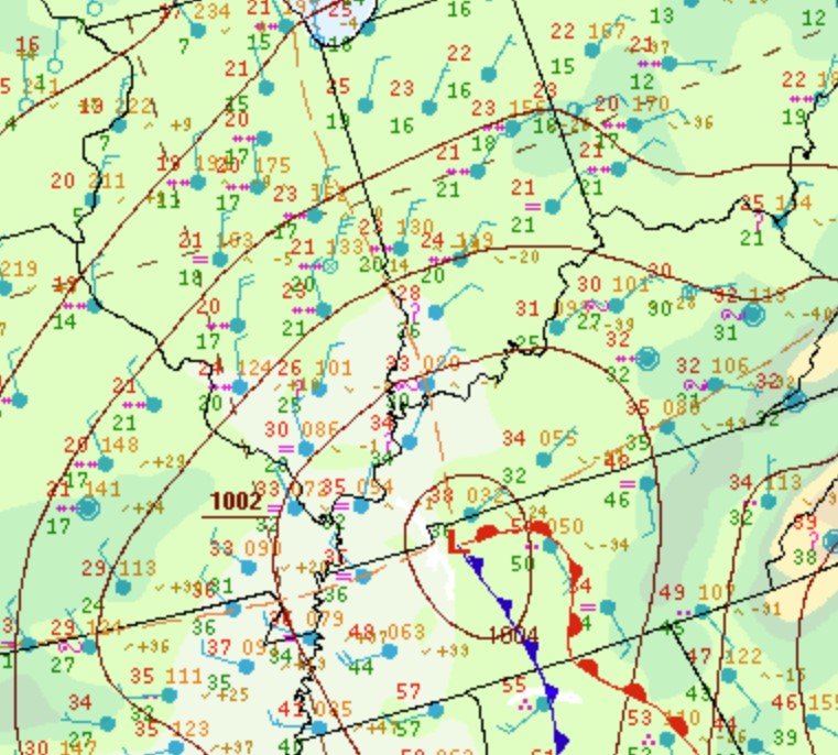
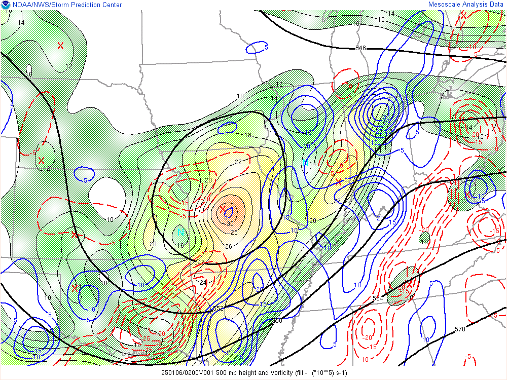
Strong forcing and plentiful moisture led to the snow and mixed precipitation across much of central Indiana. Very dry air across northern Indiana worked into northern portions of central Indiana, preventing much accumulation and creating a sharp gradient in snowfall amounts.
 |
 |
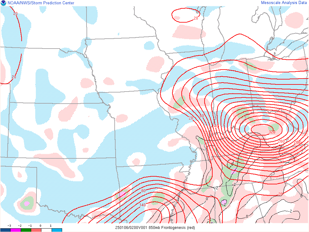 |
| Figure 1: Surface Map at 10pm EST Jan 5 | Figure 2: 500mb Heights and Vorticity at 9 PM EST | Figure 3: 850mb Frontogenesis at 9 PM EST |
Additional Information
The Forecast
 |
 |
 |
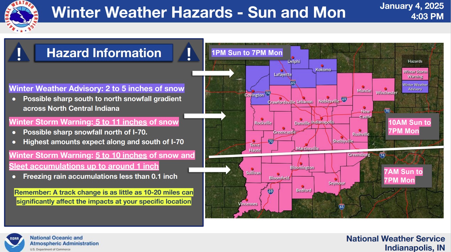 |
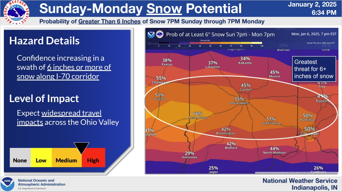
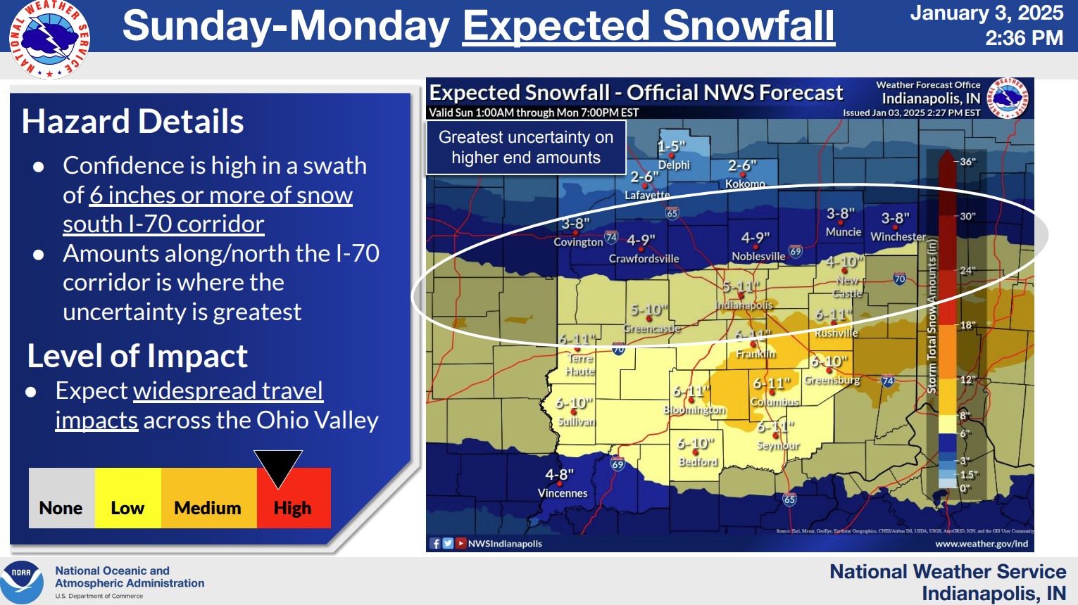
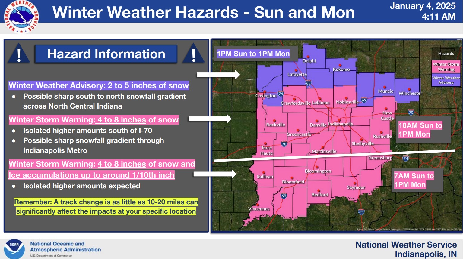
| Graphic Issued at 6:34 PM January 2 | Graphic Issued at 2:36 PM January 3 | Graphic Issued at 4:11 AM January 4 | Graphic Issued at 4:03 PM January 4 |
Although a sharp gradient was expected with this event across northern portions of central Indiana, the extent of very little snowfall was larger than expected. Elsewhere, amounts were often within or near expected ranges.
Summaries from other NWS Offices
 |
Media use of NWS Web News Stories is encouraged! Please acknowledge the NWS as the source of any news information accessed from this site. |
 |