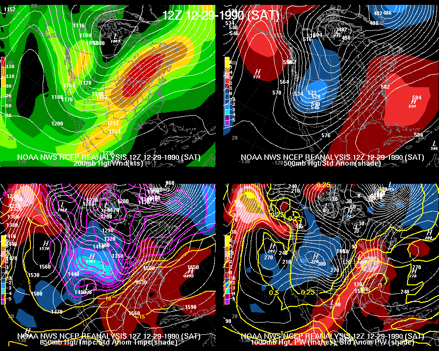
Atmospheric Setup on December 29, 1990. Click to enlarge.
A major flood occurred across much of Indiana during the end of December 1990 and beginning of January 1991. This page provides a summary of the event. Use the tabs on the page to view some climatology of the event or a detailed overview of the event.
| Location | Rainfall | Snowfall |
|---|---|---|
| Bloomington (at Indiana University) | 7.44" (fourth wettest December on record) | N/A |
| Columbus | 8.33" (was record for December at the time, now second wettest) | N/A |
| Lafayette (8 miles south) | 6.19" (was second wettest at the time, now third wettest) | 9.4" |
| Indianapolis | 7.72" (wettest December on record) | 9.6" |
| Muncie (at Ball State) | 9.51" (wettest December on record) | 11.5" |
| Terre Haute (at Indiana State) | 7.08" (second wettest December on record) | N/A |
 |
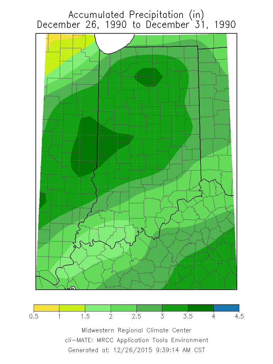 |
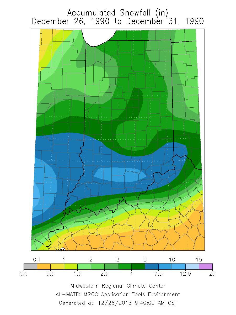
| Heavy snow fell on December 27, adding to existing snow cover and providing additional moisture. Click the map for a larger version. Map courtesy of the Midwestern Regional Climate Center. | Warm air then melted the snow, and heavy rain fell on top of the saturated and partially frozen ground. Click the map for a larger version. Map courtesy of the Midwestern Regional Climate Center. |
| River and Location | Crest and Remarks |
|---|---|
| White River at Anderson | 18.83 feet. (highest crest since 1964) |
| White River at Noblesville | 21.29 feet. (highest crest since 1964) |
| White River at Raymond St, Indianapolis | 20.51 feet. (highest crest since 1943) |
| White River near Centerton | 18.38 feet. (highest crest since 1913) |
| Wildcat Creek at Kokomo | 16.95 feet. (highest crest since 1959) |
| Big Blue River at Shelbyville | 18.03 feet. (highest crest since 1937) |
| Driftwood River Near Edinburgh | 16.20 feet. (highest crest since 1963) |
The following is an excerpt from a report on the event compiled by the NWS Indianapolis' Service Hydrologist.
A classic major flood event played out in much of the Indianapolis Hydrologic Service Area during the end of December 1990 and the first week of January 1991. Corps of Engineers estimated flood damage ranged from 50 to 100 million dollars. There were more than 2,000 homes and at least 4,000 people evacuated. A total of at least 4,000 homes and more than 10,000 people were touched by various aspects associated with flooding. Three people died as a result of flooding. Seventy-two out of 92 Indiana counties were declared disaster areas.
Above normal temperatures and rainfall had occurred through much of the first three weeks of December. Rises were noted on all streams.
Lowland flooding occurred along all major rivers in the state.
From December 22nd through the 24th, snow and sleet fell over the entire state. Snow depths ranged from 7 to 8 inches in northern Indiana with 3 to 4 inches in central and southern Indiana. A very cold outbreak of arctic air arrived Christmas Day. This provided Indiana with a White Christmas, but important to the coming flood event, froze the ground surface to a slight degree.
As the bitter arctic air started to retreat on the 26th, another storm system on the 27th dropped 6 to 8 inches of snow in southern Indiana, 3 to 5 inches in central Indiana and 1 to 2 inches in northern Indiana.
Total snow depths on the morning of the 28th ranged from 5 to 6 inches in northern and central Indiana and 4 to 10 inches in southern Indiana. Water equivalent of the snow ranged between 0.5 and 1.0 inch. Lowland flooding from an earlier rain event continued along the Wabash and White Rivers in southwest Indiana. The weather events of the next three days would produce flooding that had not been seen in some areas in more than 30 years.
Major warming occurred on the 28th and 29th as a very strong southwest jet stream at 18,000 feet brought sub-tropical air from the Gulf of America into Indiana. The lifting of this warm, moist air over the remnants of the arctic air and the cold, snow covered ground produced extensive fog late Friday night and Saturday morning. As the subtropical air reached the surface, temperatures rose into the 40s in northwest Indiana, 50s in central and northeast Indiana and the upper 50s to low 60s in southern Indiana.
The warm, moist subtropical air quickly melted the snow cover in northeast, central and southern Indiana by Saturday morning the 29th. Because the air was very moist, the snow did not evaporate. Instead the snow cover turned into 3/4 to 1 inch of liquid water. Because the underlying ground was saturated and in some areas partially frozen, this liquid water went into the streams.
The position of the southwest jet stream at 18,000 feet over Indiana was very favorable for continuous rain. This rain began early Saturday morning in northwest Indiana and gradually spread southward across central Indiana by Saturday evening. The rain continued Saturday night in central Indiana and spread into southern Indiana by Sunday morning. Rain continued in southern Indiana into early Sunday afternoon.
As the storm system passed, colder and drier air changed the rain to snow in northwest and north central Indiana Saturday night, in central Indiana by Sunday afternoon and in southern Indiana by Sunday night. Several inches of snow fell in northern Indiana with lesser amounts in central and southern Indiana. The cold temperatures would add drastically to the misery of the flooding.
Total rain from the storm system measured from less than 1 inch in extreme southwest Indiana to nearly 5 inches in portions of central Indiana. Much of the state received 3 to 4 inches of rain. Because the previous snow cover melted so quickly in southern, central and northeast Indiana, it effectively added 3/4 to nearly another 1 inch of liquid water to the storm event. This combination adds up to a total of 1 1/2 to 6 inches of rain available to flood the streams. Because of the flat terrain and the very cold air moving into northwest Indiana Saturday night, all of the snow did not melt in northwest Indiana and some of the rain that fell froze as ponded water. This reduced the flood event in the Kankakee River Basin to a certain degree.
Widespread flooding resulted [across much of Indiana]. Several rivers had near major to major flooding. The thoroughly saturated ground conditions, recent floods and partially frozen ground allowed the water no place to go except into the streams. The rapid melting snow started the streams flowing and the continuous rain of 24 to 36 hours allowed the small streams to feed the rivers for an extended period of time. As a result nearly every stream and river [across much of Indiana] flooded extensively.
The amount of rain that fell was the controlling factor for the severity of the flooding. Those areas receiving a total combination of rain and liquid water from melted snow of 3 1/2 to 5 inches flooded severely. Serious flooding occurred along the Kankakee, both Eels, Maumee, Wabash, Mississinewa, Salamonie, White, Whitewater, East Fork White and Muscatatuck Rivers. Numerous creeks and ditches overflowed extensively.
The characteristic feature of the drainage area of the state causes rivers in northern and central Indiana to flood first. Except for the Kanakakee River, flood crests are attained in about 1 to 3 days in central and northern Indiana. Because of the flatness of northwest Indiana, flood crests can take 7 or more days. Flood waters from central and northern Indiana spread southward along the Wabash, White and East Fork of White Rivers reaching southern Indiana in 5 to 10 days.
Because almost all of Indiana's flood plains are flat, the bitterly cold temperatures from December 31, 1990 to January 4, 1991 contributed greatly to the flood disaster and misery. The cold temperatures froze the flood waters and left ice several inches thick in homes and on roads. Those homes that were evacuated and had their heat turned off had frozen water pipes. Ice was so treacherous that some residents could not return to their homes. The hardest hit areas were Marion, Howard and Hamilton counties. Nearly 1,000 homes had first floor flooding. At least another 1,000 homes were affected or threatened by possible levee failures. Areas flooded in these counties included Ravenswood, Riverwood, Trails End, Noblesville, southwest Indianapolis and Kokomo. Evacuations in these areas probably exceeded 1,000 people.

