A strong area of low pressure moving quickly northeast into the Great Lakes on Saturday, November 5, 2022 produced wind gusts as high as 65 MPH across central Indiana. Below is a list of all observations greater than or equal to 45 MPH across the area on Saturday.
000
NOUS43 KIND 060038
PNSIND
INZ021-028>031-035>049-051>057-060>065-067>072-061238-

Public Information Statement
National Weather Service Indianapolis IN
838 PM EDT Sat Nov 5 2022

...HIGHEST WIND REPORTS...

Location                     Speed     Time/Date       Provider
Frankfort                    65 MPH    0420 PM 11/05   MESOWEST
W. Lafayette - Purdue Univ.  64 MPH    0339 PM 11/05   ASOS
0.7 S Loogootee (INDOT)      58 MPH    1050 AM 11/05   MESOWEST
Frankfort                    58 MPH    0935 AM 11/05   AWOS
Bloomington                  56 MPH    1106 AM 11/05   ASOS
Westfield                    55 MPH    0602 PM 11/05   CWOP
Terre Haute                  55 MPH    0336 PM 11/05   ASOS
Indianapolis                 54 MPH    0432 PM 11/05   ASOS
Muncie                       54 MPH    0415 PM 11/05   ASOS
Shelbyville                  53 MPH    0316 PM 11/05   ASOS
Noblesville                  52 MPH    0230 PM 11/05   CWOP
Bloomington                  51 MPH    0349 PM 11/05   CWOP
New Palestine                50 MPH    1145 AM 11/05   CWOP
3.3 N Lewisville (INDOT)     50 MPH    0110 PM 11/05   MESOWEST
Georgetown Road Over I-65    50 MPH    0420 PM 11/05   MESOWEST
Agronomy Center For Research 50 MPH    0430 PM 11/05   MESOWEST
US-31 At SR-32               49 MPH    0420 PM 11/05   MESOWEST
Indianapolis (Eagle Creek)   49 MPH    0340 PM 11/05   ASOS
Kokomo                       48 MPH    0406 PM 11/05   CWOP
Muncie                       48 MPH    0115 PM 11/05   CWOP
1.5 NE Whitehall (INDOT)     48 MPH    0310 PM 11/05   MESOWEST
3.2 NW Riley (INDOT)         48 MPH    0349 PM 11/05   MESOWEST
Crawfordsville               48 MPH    0435 PM 11/05   AWOS
Greencastle                  48 MPH    0955 AM 11/05   AWOS
Greenwood                    48 MPH    1155 AM 11/05   AWOS
1.4 SW Sullivan (INDOT)      47 MPH    0930 AM 11/05   MESOWEST
US-31 At SR-38               47 MPH    1049 AM 11/05   MESOWEST
Throckmorton Purdue Agricult 47 MPH    0430 PM 11/05   MESOWEST
Greencastle (WEATHERSTEM)    46 MPH    0110 PM 11/05   MESOWEST
Sharpsville                  46 MPH    0500 PM 11/05   CWOP
0.8 N Cloverdale (INDOT)     46 MPH    0429 PM 11/05   MESOWEST
1.4 NW Speedway (INDOT)      46 MPH    0240 PM 11/05   MESOWEST
Feldun Purdue Agricultural C 46 MPH    1130 AM 11/05   MESOWEST
Indianapolis Metro Airport   45 MPH    1155 AM 11/05   MESOWEST


Observations are collected from a variety of sources with varying
equipment and exposures. We thank all volunteer weather observers
for their dedication. Not all data listed are considered official.

$$
Below are surface analyses from the Weather Prediction Center at 11 AM, 2 PM, and 5 PM EDT depicting the strong low and cold front as it impacted the region. (Click images to enlarge.)
 |
 |
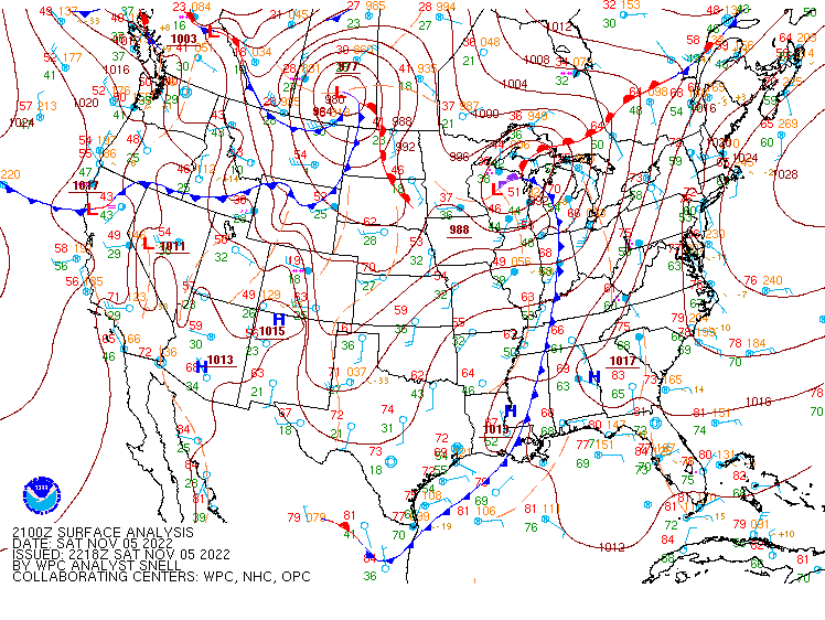 |
| 1500 UTC (11 AM EDT) Surface Analysis | 1800 UTC (2 PM EDT) Surface Analysis | 2100 UTC (5 PM EDT) Surface Analysis |

