Week 4: Forecasting Winter Storms
Forecasting winter storms across central Illinois can be very challenging. Numerous variables come into play when attempting to determine precise impacts days in advance of the system, with even small changes in these variables resulting in potentially large swings in the forecast. For example, a surface temperature change of just a couple of degrees can mean the difference between rain...or a major ice storm. So what exactly do NWS meteorologists look at when predicting winter storms? What issues and challenges do they face...and why do winter storm forecasts occasionally go awry? To answer these questions, let's first examine the primary meteorological variables that go into the winter storm forecasting process.
1) Low Track
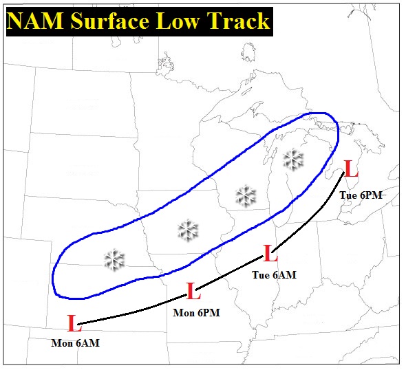
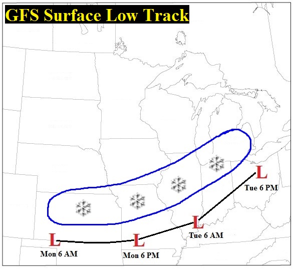
The first thing most meteorologists examine is the expected track of the surface low pressure system. Oftentimes forecasts are made before the system has even developed, making the process of projecting its eventual path even more challenging. In order to predict systems more than a day or two in advance, forecasters rely on a suite of computer models that ingest surface, upper air, satellite, radar, and various other meteorological data in order to formulate forecasts based on a set of complex atmospheric equations. There are numerous models available, all with slightly different inputs and physics built into them. Some of the more common models include the North American Mesoscale (NAM), Global Forecast System (GFS), European Center for Medium-Range Weather Forecasting (ECMWF), and the Global Environmental Multiscale (GEM). With so many models available to aid in the forecast process, it may seem that the work of the meteorologist is essentially done: however, the models are far from perfect. They often display vastly different solutions from one another beyond the 2-3 day time frame when minor initialization errors become amplified. In addition, a particular model may show a certain solution for several successive runs, then change its forecast abruptly as the storm system nears. Meteorologists continually track changes in the models and apply skilled analysis and interpretation based on known model biases and on past experience to come up with the most accurate forecast. The images below show an example of two computer models with two very different forecast low tracks. Both show low pressure developing over the Oklahoma panhandle on Monday morning, but then the track of the system diverges significantly as it approaches Illinois. The NAM takes the low right across central Illinois, while the GFS keeps it much further south near the Ohio River. Since the heaviest snow typically falls roughly 100 miles to the left of the low track, the GFS forecast suggests the potential for a significant accumulation of snow across central Illinois...while the NAM keeps the heaviest snow much further northwest across Iowa into Wisconsin. Determining which (if either) model is correct is one of the primary tasks of winter weather forecasters.
2) Moisture
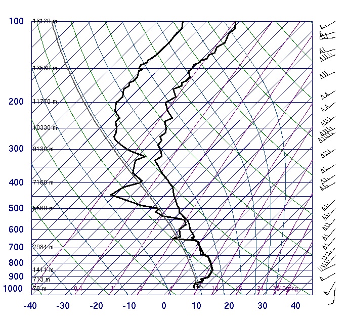
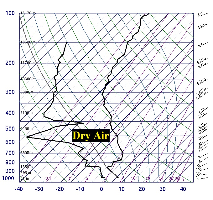
Another key ingredient of a winter storm is adequate moisture. While plotting surface dewpoints is a useful way to determine the amount of moisture currently available at ground-level, a better representation of the entire depth of the atmosphere can be gleaned through upper air soundings. Several of the computer models provide forecast soundings, giving meteorologists a glimpse of the expected conditions both at the surface and aloft several days in advance. Since the atmosphere is often quite cold and dry in winter, approaching storm systems sometimes don't have enough moisture to work with in order to produce significant precipitation. Other times, dry air at low-levels causes precipitation to initially evaporate before reaching the ground, thus making prediction of precipitation onset and overall accumulation tricky. Meteorologists therefore must have a good handle on the moisture content of the atmosphere in order to accurately predict precipitation type, intensity, duration, and accumulation. Below are two upper air soundings. The sounding on the left shows a moist mid and low-level airmass (temperature and dewpoint lines close to one another), while the sounding on the right has a substantial dry layer at mid and low-levels (temperature and dewpoint lines far apart). The moist sounding is obviously much more conducive to precipitation, while the drier profile suggests the potential for evaporation as precipitation initially arrives.
3) Temperature
As previously discussed in the Week #1 tutorial on Winter Precipitation Types, temperature plays a vital role in determining the type of precipitation that reaches the ground. A change of just 2-3 degrees can mean the difference between this...
A cold rain (33F)
and this...

Freezing rain (30F)
Meteorologists use computer models to determine the temperature throughout the depth of the atmosphere days in advance of an approaching winter storm system. Obviously forecasts are dependant upon individual model biases and can vary greatly from run to run. This makes predicting the exact temperature to within 1-2 degrees several days in advance extremely difficult.
NWS Winter Weather Products
Once all the variables have been examined and forecasters have determined what type of precipitation will fall and how much will accumulate, the threat is then communicated to the public through a variety of winter weather products. For winter events that are deemed to be a nuisance with minimal threat to life and property, an advisory will be issued.
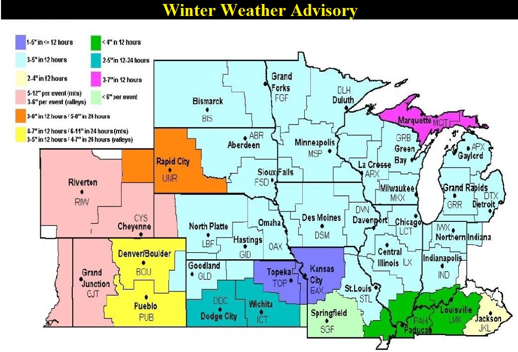
Winter Weather Advisory: Snow accumulation of 3-5 inches
Freezing Rain Advisory: Freezing rain accumulation of less than 1/4 inch
For winter events that are expected to be more serious and could potentially cause a significant threat to life and property, a warning will be issued.
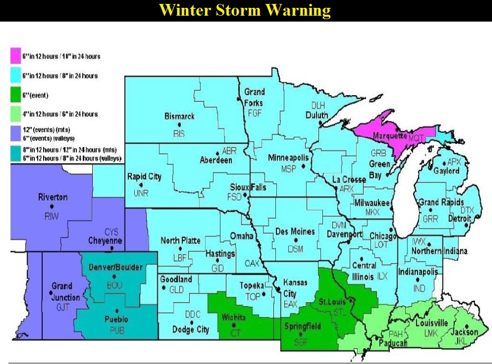
Winter Storm Warning: Snow accumulation of 6 inches or more in 12 hours...or 8 inches or more in 24 hours
Ice Storm Warning: Freezing rain accumulation of 1/4 inch or more
Blizzard Warning: Sustained winds of 35 mph or greater and 1/4 mile visibility due to falling or blowing snow for 3 or more hours
For your reference, here are the advisory and warning criteria at other NWS offices around the Midwest:
The Role of Weather Observers
After overcoming the numerous challenges associated with predicting winter storms across central Illinois, meteorologists then rely on weather observers to provide ground truth and verification of their forecasts. Real-time reports from the SWOP network supplement existing satellite and radar data and can significantly enhance the forecast. As a general rule, NWS Lincoln suggests the following from our SWOP members during winter storm events:
1) notification when precipitation begins at your location
2) notification when precipitation type changes (eg. snow to rain)
3) supplemental snowfall measurements during the storm (every 3 to 6 hours, but not more frequently)
4) final snowfall total once the snow ends
As always, if you have any questions about winter weather or how to obtain proper measurements, please feel free to e-mail us at: nwsliilx@noaa.gov Thank you for your hard work and continued support of the SWOP program. We appreciate it!
Week 1: Winter Precipitation Types

