Week 1: Winter Precipitation Types
Wintertime can bring a wide variety of precipitation types to central Illinois. Depending on the temperature, a storm system moving through the region could potentially produce heavy snow in the Illinois River Valley...a mix of freezing rain and sleet along the I-55 corridor...and strong to severe thunderstorms along and southeast of I-70! With this amount of variability over such a small area, forecasting precipitation type and amount for any specific location can be extremely challenging. The type of precipitation that reaches the ground during a winter storm depends on a number of variables...including the temperature within the cloud layer, the relative humidity below the cloud layer, the depth and temperature of any potential warm layer aloft, and of course the surface temperature. These variables can be sampled by a number of methods, but perhaps the most important is the release of an upper air balloon from NWS Lincoln at 6am and 6pm each day. Instruments attached to the balloon provide forecasters with a trace of the temperature, dewpoint, and wind speed/direction throughout the depth of the atmosphere. This information helps us better assess the total environment and provide a more accurate depiction of expected precipitation type. In order to more clearly understand the complexities involved with precipitation type forecasting, please refer to the diagram below.
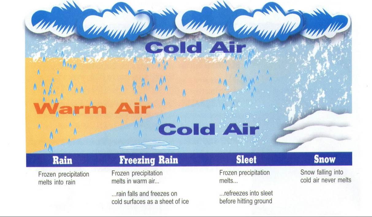
Temperatures are typically well below freezing within the cloud layer during the wintertime: however, this does not necessarily ensure that the cloud contains ice crystals. It has been shown through scientific studies that the optimum temperature for ice crystal development and growth is -12C (10F) or colder. Once the minimum temperature of the cloud layer is determined through either direct measurement via an upper air balloon launch or through forecast model soundings, the initial phase of the precipitation particle within the cloud can be surmised. At temperatures between 0C and -12C, the cloud likely contains supercooled liquid water droplets. Once temperatures cool to less than -12C, the chances of the cloud containing ice crystals increase significantly. In most wintertime scenarios, temperatures aloft are cold enough to support ice crystals, so the precipitation particle begins its life cycle as a snowflake. Now let's determine what happens to that snowflake as it descends through the atmosphere:
1) Rain
In most cases, temperatures warm with decreasing altitude. If the snowflake falls through a significant depth of above freezing air on its way to the ground, it will melt into a rain drop as seen on the far left side of the diagram above.
2) Freezing Rain
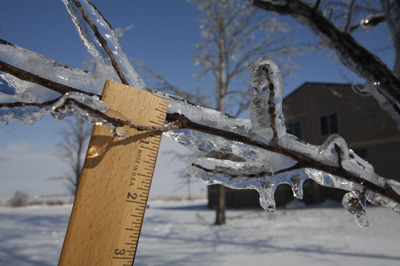
Sometimes a shallow layer of sub-freezing air exists near the surface. This may occur ahead of an approaching warm front when the warmer air typically arrives aloft before it arrives at ground level, especially if there is an existing snow cover to keep surface temperatures near or slightly below freezing. In this case, the rain drop will freeze upon contact with the ground creating a glaze of ice. Measuring ice accumulation can be a bit tricky, but the best bet is to find a tree or shrub branch that has been coated with ice and use a ruler or a tape measure. Since water has a tendency to drip off the branch, the thickness of the ice will usually be greater on the underside of the branch than on the top side. To get an accurate reading, measure the thickness on both sides and divide by two to get an average ice accumulation. For example: 3/4" ice on bottom of branch, 1/4" ice on top...(3/4 + 1/4) divided by 2 yields an ice accumulation of 1/2."
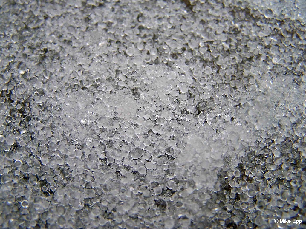
3) Sleet
If the raindrop encounters a thicker layer of sub-freezing air near the surface, it will have enough time to freeze into a tiny ball of ice known as sleet. Sleet typically bounces when it hits the ground and can eventually form a crusty glaze if enough of it accumulates. Large amounts of sleet are rare, as it usually transitions to freezing rain or rain within a relatively short period of time. Sleet is measured the same way snow is and can be included as part of your snowfall total.
4) Snow
If the entire depth of the atmosphere is near or below freezing, then a snowflake originating in the cloud layer will fall to the ground as seen on the far right side of the diagram above.
Many times an approaching storm system can bring a mixed bag of wintry precipitation. For example, the precipitation may start as snow...but when warmer air begins to move in aloft, it could transition to sleet, freezing rain, and eventually rain. This presents a challenge to weather observers who want to provide accurate measurements of snow and sleet. To mitigate the issue of changing precipitation types, NWS Lincoln suggests taking a measurement every 3 to 6 hours during the event if possible. If this is not feasible and you are away from your station (i.e at work) while the transition occurs, please take a measurement as soon as you can when you return to your station and indicate that you were not home when the precipitation fell. In some cases, obtaining an accurate measurement will be impossible, especially if snow was initially falling but changed to rain and melted any accumulation that you received before you get home. In this instance, consider having a family member or friend take a back-up measurement in your absence. Given the complexity of winter storms across central Illinois, the National Weather Service appreciates any and all reports. If you have any questions about how to obtain readings, please feel free to contact us at: nwsliilx@noaa.gov.
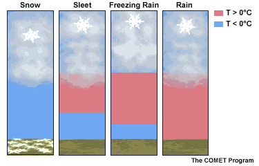
A graphical depiction of the various winter precipitation types.

