Top 10 Weather Events of 2024
1) January 8-13: Heavy Snow Across the Illinois River Valley
Two powerful winter storm systems impacted the Midwest during the week of January 8th through January 13th...bringing high winds, heavy rain, thunderstorms, heavy snow, and blizzard conditions to parts of the region.
System #1: Low pressure tracking from the Oklahoma panhandle during the morning of January 8th to southeast Michigan by the evening of January 9th spread a mixture or rain and snow across central Illinois. Light snow developed everywhere north of the I-70 corridor by the evening of January 8th: however, as the low approached from the southwest and temperatures warmed, the snow changed to rain east of the Illinois River by the morning of January 9th. Snow accumulations of 2 to 3 inches occurred along and west of a Jacksonville to Bloomington line...while amounts of 5 to 7 inches were observed west of the Illinois River where the precipitation remained mostly in the form of snow throughout the entire event.
System #2: A 996mb low over western Oklahoma during the evening of January 11th deepened to 981mb as it tracked northeastward into Michigan by the evening of January 12th. Light rain developed across much of central Illinois initially...with heavy wet snow occurring along and north of a Keokuk, Iowa...to Peoria...to Pontiac line. With elevated instability increasing, scattered convection developed as well....with thundersnow being observed at Altona in Knox County. As the low tracked between the I-55 and I-57 corridors during the day of January 12th, enough warm air was drawn northward to change the wet snow over to a period of rain. Snowfall of 6 to 10 inches was observed across portions of Knox, Stark, and Marshall Counties.
Once the second storm departed, ferocious winds over fresh snow cover created blizzard conditions across Iowa into northwest Illinois where blowing snow cut visibilities to one quarter of a mile or less at times. Storm total snowfall from the two systems combined exceeded 8 inches along and northwest of a Quincy...to Peoria...to Watseka line. Even higher totals of 18 to 24 inches were observed further northwest near the Mississippi River along and northwest of a Burlington, Iowa to Kewanee line. Within the NWS Lincoln County Warning Area (CWA), the highest total of 20.3 inches was measured by an observer in Altona in far northern Knox County. Meanwhile Peoria picked up 10.7 inches while parts of northern Fulton County into Woodford County got as much as 7 to 9 inches. Amounts decreased sharply further southeast...with 1 inch or less everywhere along and south of the I-72 corridor.
=============================================================================================================================
2) January 13-16: Bitterly Cold Conditions
As a deepening area of low pressure lifted northeastward into the Great Lakes, strong northwesterly winds gusting over 40mph brought sharply colder air into central Illinois during the night of January 12th. Temperatures plunged into the single digits above zero by the morning of January 13th, then didn't climb back into the teens until the afternoon of January 17th. The coldest day during this period was January 14th when high temperatures remained below zero and overnight lows plummeted into the teens below zero everywhere north of the I-70 corridor. Record cold high temperatures were established at many sites: including -5 at Peoria, -3 at Springfield, and -3 at Lincoln. Winds were strongest immediately behind the departing system into January 13th, but remained a factor until air temperatures gradually warmed. The resulting wind-chill values dropped as low as -25 to -35 at times, creating extremely dangerous conditions for anyone venturing outdoors. Below is a table depicting high temperatures from January 13th through 17th. Values in blue indicate record cold high temperatures.
| DATE | Peoria | Lincoln | Springfield |
| Jan 13 | 20 | 18 | 18 |
| Jan 14 | -5 | -3 | -3 |
| Jan 15 | 2 | 4 | 7 |
| Jan 16 | 8 | 9 | 9 |
| Jan 17 | 25 | 27 | 29 |
=======================================================================================================================
3) Record Warmth in Late February
Upper-level ridging brought record-breaking warmth to parts of the Midwest in late February. As a warm front passed through central Illinois, temperatures climbed from near seasonal averages in the lower to middle 40s on February 24th into the middle 60s by February 25th. With the jet stream well to the north and southerly flow locked in place, temperatures continued to rise for the next couple of days...culminating in readings in the upper 70s to around 80 degrees on February 27th. Daily and all-time monthly high temperature records were established at Peoria, Lincoln, and Springfield on the 27th. The unusual late winter heatwave was short-lived however, as a cold front brought temperatures back down into the 30s by February 28th. The table below shows daily high temperatures from February 25th through 27th. Numbers in red indicate record high values.
| DATE | Peoria | Lincoln | Springfield |
| Feb 25 | 66 | 65 | 67 |
| Feb 26 | 77 | 76 | 76 |
| Feb 27 | 78 | 78 | 80 |
=============================================================================================================================
4) March 31: Prolific Hail-Producing Supercell
A supercell thunderstorm developed along a warm front just south of Macomb during the early evening of March 31st. The storm tracked southeastward, continuously dropping 1 to 2-inch diameter hail from southern Fulton County to western Douglas County before gradually weakening well after dark. The largest hail stones measuring 2.5 inches in diameter fell on the northeast side of Decatur in Macon County.
MARCH 31 7:25PM CDT RADAR IMAGERY
LARGE HAIL ON THE WEST SIDE OF DECATUR
=============================================================================================================================
5) May 21: Dust Storm
Deep-layer mixing within a dry pre-frontal airmass resulted in strong southerly winds gusting 40-50mph across central Illinois on May 21st. Scattered showers and thunderstorms well ahead of the front brought higher momentum air down to the surface causing localized gusts of 55-65 mph during the evening. Due to recently plowed farm fields and dry conditions, the strong winds were able to loft dust from the fields, creating widespread reductions in visibility...with a few spots reporting near zero visibility at times. Several major highways were temporarily closed due to the dust...including I-55 near Shirley and McLean in McLean County, I-155 near Hopedale in Tazewell County, and I-74 between LeRoy and Farmer City in McLean and DeWitt counties. A number of traffic accidents occurred due to the poor visibility, including one that injured 6 people on IL-54 between Mount Pulaski and Chestnut in southern Logan County.
=======================================================================================================================
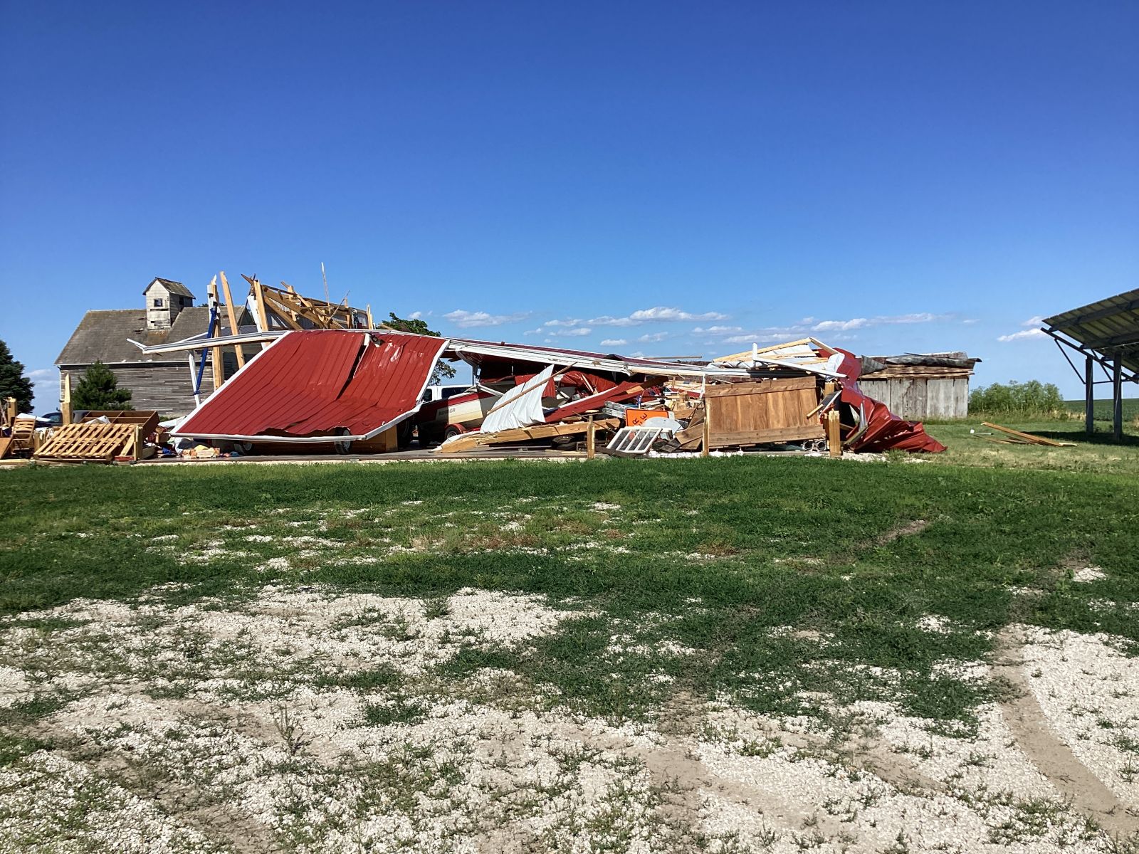
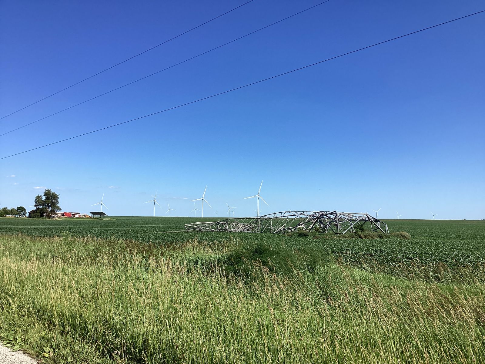
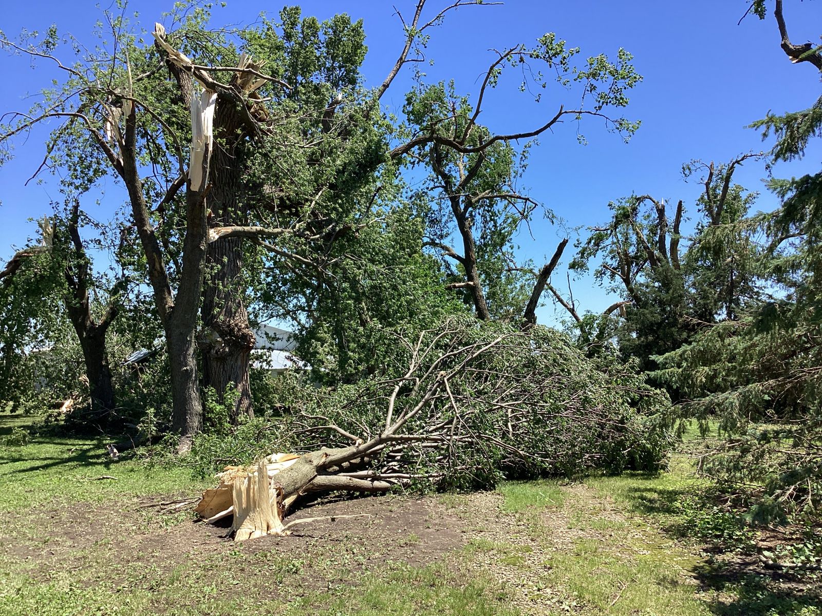
6) June 13: 5 Tornadoes and High Winds Across Eastern McLean County
A cold front triggered clusters of strong to severe thunderstorms across north-central Illinois during the evening of June 13th into the pre-dawn hours of June 14th. Most of the activity occurred along and north of a Beardstown to Champaign line. Numerous trees and power lines were blown down thanks to 60-70 mph wind gusts, while a few reports of hail as large as quarters were also received. The most significant wind damage was focused across northeastern McLean County from Chenoa and Lexington southeastward through Cropsey and Anchor where a damage survey team determined widespread wind gusts of 80-110 mph as well as 5 tornado touchdowns had occurred. A total of 33 high-tension electrical transmission towers were severely damaged as a result of the powerful winds across this area.
SOUTHEAST OF CHENOA SOUTHEAST OF CHENOA
 |
 |
EAST OF ANCHOR NEAR THE FORD COUNTY LINE
 |
 |
=======================================================================================================================
7) July 15: Derecho
A powerful line of thunderstorms known as a derecho swept across eastern Iowa and the northern halves of Illinois and Indiana during the evening of July 15th into the pre-dawn hours of July 16th. The National Weather Service defines a derecho as a swath of thunderstorm wind damage greater than 240 miles in length with wind gusts in excess of 58mph along the entire path.
The July 15th derecho left behind a wide swath of wind damage primarily along and north of a Des Moines, Iowa...to Lincoln, Illinois...to Indianapolis, Indiana line. The most significant and widespread damage in central Illinois occurred across Stark County and northern Peoria County eastward into Marshall and northern Woodford counties where numerous trees and power lines were blown down. This was the location within one of the bowing segments of the derecho where wind gusts of over 80mph were common. In fact, there were two reports of home weather stations logging winds in excess of 100mph near Speer in Stark County and in Dunlap in Peoria County. Further southeast, many reports of trees being blown down were received...including some that blew onto vehicles and homes. Significant power outages occurred as well, with many residents of north-central Illinois still without power as of the morning of July 17th. In addition, 10 tornado touchdowns occurred along the leading edge of the storms within the NWS Lincoln County Warning Area (CWA)...ranging in strength from EF-U to EF-1. Below is a radar image as the storms were approaching the Illinois River. Rear-inflow jets are denoted by white arrows, showing where the most powerful winds were causing the line of convection to bulge forward.
JULY 15 8:12PM CDT RADAR IMAGERY
JULY 15 STORM REPORTS (W: Wind, H: Hail, T; Tornado)
=============================================================================================================================
8) September 27: High Winds from the Remnants of Hurricane Helene
Hurricane Helene slammed into the Florida panhandle during the evening of September 26th as a powerful Category 4 storm with a minimum central pressure of 938mb and maximum sustained winds of 140mph. The storm tracked northeastward across Georgia, then curved northwestward and slowed as it crossed the southern Appalachians. Due to copious Gulf of America moisture flowing upslope into the mountains, catastrophic flooding occurred across portions of western North Carolina and South Carolina as well as far eastern Tennessee. The remnants of Helene lifted slowly northwestward across Kentucky during the afternoon of September 27th...with a 988mb low analyzed west of Louisville, Kentucky by early evening (see map below). As the pressure gradient tightened, very strong northerly winds developed across central Illinois. The strongest wind gusts of 55-65mph were concentrated along and southeast of a Champaign to Decatur line, where scattered minor wind damage occurred. A peak wind gust of 66mph was measured at the Coles County Memorial Airport between Mattoon and Charleston.
SEPTEMBER 27 7PM CDT SURFACE MAP
=============================================================================================================================
9) Late October Drought and Field Fires
Drought conditions developed across central Illinois during the fall...culminating in an extremely dry October that saw monthly rainfall deficits of 2 to 3 inches and deficits since September 1st of 3 to 5 inches.
| Peoria | Lincoln | Springfield | |
| October Rainfall | 0.98 | 0.73 | 1.42 |
| Deficit | -2.19 | -2.69 | -1.84 |
| September-October Rainfall | 1.70 | 1.71 | 3.08 |
| Deficit | -4.95 | -5.01 | -3.06 |
Below is a comparison of the U.S. Drought Monitor on October 1st and October 29th. Note the expansion of Moderate Drought (D1) across all of central Illinois and the development of Severe Drought (D2) from the I-74 corridor northeastward into the Chicago area during the month of October.
OCTOBER 1 OCTOBER 29
Thanks to very low fuel moisture, relative humidity values less than 30 percent, and strong southerly winds gusting over 40mph, several field fires developed on October 29th. One of the largest formed about 1 mile south-southeast of Ogden in Champaign County, then rapidly spread northeastward across I-74 just east of Ogden. Based on Sentinel-2 satellite data from November 10th, the fire scar was approximately 2.5 miles in length with a maximum width of about 1 mile While no structures were directly impacted, I-74 was closed for a little over 2 hours between the St. Joseph exit (mile marker 192) and Fithian exit (mile marker 200). Here are some high-resolution satellite images of burn scars observed across the area:
OGDEN
EDGAR
WESTVILLE
=============================================================================================================================
10) 31 Tornadoes Across Central Illinois in 2024
A typical year sees 20-25 tornado touchdowns within the NWS Lincoln County Warning Area (CWA). This year most of our tornadoes (23) occurred in the summer months...with 11 touching down on one day (July 15). The strongest tornado to impact the Lincoln CWA was an EF-2 that tracked out of Marion County into western Clay County on May 26.
Winter (1)
| DATE | COUNTY | BEGIN LOCATION | EF-SCALE |
| February 8 | Marshall | 3 miles south of Henry | EF-1 |
Spring (7)
| DATE | COUNTY | BEGIN LOCATION | EF-SCALE |
| March 14 | Fulton | 2 miles northwest of Avon | EF-1 |
| April 18 | Logan | 3 miles west-southwest of Latham | EF-1 |
| April 18 | Logan | 1.5 miles south-southeast of Latham | EF-1 |
| April 18 | Macon | 1 mile west of Warrensburg | EF-1 |
| April 18 | Macon | 2 miles north of Forsyth | EF-1 |
| May 26 | Clay | 5.3 miles northwest of Xenia | EF-2 |
| May 26 | Lawrence | 3 miles south of Sumner | EF-1 |
Summer (23)
| DATE | COUNTY | BEGIN LOCATION | EF-SCALE |
| June 5 | Vermilion | 3.5 miles south of East Lynn | EF-1 |
| June 13 | McLean | 3 miles east-northeast of Lexington | EF-1 |
| June 13 | McLean | 5 miles southeast of Chenoa | EF-1 |
| June 13 | McLean | 5 miles northeast of Pleasant Hill | EF-1 |
| June 13 | McLean | 2 miles east-southeast of Anchor | EF-1 |
| June 13 | McLean | 2 miles south-southeast of Anchor | EF-1 |
| June 29 | Vermilion | 1.5 miles south-southeast of Cheneyville | EF-0 |
| July 14 | Marshall | 1 mile north of Henry | EF-1 |
| July 14 | Marshall | 2 miles south-southeast of Henry | EF-1 |
| July 14 | Marshall | 2.5 miles east-northeast of Varna | EF-U |
| July 14 | Marshall | 3 miles east-northeast of Varna | EF-U |
| July 15 | Marshall | 2 miles southeast of Lacon | EF-1 |
| July 15 | Knox | 2 miles north of Williamsfield | EF-1 |
| July 15 | Peoria | Monica | EF-0 |
| July 15 | Peoria | 4 miles west of Dunlap | EF-1 |
| July 15 | Peoria | 3 miles northwest of Alta | EF-0 |
| July 15 | Woodford | 1 mile southwest of Germantown Hills | EF-1 |
| July 15 | Woodford | 2 miles west-southwest of Cazenovia | EF-0 |
| July 15 | Woodford | 1 mile southeast of Germantown Hills | EF-1 |
| July 15 | Tazewell | East Peoria | EF-1 |
| July 15 | Tazewell | South of Deer Creek | EF-U |
| July 15 | Woodford | 2 miles east-southeast of Minonk | EF-0 |
| August 15 | Stark | 3 miles northwest of West Jersey | EF-1 |
Fall (0)