Top 10 Weather Events of 2019
1) January 11-13 Heavy Snow
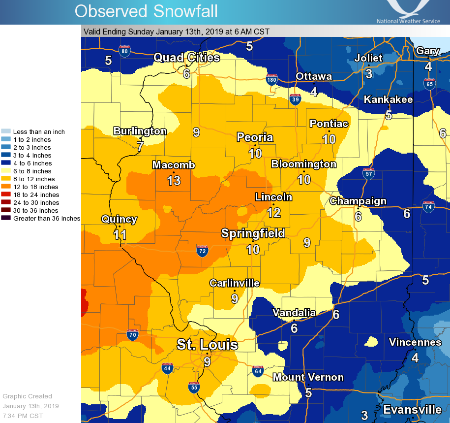
A slow-moving storm system brought a prolonged period of snow to central Illinois from the evening of January 11th through the morning of January 13th. Snow began across the Illinois River Valley during the evening of January 11th as low pressure developed over the Texas panhandle. As the low tracked slowly northeastward into Kentucky, light to moderate snow continued through January 12th before gradually tapering off and coming to an end by midday of the 13th. Widespread snowfall in excess of 6 inches occurred along and north of the I-70 corridor...with as much as 12 to 16 inches falling along and southwest of a Macomb to Lincoln line. The highest observed snowfall total was 16.0 inches just west of Jacksonville in Morgan County. Numerous traffic accidents occurred due to snow-covered roads.
=============================================================================================================================
2) Record Cold in Late January
An unseasonably deep upper-level low dug into the Great Lakes at the end of January...setting up a period of record-breaking cold from January 29th through January 31st. As the low established itself, it pushed an Arctic cold front through central Illinois during the afternoon of January 29th. Temperatures dropped below zero by the evening of the 29th...then remained there until around midday on January 31st. Peoria officially logged 42 consecutive hours below zero, while Springfield came in with 33 hours. The coldest temperatures were observed during the morning of January 30th when record lows were established at Peoria (-20), Lincoln (-19), and Springfield (-14). In addition to the extreme cold, brisk northwesterly winds created dangerous wind chills of -40 to -50...with Central Illinois Regional Airport in Bloomington reporting their all-time coldest wind chill of -53!
| January 29 | January 30 | January 31 | |
| Peoria | high: 10 low: -6 | high: -6 low: -20 | high: 9 low: -19 |
| Lincoln | high: 13 low: -3 | high: -3 low: -19 | high: 14 low: -12 |
| Springfield | high: 16 low: 1 | high: 1 low: -14 | high: 19 low: -14 |
========================================================================================================
3) May 16th Very Large Hail in Vermilion County
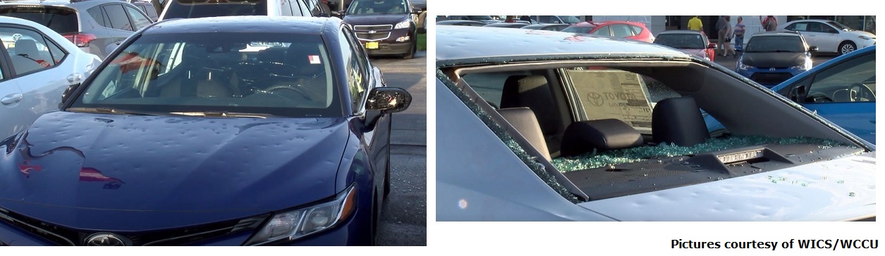
A complex of thunderstorms that developed over northern Illinois dropped southeastward into north-central Indiana during the afternoon of May 16th. Due to a very unstable airmass feeding into the complex, several supercell thunderstorms developed along its southwestern flank. These cells skirted across Vermilion County, producing hail as large as baseballs and damaging wind gusts in excess of 60 mph. The large hail caused nearly 4 million dollars damage to a Toyota dealership in Tilton.
========================================================================================================
4) May 22-29 Active Severe Weather
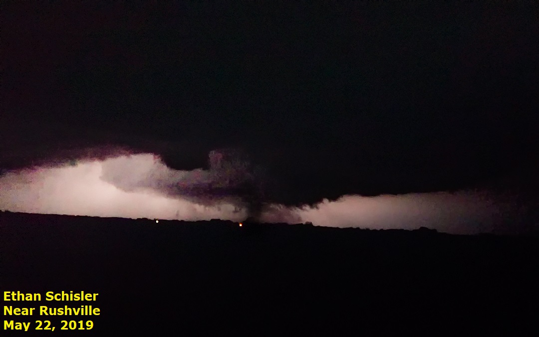
An active period of weather brought numerous rounds of thunderstorms to central and southeast Illinois from May 22nd through May 29th. Severe weather occurred within National Weather Service Lincoln's County Warning Area (CWA) on each day during that time frame...including damaging wind gusts in excess of 70mph, hail as large as tennis balls, and a total of 19 tornadoes. In addition, heavy rainfall continued to delay planting and aggravate ongoing flooding along the Mississippi and Illinois Rivers as portions of west-central Illinois picked up in excess of 5 inches of rain. Here is a picture of the first tornado from this prolonged event. It briefly touched down east of Rushville in Schuyler County during the evening of May 22nd.
Some of the most significant severe weather of the period took place on May 23rd when a total of 5 tornadoes touched down...including 4 EF-1 tornadoes with estimated winds in excess of 100mph. These storms occurred well after dark along the leading edge of a squall line and primarily impacted portions of Sangamon, Piatt, and Logan counties. The most significant damage was reported near Cantrall in Sangamon County where a farm was damaged and an outbuilding was destroyed. This particular tornado went on to destroy a large machine shed on the Menard/Logan County line before dissipating about 1 mile west of Broadwell in Logan County.
Another notable round of stormy weather was observed during the afternoon of May 28th as a few supercell thunderstorms developed within a very unstable airmass. One cell that formed in DeWitt County then tracked eastward across northern Champaign County produced very large hail early in its life cycle. The largest stones were the size of tennis balls near DeLand in northern Piatt County. Below is a pic of the very large hail in DeWitt County from the afternoon of the 28th.

========================================================================================================
5) June 30 Damaging Wind Event
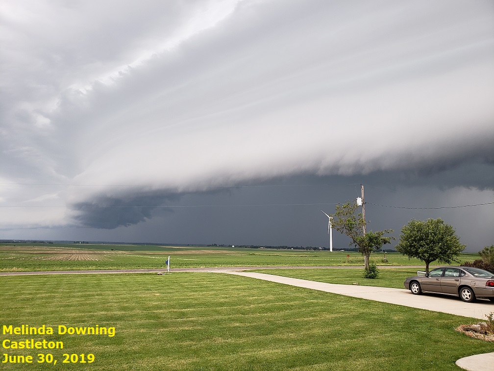
An upper-level disturbance interacting with a nearly stationary frontal boundary draped across northern Illinois triggered several clusters of strong to severe thunderstorms during the afternoon of June 30th. The storms initiated in Wisconsin, then tracked southeastward into east-central Illinois mainly east of the I-55 corridor. Wind gusts as high as 60-70 mph downed numerous trees and power lines, while hail as large as half dollars was reported in a few spots. Meanwhile further west, 40-50 mph winds along a thunderstorm outflow boundary blew a 6-inch diameter tree branch onto a man in Peoria. The man later died from his injuries. Here is a picture taken near Castleton in northern Stark County of a shelf cloud along the leading edge of the thunderstorms.
========================================================================================================
6) July 17-21 Heatwave
A large ridge of high pressure building over the Midwest brought a period of hot and humid weather to central Illinois from July 17th through July 21st. High temperatures routinely topped out in the lower to middle 90s during that time frame, while overnight lows only cooled into the middle to upper 70s. High relative humidity values helped push maximum afternoon heat index values to 105 degrees or higher. A cold front eventually brought relief to areas along and west of I-55 by July 21st...with cooler conditions not arriving further east until the 22nd. Due to the prolonged period of excessive heat and humidity, two people died of heat-related illnesses across central Illinois. An 81-year old man in Flora in Clay County passed away on July 18th, while a 61-year old woman died in Peoria on July 21st.
========================================================================================================
7) August 20 Damaging Wind Event
Remnants of a large cluster of nocturnal thunderstorms over Iowa pushed into west-central Illinois during the early morning of August 20th. The leading edge of the storms intensified as it approached the I-55 corridor, then continued eastward to the Indiana border by around midday. Widespread wind damage accompanied the storms...primarily along and north of a Jacksonville...to Decatur...to Danville line. Peak wind gusts observed at area airports included: 58mph at Springfield, 55mph at Decatur, and 45mph at Peoria. Below is a picture of a shelf cloud over Clinton Lake taken by one of our long-time SWOP members.

========================================================================================================
8) September 27-October 2 Active Weather
An unusual weather pattern more characteristic of mid-summer than early fall developed across the Midwest from September 27th through October 2nd. A strong upper-level ridge of high pressure expanded across the Deep South, building as far north as central Illinois. An impressive dome of record-setting heat developed beneath the high as afternoon high temperatures soared into the upper 90s to near 100 degrees from parts of Kentucky southward to the Gulf Coast. Meanwhile further north into Illinois, readings climbed into the upper 80s and lower 90s. Springfield tied their previous record high of 91 degrees on both September 27th and October 1st...while Lincoln tied their old record of 91 on October 1st. In addition to the heat, unseasonably high dewpoints in the upper 60s and lower 70s created heat index readings well into the 90s.
With the upper high over the Deep South holding firm, most of the convection that developed from Friday, September 27th through Monday, September 30th was focused north of a Rushville to Bloomington line. As the high slowly weakened, a cold front eventually pushed through Illinois and brought showers and thunderstorms further southeastward across the remainder of the region. Here is a map of the total rainfall from September 27th through October 2nd. All locations along and north of a Taylorville to Danville line saw greater than 1 inch...with a maximum of 6 to 10 inches noted from eastern Peoria County across northern Woodford and southern Marshall counties. Peoria set a new daily rainfall record for September 27th when a whopping 3.14 was observed. Springfield established a new daily rainfall record just a couple of days later on September 29th when 3.30 occurred.
There were also a couple rounds of severe weather during this unseasonably hot and wet period. On Friday, September 27th several reports of damaging wind gusts and large hail were received along a Quincy...to Peoria...to Kankakee line. Then on Sunday, September 29th, scattered severe thunderstorms brought large hail and damaging wind gusts from just east of Macomb eastward to near Champaign. Hail as large as tennis balls was reported just north of Lewistown in Fulton County and an EF-0 tornado touched down near Emden in northern Logan County.​
========================================================================================================
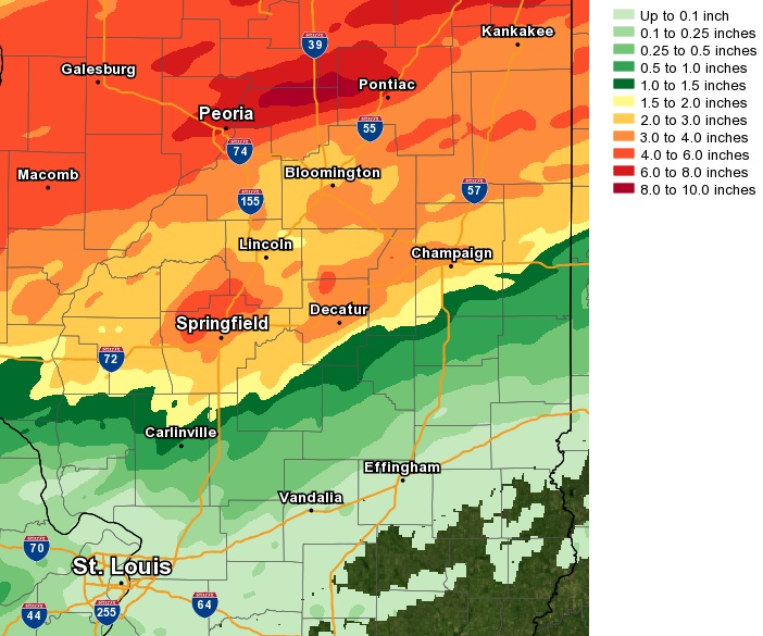
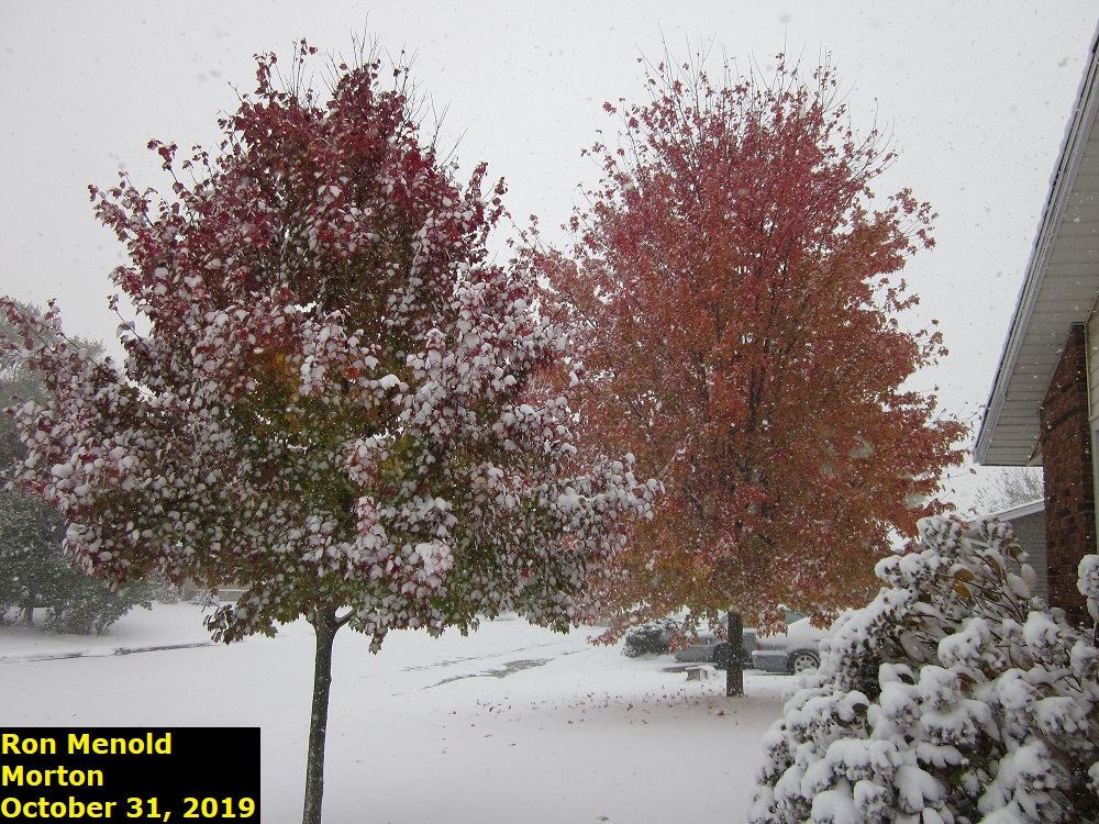
9) Halloween Snowfall
An unseasonably cold airmass settled into central Illinois at the end of October with high temperatures only reaching the 30s on October 30th and 31st. In fact, many locations set records for the coldest high temperature ever observed on October 31st...including Peoria at 32 degrees and both Springfield and Lincoln at 34 degrees. In addition to the cold conditions, low pressure tracking northward along a slowly-departing cold front brought a period of wet snow to much of the area. Snow began falling in the Illinois River Valley during the pre-dawn hours of Halloweeen, while light rain occurred further east where it was slightly warmer. As colder air filtered into the region, the rain gradually transitioned to snow as far east as the Indiana border by around midday before the precipitation came to an end. Total snowfall from this early season system, exceeded 1 inch along and north of a Jacksonville...to Decatur...to Danville line...with as much as 3 to 5 inches occurring along and north of a Macomb to Pontiac line. The highest total observed within the National Weather Service Lincoln County Warning Area (CWA) was 5 inches at both Williamsfield in Knox County and 3 miles south of Hanna City in Peoria County.
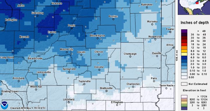
Peoria observed its heaviest October snowfall on record with a total of 3.9 inches. With snow also occurring the previous two days, the monthly total of 4.2 inches also broke the monthly snowfall record of 3.3 inches, which was set in 1929.
Springfield received 2.3 inches of snow on Halloween. This was only the 7th measurable October snow on record and was enough to be the 3rd snowiest October day on record. The monthly total also was the 3rd highest on record for October.
========================================================================================================
10) Record Warm Christmas
A pronounced upper-level ridge of high pressure developed from the Southern Plains into the Ohio River Valley on December 22nd. As upper heights rose and light southerly flow persisted, temperatures began warming in the days leading up to Christmas. With increasingly warm and moist air flowing northward over the cold ground, widespread fog developed during the early mornings of both December 23rd and 24th. Despite the foggy start and the presence of a high/thin overcast at times, temperatures warmed into the upper 50s on December 24th...then reached the lower to middle 60s on the 25th and 26th. Record highs were established in many central Illinois communities on Christmas Day and the day after before a strong cold front brought an end to the unusual stretch of warm late December weather.
| December 24 | December 25 | December 26 | |
| Peoria | 59 | 63 (62 in 1936) | 63 (59 in 1942) |
| Lincoln | 58 | 64 (62 in 1982) | 65 (62 in 1942) |
| Springfield | 59 | 64 (62 in 1982) | 64 (67 in 1942) |

