Top 10 Weather Events of 2018
1) Extremely Cold Start to the Year
A persistent upper-level trough of low pressure dominated the Great Lakes/Midwest from late December 2017 through the first week of January 2018...during which time numerous bouts of Arctic air invaded central Illinois. The coldest day was January 1, 2018 when many locations along and north of the I-72 corridor remained below zero for the entire day...with average daily temperatures of 30 to 35 degrees below normal. Temperatures remained bitterly cold for several days afterwards, with readings finally climbing above 32F by January 7th after a remarkable stretch of 14 consecutive sub-freezing days. Below is a chart of the highs and lows for various central Illinois cities on January 1, 2018:
| City | High | Low | Daily Average | Daily Departure from Normal |
| Peoria | -2 | -16 | -9 | -34 |
| Springfield | 4 | -13 | -4 | -31 |
| Lincoln | -2 | -15 | -8 | -34 |
| Champaign | -4 | -15 | -9 | -35 |
| Mattoon | 2 | -11 | -4 | -32 |
| Lawernceville | 12 | -2 | 5 | -26 |
===============================================================================================================================
2) Cold/Snowy April
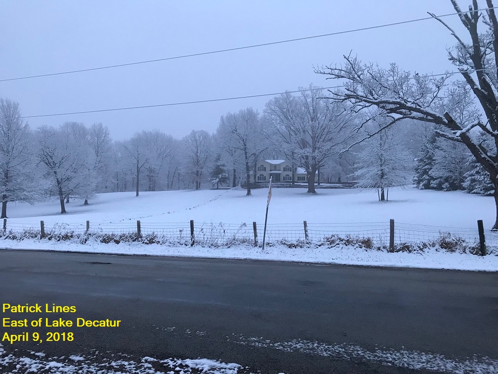
After a relatively chilly March featuring monthly average temperatures ranging from 1.5 to 3 degrees below normal, the weather remained unseasonably cool through the first half of April. Several intrusions of cool, Canadian air prevented readings from consistently warming as is typically noted during this time of year. High temperatures struggled to climb through the 30s and 40s on numerous days early in the month, resulting in monthly temperature departures of 5 to 8 degrees below normal. Springfield recorded an average monthly temperature of 5.6 degrees below normal, while Peoria was 7.2 degrees below normal, and Lincoln came in at 8.1 degrees below normal. In addition to the cool conditions, several early Spring storm systems brought snow to central Illinois during the month of April...the most significant of which dropped 6 to 8 inches of snow from Mason and Menard counties westward to the Mississippi River on April 1st. Another disturbance brought accumulating snow of 2 to 4 inches just one week later on April 8th...with measureable snowfall of at least a trace occurring as late as April 19th at most observing sites. Here is a photo of the April 8-9 snowfall submitted by one of our SWOP team members:
===============================================================================================================================
3) April 3rd Flash Flooding in Mattoon-Charleston
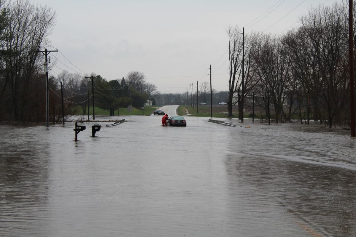
Low pressure tracked from the Ozarks northeastward into northern Indiana on April 3rd...bringing widespread rain and thunderstorms to much of central and southeast Illinois. Moderate to heavy rain moved into the southern parts of Coles County shortly after 7am CDT. Thunderstorms caused the rain to intensify between 9 and 10am CDT, when nearly 2 inches of rain was measured. Total rainfall ranged from 4 to 6 inches in about a nine hour period. Flash flooding rapidly developed in Mattoon-Charleston...where numerous streets were flooded. Illinois Route 16 was closed in several spots, as well as parts of I-57 between mile markers 184 and 192. Five houses in Mattoon were flooded with 3 to 5 feet of water due to Kickapoo Creek spilling out of its banks, resulting in the evacuation of 11 people. Numerous water rescues were conducted by local officials for people trapped in vehicles. Lakeland College just south of Mattoon cancelled classes due to road closures from the flooding. Below is a photo of a water rescue southeast of Mattoon on April 3rd.
===============================================================================================================================
4) Very Hot May
After an unseasonably cool Spring that saw measurable snowfall well into the month of April, the weather took a sudden turn to summer-like heat in May. Thanks to an abrupt pattern change featuring strong upper-level ridging centered over the Midwest, average monthly temperatures ranged from 8 to 11 degrees above normal. In fact, many locations across central and southeast Illinois experienced their hottest temperature of the entire year on either May 27th or 28th when readings soared into the upper 90s. Below is a chart of the high temperatures on May 27-28, 2018 and the monthly departure from normal. The starred values are the highest temperature reading for that particular location for all of 2018.
| City | May 27th High | May 28th High | Monthly Departure from Normal |
| Peoria | 97* | 95 | +9.3 |
| Springfield | 97 | 98* | +10.8 |
| Lincoln | 92 | 94* | +8.3 |
| Champaign | 95 | 97* | +9.2 |
| Mattoon | 93 | 94* | +9.0 |
| Lawrenceville | 94 | 97 | +9.5 |
==========================================================================================================
5) June 10th Large Hail in Cass County
An area of low pressure tracking along a nearly stationary frontal boundary triggered a round of severe thunderstorms across central Illinois during the afternoon of June 10th. The main line of storms produced 60-80mph wind gusts and widespread wind damage from portions of Tazewell and McLean counties southeastward through Champaign and Edgar counties. Two brief EF-0 tornadoes spun up along the leading edge of the line, creating pockets of enhanced damage on the southwest side of the city of Champaign. An additional severe thunderstorm cell developed further west near the Illinois River later in the afternoon...producing a swath of hail up to the size of tennis balls from 1.6 miles southwest of Bluff Springs to the town of Bluff Springs in Cass County. Roofs of homes and automobiles were damaged. These were the largest hailstones reported within the NWS Lincoln County Warning Area (CWA) in 2018.
===============================================================================================================================
6) Tropical Storm Gordon
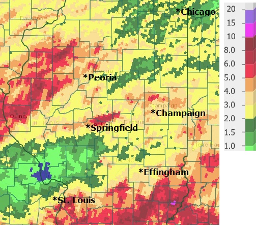
Heavy rain impacted central and southeast Illinois as the remnants of Tropical Storm Gordon tracked from Arkansas during the afternoon of September 7th to southern Ohio by the afternoon of September 9th. The rainfall was further enhanced by a weak cold front dropping southward out of the Upper Midwest. Rainfall was heaviest south of I-70 in closer proximity to the track of the storm, with amounts ranging from 5 to 10 inches. Another area of heavy rain materialized northwest of the Illinois River as the cold front approached, with totals of 4 to 6 inches. The highest rainfall amounts observed within the SWOP network were 8.00 at Robinson 3W, 7.36 at Ste. Marie 1NW, 6.93 at Latham 2SW, 6.62 at Mossville 1S, and 6.45 at Knoxville. Due to the prolonged period of heavy rainfall, flash flooding developed...mainly along and southeast of a Newton to Flora line where numerous roads were closed due to high water. Here is a map of the rainfall totals from Gordon:
===============================================================================================================================
7) High Winds in October
High winds impacted central Illinois on consecutive weekends in late October. The first event occurred during the afternoon of Saturday, October 20th when strong northwesterly winds developed in the wake of a departing cold front. The winds were enhanced as a powerful low-level jet streak mixed to the surface during peak heating, creating widespread gusts in excess of 45mph. A few locations reported even higher gusts, with the Coles County Memorial Airport coming in at 58mph and the University of Illinois Willard Airport logging a peak gust of 59mph. Due to the high winds, scattered wind damage occurred across the area...including a gas station awning being blown over at the intersection of I-57/I-70 and U.S. 45 near Effingham and a 20-inch diameter tree toppling across a road on the west side of Paris.
The second high wind event occurred just one week later when a deepening area of low pressure tracking from southern Minnesota into northern Indiana created high winds during the late morning and afternoon hours of Sunday, October 28th. Widespread gusts in excess of 45mph occurred...with a peak measured wind gust of 62mph at the Coles County Memorial Airport.
==========================================================================================================
8) Cold/Snowy November
Upper troughing dominated the Midwest throughout the month of November...leading to unseasonably cold and snowy weather across central Illinois. Average temperatures for the month ranged from 6 to 8 degrees below normal. While not a record, snow was reported at most observing sites as early as November 8th...with between 7 and 11 days of measureable snowfall being logged for the month. Several storm systems brought significant snow accumulations to portions of the area...most notably on November 9th, 15th, and 26th. Total snowfall for the month was impressive...with Springfield recording its snowiest November on record with 11.4 and Peoria coming in with the second snowiest November of all time with 9.8. Here is a table of November 2018 snowfall totals and monthly temperature departures at various central Illinois cities:
| City | Snowfall | Average Temperature | Monthly Departure from Normal |
| Peoria | 9.8 | 34.6 | -7.0 |
| Springfield | 11.4 | 35.1 | -8.0 |
| Lincoln | 7.1 | 34.7 | -7.4 |
| Champaign | 3.3 | 35.2 | -6.4 |
| Mattoon | 2.8 | 36.4 | -6.9 |
| Lawrenceville | 1.0 | 39.7 | -6.6 |
==========================================================================================================
9) November 25-26 Blizzard
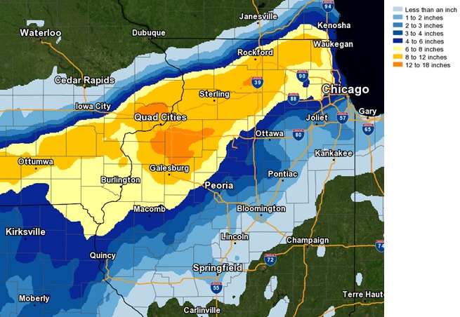
A deep area of low pressure tracking from southeast Kansas during the morning of November 25th to northwest Ohio by the morning of November 26th...brought a wide variety of significant weather to central Illinois. Rain changed to heavy wet snow northwest of the Illinois River by the late afternoon of the 25th, with snow accompanied by thunder at times continuing through the evening. In addition to the snow, strong northwesterly winds developed on the back side of the departing low. Wind gusts peaked in the 45 to 55mph range, with the highest gust of 58mph being recorded during the early morning hours of the 26th 1 mile north of Tilton in Vermilion County. Due to strong winds consistently over 30mph and falling/blowing snow reducing visibilities to less than one quarter of a mile, National Weather Service Lincoln issued a Blizzard Warning across the Illinois River Valley...the first such warning ever issued by the office during the month of November. Once the low departed, conditions gradually improved by the afternoon of the 26th: however, roads remained snow-covered and hazardous across portions of Knox and Stark counties where in excess of 1 foot of snow fell. The highest snowfall totals within the National Weather Service Lincoln County Warning Area (CWA) were 13.4 inches 3 miles east of Rio, 13.2 inches in Altona, and 11.5 inches in Galesburg. Here is a map of the snowfall from the November 25-26, 2018 blizzard:
===============================================================================================================================
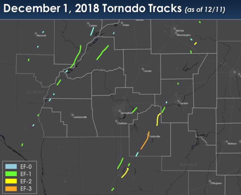
10) December 1 Tornado Outbreak
An historic tornado outbreak occurred across Illinois on December 1st, with a total of 29 tornadoes touching down across the central part of the state. Within the National Weather Service Lincoln County Warning Area (CWA), 20 tornadoes touched down...with the most significant being an EF-3 tornado that tore through the city of Taylorville in Christian County. Despite several communities being directly impacted and experiencing major damage, there were no fatalities reported. Below is a map of all 29 tornado tracks from December 1st.
Here is one of the many tornado pics received via our SWOP network.

For a full review of the event, including complete details from each tornado path...please see:
https://www.weather.gov/ilx/01dec18-outbreak
===============================================================================================================================

