Top 10 Weather Events of 2012
1) Extreme Drought
A persistent upper-level pattern featuring a ridge of high pressure over much of the central and eastern U.S. led to a prolonged period of dry weather across central Illinois this year. After an unusually warm and dry 2011-2012 winter with very little snowfall, precipitation totals continued to be below normal throughout the spring and summer as well. June 2012 featured 0.58 rainfall at the NWS office in Lincoln and only 0.09 in Lawrenceville. July rainfall totals were similar, with Urbana receiving 0.61 and Springfield picking up a mere 0.34. Due to the long stretch of dry weather, yearly rainfall deficits since January 1 reached as much as 8 to 13 inches by the end of July 2012. The drought peaked by early August, when the U.S. Drought Monitor indicated nearly all of central Illinois was in the Extreme Drought (D3) category. Locations along the Indiana border from Edgar County southward to Lawrence County were placed in the worst category of Exceptional Drought (D4).

(August 7, 2012 U.S. Drought Monitor, showing Illinois in peak drought conditions)
The impacts of the drought were far-reaching across central and southeast Illinois. Crop losses were tremendous for both corn and soybeans, reaching an estimated 1.2 billion dollars. Mandatory water restrictions were put into place in a number of communities…including Springfield, Decatur, Mt. Zion, Sherman, Williamsville, Latham, and Sidell. Other areas urged voluntary conservation of the dwindling supply of available water. In addition, many counties across the state instituted burn bans in an effort to prevent wildfires. Remnants of Hurricane Isaac finally brought beneficial rainfall to the region from August 31 through September 3. This was followed up by additional rainfall through the fall that helped significantly ease the drought conditions.
================================================================
2) Extreme Heat in July and August
A strong upper-level ridge of high pressure continued to dominate the weather across the Midwest throughout the summer. This feature kept the prevailing storm track well to the north across southern Canada, with generally hot and dry conditions locked in place further south across Illinois. Due to the lack of significant storm systems tracking through the region, drought conditions worsened in July and August. The increasingly dry ground across central Illinois and upstream across the mid-Mississippi River Valley and southern Plains led to below normal moisture content in the air. The mid-summer sun was then able to heat the dry air more efficiently, resulting in periods of extreme heat. The hottest weather occurred during the month of July, when mean temperatures ranged from 5 to 7 degrees above normal. The NWS office in Lincoln recorded 6 days of 100 degree-plus heat this summer, with the hottest reading of 102 occurring on both July 6 and 7. Here is a table showing heat statistics for selected central Illinois cities.
|
City
|
Number of 100 Degree+ Days
|
Highest Temperature
|
Date(s) of Highest Temperature
|
|
Peoria
|
8
|
104
|
July 7, 23
|
|
Springfield
|
11
|
104
|
July 6, 7
|
|
Lincoln
|
6
|
102
|
July 6, 7
|
|
Urbana
|
10
|
103
|
July 6, 7, 25
|
|
Lawrenceville
|
15
|
107
|
June 29
|
==================================================================================
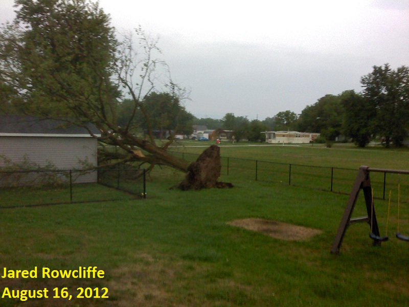
3) August 16: Severe Wind Damage from Pana to Mattoon
Thunderstorms developed along an advancing cold front during the afternoon of August 16. Thanks to cooling aloft associated with an approaching upper-level wave, the airmass became moderately unstable...with Convective Available Potential Energy (CAPE) values ranging from 1500 to 2500J/Kg. In addition, a strengthening low-level jet brought increasing wind energy to the environment. The upper air balloon launched from NWS Lincoln during the evening of August 15 showed winds 2000ft aloft of around 15 mph. These had increased to nearly 50 mph by the morning of August 16. The combination of instability and wind shear led to the development of long-lived thunderstorms along the front during the afternoon and early evening.
The strongest storms formed along a Pana...to Windsor...to Mattoon line, where numerous trees and power lines were downed. The town of Windsor in Shelby County was particularly hard hit, with more than $3 million in damage reported. A SWOP member measured a 78 mph wind gust near the Moultrie/Coles county line as the storms passed, while a 74 mph gust was clocked further south at the Effingham airport. The powerful winds not only downed trees, they also flattened corn fields west of Mattoon. The storms then dropped southeastward, producing sporadic wind damage and heavy rainfall throughout southeast Illinois into early evening.
================================================================
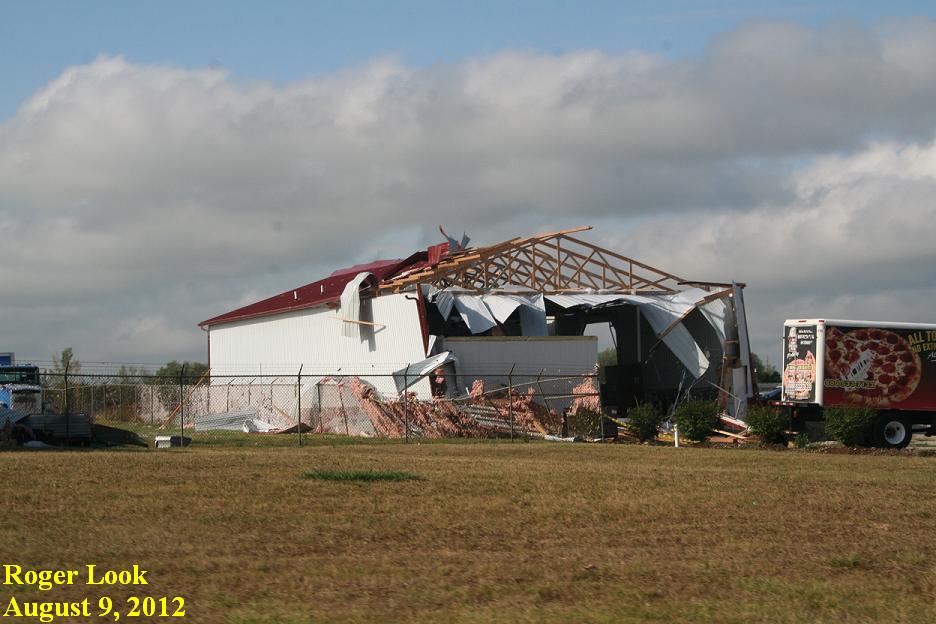
4) August 9: Downburst West and South of Bloomington
A vigorous upper-level disturbance interacting with an approaching cold front triggered scattered severe thunderstorms across north-central Illinois during the afternoon and early evening of August 9. Most of the storms impacted locations along and south of a Peoria...to Bloomington...to Paris line. Downburst winds of 70 to 80 mph produced a wide swath of damage from Danvers southeastward into the southwest side of Bloomington. One of the hardest hit locations along this path was the Apollo Acres subdivision just north of Illinois Route 9, where 159 homes sustained damage. 139 of those homes had awnings or shingles damaged, while 19 suffered minor roof and window damage, and 1 home had one-third of its roof torn off. Total damage in Apollo Acres was around $1 million. Other significant damage occurred along the path of the storm, including numerous downed trees, trailers blown over, and several large metal buildings with doors blown in and roofs torn off. Total damage to 30 businesses along the path was estimated at around $2.5 million. One minor injury was reported, as a car was hit by a wind-blown trailer. In addition to the winds, a large amount of hail accompanied this storm. Wind-driven hail ranging from the size of peas to half dollars created considerable siding and roof damage in the impacted areas.
==================================================================================
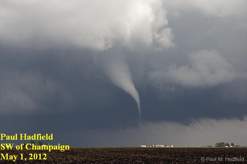
5) May 1: 4 Tornadoes in East-Central Illinois
A warm front lifting northward into the region triggered isolated supercell thunderstorms across east-central Illinois during the afternoon of May 1. Due to adequate atmospheric moisture and strong low-level wind-shear in the immediate vicinity of the boundary, the storms intensified and eventually produced 4 tornadoes. The first tornado briefly touched down at around 4 PM approximately 5.5 miles southeast of Monticello in Piatt County. The storm produced a second tornado in Champaign County about 5 minutes later. This particular tornado touched down 2.5 miles north-northeast of Ivesdale then tracked to 1.5 miles west of Willard Airport. Minor damage to three structures was reported before the tornado dissipated. The parent supercell thunderstorm then went on to produce another brief tornado touchdown in an open field west of Sidney before exiting Champaign County. The final tornado of the day occurred at 5:18 PM just southeast of Tilton in Vermilion County. It severely damaged a garage and threw debris into several campers and trailers before lifting. In addition to the tornadoes, very large hail ranging from 1 to 2 inches in diameter occurred from St. Joseph in Champaign County to near Danville in Vermilion County. The 4 tornadoes that occurred across east-central Illinois on May 1 were the first confirmed tornadoes across NWS Lincoln’s forecast area in 2012.
================================================================
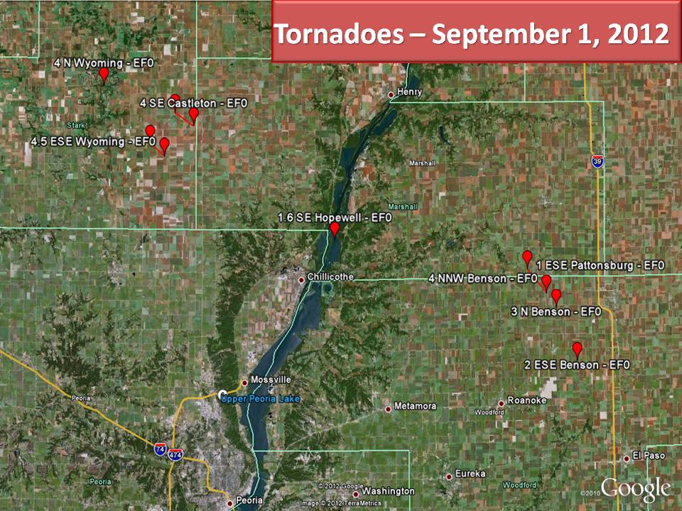
6) August 31-September 1: Hurricane Isaac Tornadoes
The remnants of Hurricane Isaac moved northeastward across central Illinois on August 31 and September 1, producing widespread showers. As the parent low associated with the system neared, low-level wind-shear increased across the area. As is often the case with landfalling tropical systems, enough wind-shear was generated within the lowest 1000 feet of the atmosphere to produce several weak short-lived tornadoes. A total of 9 tornadoes touched down across central Illinois as the remnants of Isaac moved through.
Two tornadoes occurred in conjunction with a band of showers during the evening of August 31 across Morgan County. The first touched down near Franklin and produced structural damage to a house, mobile home, and an auto repair shop. This tornado injured one person and was rated an EF1, with estimated wind speeds of around 90 mph. The second tornado briefly touched down in a field 3 miles west-northwest of Franklin, then dissipated in less than one minute.
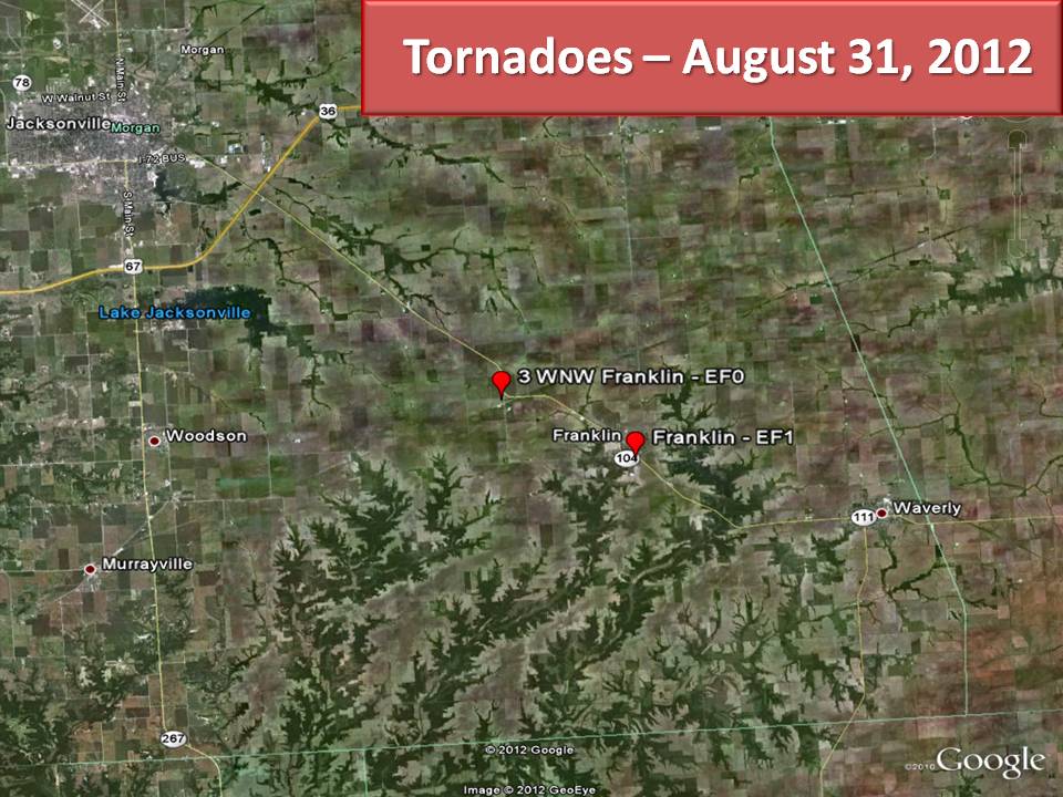
Seven additional tornadoes were spawned further north near a stationary frontal boundary across Woodford, Marshall, and Stark counties on September 1. These tornadoes were all quite weak (EF0) and were only on the ground for a matter of minutes. Most of them touched down in farm fields and produced no damage. The exception was with a tornado that formed 4 miles north-northwest of Benson in Woodford County. This particular storm tracked northwestward for about 1.5 miles, doing minor damage to the tin roof of a farm building before dissipating.
==================================================================================
7) August 31-September 3: Beneficial Rainfall from Hurricane Isaac
After suffering through months of crippling drought resulting in yearly rainfall deficits as much as 13 inches, widespread beneficial rains finally returned to central Illinois in early September. As the remnants of Hurricane Isaac tracked slowly northward then eastward across the region, moderate to heavy showers soaked the parched soils. By the time the showers ended on September 3, storm total rainfall amounts of 2 to 5 inches were common. Pockets of even higher totals in excess of 5 inches were noted around the area, with a SWOP member in Taylorville recording the highest observed amount of 5.93. The rainfall from Isaac was the first important step in reducing and eventually eradicating the ongoing drought.
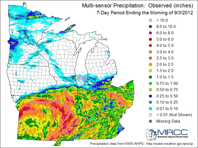
(Rainfall map courtesy of the Midwestern Regional Climate Center)
========================================================================
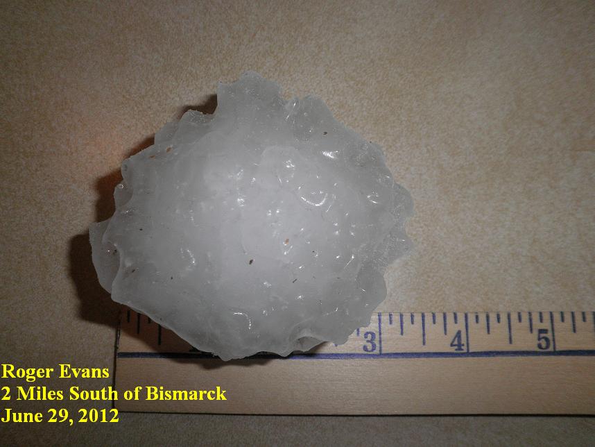
8) June 29: Baseball-Sized Hail in Vermilion County
A large complex of severe thunderstorms tracked across northern Illinois into north-central Indiana during the late morning and early afternoon of June 29. The storms developed and moved along a stationary frontal boundary draped along the I-80 corridor. To the south of the front, a very hot and unstable airmass was in place across central Illinois, characterized by temperatures of around 100 degrees and Convective Available Potential Energy (CAPE) values exceeding 3500 J/kg. As the storms tracked east-southeast along the front, a few cells were able to develop on the southwest fringes of the complex across Vermilion County. Thanks to the highly unstable feed of air from the south, extremely strong updrafts within the storms were able to support very large hail northwest of Danville. The largest observed hailstone was an amazing 3” in diameter, which is slightly bigger than a baseball! Here is a picture of that stone captured by one of our SWOP observers.
================================================================
9) March 2: Large Hail in East-Central Illinois
A powerful storm system triggered a widespread outbreak of severe weather across the Ohio and Tennessee River Valleys on Friday, March 2nd. Numerous reports of tornadoes, large hail, and damaging winds were reported across this area. Further northwest, a variety of less severe weather occurred in central Illinois…including hail, strong winds, and locally heavy downpours.
Low pressure tracking from southern Missouri during the morning of March 2nd to eastern Michigan by early evening was the main culprit of all the wild weather across the region. As the low moved northward, warm and moist air riding up and over an advancing warm front triggered scattered strong to severe thunderstorms across east-central Illinois during the morning hours. Many of these cells produced hail, with the largest stones being observed in Cumberland County…where our Neoga SWOP reported ping-pong-sized hail and an observer 2 miles northeast of Neoga picked up golf ball-sized hail. Other storms further north into the cool sector of the system produced large quantities of very small hail. Numerous observers across Coles, Champaign, Edgar, and Vermilion counties reported pea-sized hail nearly covering the ground after the storms passed.
================================================================
10) Record Warm March
Thanks to a persistent upper-level ridge of high pressure over the Great Lakes and Midwest, unseasonably warm weather was observed during the month of March. The pattern became even more pronounced from March 14 through 21 when the ridge strengthened further and the prevailing polar jet stream lifted well northward into Canada. With southerly winds and ample sunshine, a summer-like regime featuring daily high temperatures in the upper 70s and lower 80s took hold. This unprecedented early spring warmth resulted in numerous record high temperatures across the area. In addition, many locations experienced their earliest 80-degree day ever in a calendar year. The NWS office in Lincoln recorded a whopping 6 days at or above the 80 degree mark during the month of March. Despite a cool-down by the end of the month, average temperatures were around 15 degrees above normal, which made March 2012 warmer than a typical April across central Illinois!

