November 20-21, 2015
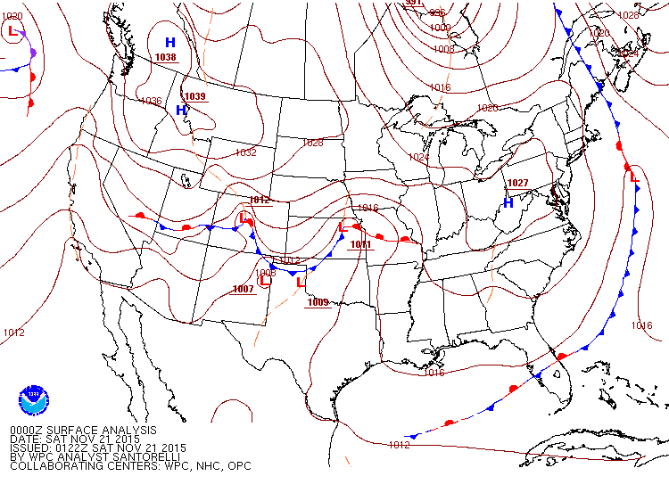
An early season winter storm brought a mix of rain and snow to central Illinois from the late evening of November 20th through the afternoon of November 21st. Most of the snow occurred during the morning of the 21st when colder air began filtering into the region behind the departing system. Surface analysis from 6pm November 20th showed a 1011mb low pressure system just west of Kansas City, with a stationary frontal boundary extending eastward into southern Illinois. Light precipitation was beginning to develop north of the low into west-central Illinois at that time: however, it's eastward progression was being inhibited by a very dry airmass in place across the area. An upper air balloon launched by NWS Lincoln during the evening of the 20th showed the dry air quite clearly. Note how far apart the temperature and dewpoint lines are on the upper air sounding below. This indicates the presence of very dry air. The lines get much closer together at about 9,000ft aloft, indicating a mid-level cloud deck.
 |
 |
Surface Weather Map 11/20/15 at 6 PM NWS Lincoln Upper Air Sounding 11/20/15 at 6 PM
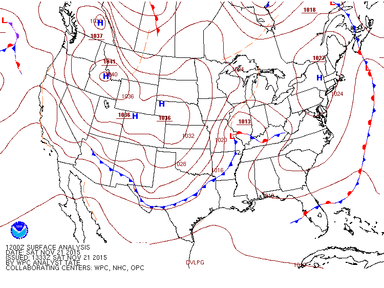
As the airmass moistened from the top-down and the low pressure approached from the southwest, precipitation spread across much of north-central Illinois during the late evening. Surface temperatures were initially warm enough to support mostly rain: however, ample evaporational cooling taking place in the dry layer helped lower temperatures sufficiently to change the rain over to snow northwest of the Illinois River by late evening. The atmosphere remained warm enough for rain further south and east until the morning of November 21st when winds began to switch to northerly as the low tracked just south of the I-72 corridor. The surface weather map from 6am November 21st showed the low near St. Louis, while the morning upper air sounding from NWS Lincoln showed the previous dry layer had completely saturated. Note the blue line on the sounding below indicating the freezing layer. There was still a layer of above freezing air from the surface up to about 1400ft aloft in Lincoln at the time of the balloon launch, which was just enough to keep the precipitation all rain. Shortly afterwards as northerly surface winds began to bring colder air into the area, the rain changed over to snow in Lincoln at about 7am.
 |
.jpg) |
Surface Weather Map 11/21/15 at 6 AM NWS Lincoln Upper Air Sounding 11/21/15 at 6 AM
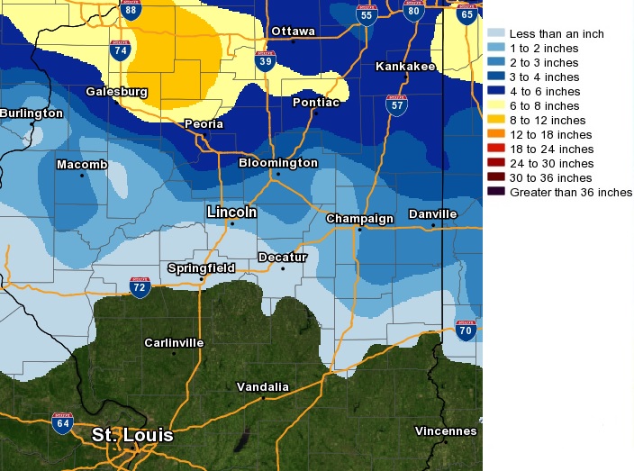
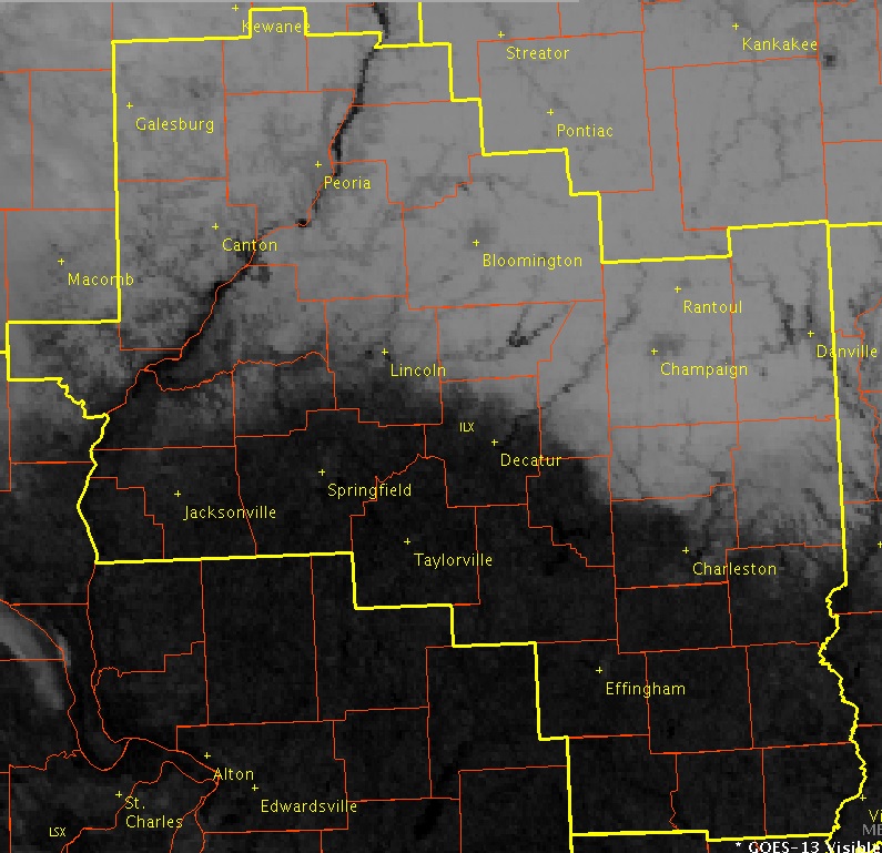
As the low tracked to near Terre Haute, Indiana, the rain/snow line progressed steadily southward. Weather observers as far south as Effingham, Jasper, and Crawford counties reported a few flurries as the precipitation came to an end: however, little in the way of accumulation occurred that far south. Meanwhile further north, the snow gradually came to an end from west to east across the area by the afternoon of November 21st. Snowfall totals were quite impressive across north-central Illinois, with 1 to 2 inches occurring along a Rushville...to Lincoln...to Paris line....2 to 4 inches along a Canton...to Bloomington...to Danville line...4 to 6 inches along a Peoria to Watseka line...and as much as 8 to 10 inches along and northwest of a Galesburg to Bradford line. The highest amount measured within the SWOP network was a whopping 7.8 inches in the town of Knoxville in Knox County: however, other weather observers a bit further north in Knox County reported as much as 10.0 inches in Altona and Galva. Once the snow ended, strong northwesterly winds gusting to between 25 and 35 mph created some blowing and drifting along and north of the I-74 corridor during the late afternoon and evening. Once skies cleared and winds diminshed after dark, the coldest temperatures thus far this season were reported by the morning of November 22nd when many observers across snow-covered north-central Illinois recorded overnight low temperatures in the single digits. Below is an image of the snow cover as seen from visible satellite imagery from the morning of November 22nd. The white color on the image is not clouds, but is instead snow cover reflecting sunlight back to the satellite.
Here is a map of the November 20-21 snowfall event: