September 27-October 2, 2019
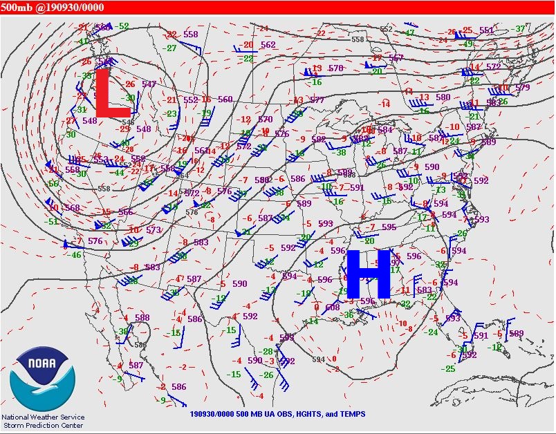
An unusual weather pattern more characteristic of mid-summer than early fall developed across the Midwest from September 27th through October 2nd. A strong upper-level ridge of high pressure expanded across the Deep South, building as far north as central Illinois. An impressive dome of record-setting heat developed beneath the high as afternoon high temperatures soared into the upper 90s to near 100 degrees from parts of Kentucky southward to the Gulf Coast. Meanwhile further north into Illinois, readings climbed into the upper 80s and lower 90s. Springfield tied their previous record high of 91 degrees on both September 27th and October 1st...while Lincoln tied their old record of 91 on October 1st. In addition to the heat, unseasonably high dewpoints in the upper 60s and lower 70s created heat index readings well into the 90s. Below is an upper-level map depicting the impressive high centered over the southern U.S. on the evening of Sunday, September 29th.
HIGH TEMPERATURES (red numbers indicate record values)
| DATE | PEORIA | SPRINGFIELD | LINCOLN |
| 9/27 | 80 | 91 | 91 |
| 9/28 | 78 | 86 | 83 |
| 9/29 | 77 | 87 | 86 |
| 9/30 | 88 | 89 | 90 |
| 10/1 | 88 | 91 | 91 |
| 10/2 | 81 | 88 | 84 |
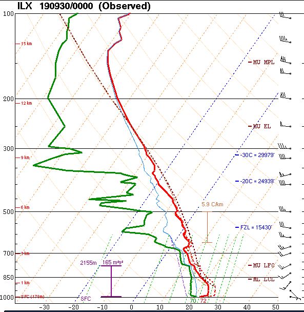
In addition to the heat, several rounds of thunderstorms brought torrential rainfall to parts of central Illinois. Due to consistent deep-layer southwesterly flow around the upper high, the atmosphere became laden with moisture. An upper air balloon launched by NWS Lincoln during the evening of Sunday, September 29th showed a precipitable water value of 1.71...which is in the 99th percentile for this time of year. Precipitable water is a measure of the total amount of water contained within the depth of the atmosphere and is a good indicator of the potential for heavy rain. Note how close the temperature (red line) and dewpoint (green line) are through a good portion of the atmospheric column in the image below. Substantial drying isn't noted until a height of about 8km (26,000ft).
SUNDAY, SEPTEMBER 29 EVENING UPPER AIR SOUNDING
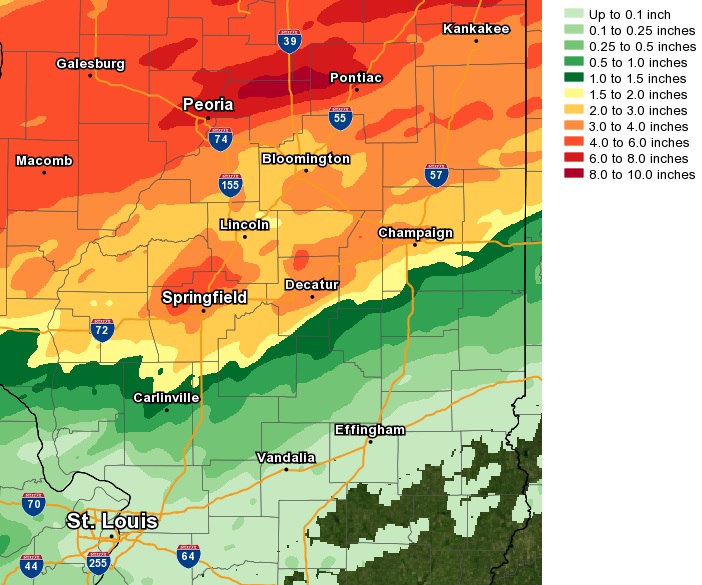
With the upper high over the Deep South holding firm, most of the convection that developed from Friday, September 27th through Monday, September 30th was focused north of a Rushville to Bloomington line. As the high slowly weakened, a cold front eventually pushed through Illinois and brought showers and thunderstorms further southeastward across the remainder of the region. Here is a map of the total rainfall from September 27th through October 2nd. All locations along and north of a Taylorville to Danville line saw greater than 1 inch...with a maximum of 6 to 10 inches noted from eastern Peoria County across northern Woodford and southern Marshall counties. Peoria set a new daily rainfall record for September 27th when a whopping 3.14 was observed. Springfield established a new daily rainfall record just a couple of days later on September 29th when 3.30 occurred.
SEPTEMBER 27-OCTOBER 2 RAINFALL
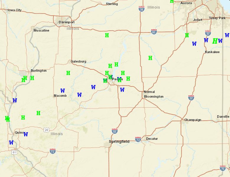
There were also a couple rounds of severe weather during this unseasonably hot and wet period. On Friday, September 27th several reports of damaging wind gusts and large hail were received along a Quincy...to Peoria...to Kankakee line. (Blue W denotes wind damage and Green H represents large hail on the map below).
SEPTEMBER 27 SEVERE WEATHER REPORTS
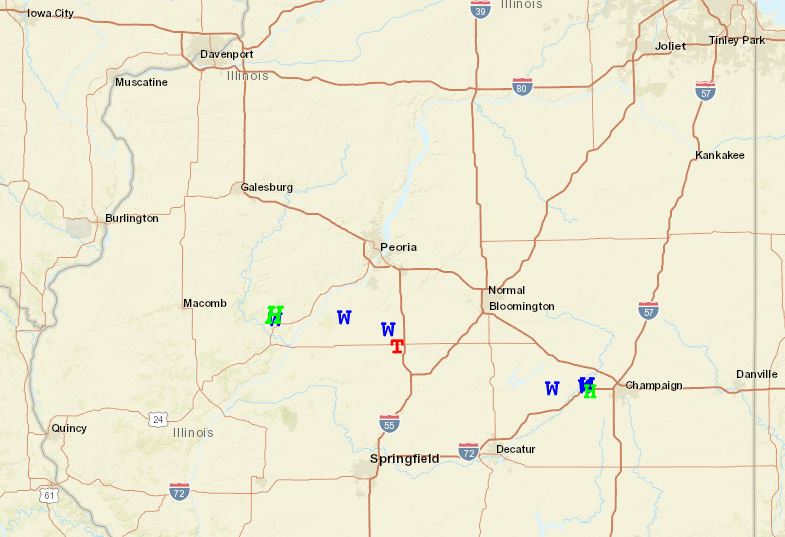
Then on Sunday, September 29th, scattered severe thunderstorms brought large hail and damaging wind gusts from just east of Macomb eastward to near Champaign. Hail as large as tennis balls was reported just north of Lewistown in Fulton County and an EF-0 tornado touched down near Emden in northern Logan County. (RED T denotes tornado on the map below.)
SEPTEMBER 29 SEVERE WEATHER REPORTS