June 25-27, 2011
A series of thunderstorm complexes affected central and southeast Illinois from Saturday, June 25, into Monday morning, June 27. These Mesoscale Convective Systems (MCSs) formed on the northern fringe of a hot air dome which extended across the southern and central Plains. On the periphery of this hot and humid airmass, thunderstorms repeatedly formed north of a warm front as mid level disturbances tracked east across the Midwest. A strong low level jet stream coming in from the southwest provided additional warm, moist air to feed the storms.
The first batch of MCS activity affected west-central Illinois on Saturday morning and afternoon. Extremely high rainfall rates (as high as 2 inches per hour) were observed with some of these storms. This led to several instances of flash flooding in Scott county. By Saturday evening the low level jet aided another round of heavy thunderstorms which formed in west central Illinois and tracked into the southeast part of the state after midnight. Isolated reports of hail up to the size of quarters, and wind damage were reported with these storms from the Jacksonville to Springfield areas. As the system progressed southeast, very high rainfall rates produced flash flooding in Clay and Effingham counties.
On Sunday evening the same setup was in place, and the first round of storms tracked across the central part of the state around midnight. Isolated wind damage and hail from penny to golf ball size occurred in Peoria, Tazewell, Logan, and McLean counties. Quickly on the heels of this complex, a large and well organized squall line with widespread damaging winds blasted east from Iowa and Missouri at around 60 mph. This system affected all of central and southeast Illinois between 2 and 5 AM Monday morning. Winds of 40 to 50 mph were common along the leading edge of the storms, with isolated damaging downburst winds in excess of 60 mph. Hail up to the size of nickels occurred with these storms. Again, very high rain fall rates led to another round of flash flooding across much of the area.
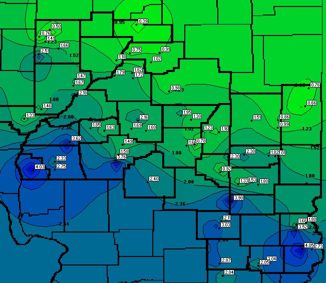
A cold front finally began to push across the state on Monday evening. Thanks in part to the after-effects of the earlier convection, severe storms did not develop ahead of the front. Below is a map of rainfall totals submitted by the SWOP network.