May 7, 2016
An approaching cold front triggered a round of strong to severe thunderstorms across south-central Illinois during the afternoon and early evening of May 7th. The storms tracked along and south of a Quincy...to Effingham...to Robinson line between 4 pm and 7 pm. Strong winds of 60 to 70 mph were the primary impact: however, a few reports of hail were also received.
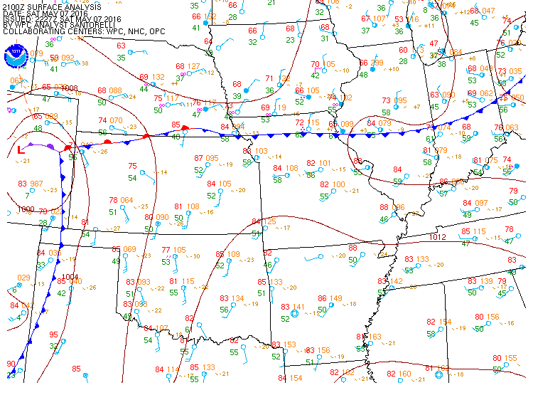
Surface analysis from 21z/4pm on May 7th showed a cold front sinking southward through central Illinois, with the boundary roughly extending from Quincy to just north of Terre Haute, Indiana. The airmass to the south of the boundary was quite warm, but not particularly humid...as sprawling high pressure along the Gulf Coast limited the northward return flow of moisture. While temperatures were in the middle 80s, surface dewpoints were only in the middle to upper 50s. This kept instability parameters on the modest side, with Convective Available Potential Energy (CAPE) values peaking at 1500-1600J/kg. Meanwhile, an upper-level trough digging into the Great Lakes provided a small boost in wind shear, resulting in 0-6km bulk shear values reaching 40-50kt. The combination of modest instability and wind shear in the vicinity of the surface cold front was just enough to set off a few clusters of strong to severe thunderstorms. Here is the 4pm May 7th surface weather map.
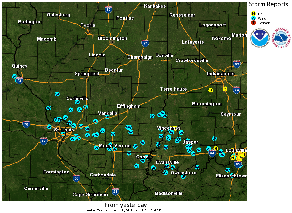
Thunderstorms first began to initiate along and south of the front across southern Iowa and northern Missouri around midday, then developed and spread southeastward across south-central Illinois as the day progressed. The first severe weather report came in just south of Quincy shortly before 4 pm as several clusters of strong storms crossed the Mississippi River into west-central Illinois. These storms continued to track southeastward and eventually congealed into a linear structure as they passed between Springfield and St. Louis. Numerous reports of damaging wind gusts of 60 to 70 mph were received as the storms pushed toward southeast Illinois. Meanwhile...additional scattered thunderstorms began to develop further east along the front. One cell became severe along the Clark/Crawford County line as it dropped southeastwrad toward the Wabash River. This strom produced 60-70 mph winds and copious amounts of small hail. An observer 1 mile south of Palestine in Crawford County reported estimated 60 mph winds and the ground covered by pea to marble-sized hailstones. Trees and powerlines were blown down in Palestine and just northeast of Robinson. In addition, a barn was heavily damaged and trees and power lines were blown down about 2 miles east of Trimble. Meanwhile, the main line of thunderstorms approached from the west, sweeping across locations along and south of an Effingham to Robinson line. The strongest winds impacted portions of Clay, Richland, and Lawrence counties. In Clay County, large tree limbs were blown down 3 miles southwest of Louisville and numerous tree limbs were knocked down and shingles were blown off a house in Flora. Further east, an observer reported a tree down in Parkersburg in Richland County and several tree branches and power lines were blown down in Lawrenceville in Lawrence County. The storms then exited into Indiana at around 7 pm. Below is a map of all severe weather reports received on May 7th.