April 19, 2011
An initial round of convection affected parts of central and southeast Illinois during the morning of April 19th. This activity formed north of a warm front, as a low level jet stream brought in unstable air a few thousand feet aloft. Hail ranging from pea to quarter-sized along with locally heavy rainfall of 1-2" affected much of the area between 4 and 9 AM.
By mid afternoon, a strong warm front shifted north to near the I-72 corridor. Low clouds and northeast winds north of the boundary held temperatures in the 40s, while south of the front sunny skies and southerly winds pushed temperatures into the 70s with dew points in the 60s. A high of 46 in Peoria and 80 in Springfield showed the sharp contrast across this front! Strong low level wind shear in the vicinity of the boundary provided a key ingredient for a rotating supercell to form in east central Missouri around 3 PM. This storm tracked eastward, periodically dropping up to baseball-sized hail and cyclic tornadoes. The cell skirted the southwest fringe of the ILX county warning area with hail and damaging winds affecting far southern Scott, Morgan, and Sangamon counties. The southern part of the storm produced an EF3 tornado that caused significant damage in Girard. Other storms developed during this time north of the warm front and produced copious amounts of pea to nickel-sized hail northeast along the Illinois River Valley. Heavy rain with these storms also produced localized flash flooding.
As the main supercell tracked into Christian county, the circulation broadened and a more linear thunderstorm structure began to form. The system quickly grew upscale into a QLCS (quasi-linear convective system) which produced large hail, widespread damaging straight line winds, and possible brief tornadic spin ups along the leading edge. Between 7 and 10 PM, this line of storms tracked through eastern Illinois, downing trees and power lines and causing localized structural damage. Very heavy rain rates also produced more localized flash flooding.
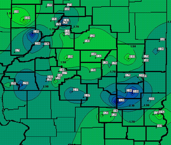
Below is a map of SWOP rainfall reports from April 19th.