April 2, 2025
An area of low pressure tracked from southeastern Nebraska during the morning of April 2nd to western Wisconsin by evening...triggering two rounds of convection across central Illinois.
Round number one occurred during the morning when a line of thunderstorms along the trailing cold front pushed into the Illinois River Valley. These storms were generally sub-severe: however, one cell produced a downburst with estimated winds in excess of 70mph across parts of Logan County...downing a few trees, tearing the roof off a business, and flipping 3 semis in and near Lincoln.
Round number 2 materialized by early afternoon as cells re-developed along an outflow boundary from the morning convection along the I-55 corridor. These storms tapped into a moderately unstable and highly sheared environment and quickly became severe. Numerous reports of wind damage and hail were received as they congealed into a line and pushed eastward across I-57 by early evening.
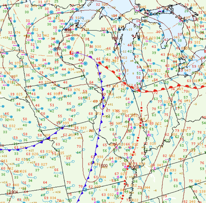
Surface analysis from 7pm April 2nd showed a squall line (denoted by the red dashes and dots on the map below) from near Paris, Illinois southwestward into the bootheel of Missouri. A warm and humid airmass existed ahead of the line across the Ohio River Valley where temperatures were in the upper 70s and lower 80s and dewpoints were in the lower to middle 60s.
SURFACE MAP 7PM CDT APRIL 2
Given the warm and humid conditions, the atmosphere became moderately unstable during the afternoon. Mesoanalysis from 2PM revealed Mixed Layer Convective Available Potential Energy (MLCAPE) values in excess of 1500J/kg along and south of a Springfield to Paris line.
MIXED LAYER CAPE 2PM CDT APRIL 2

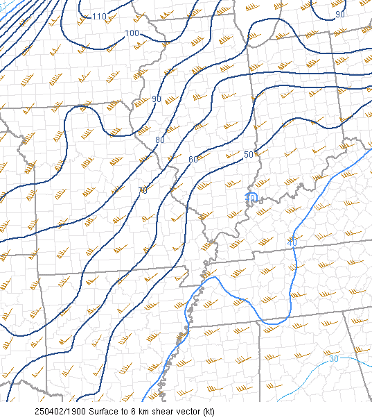
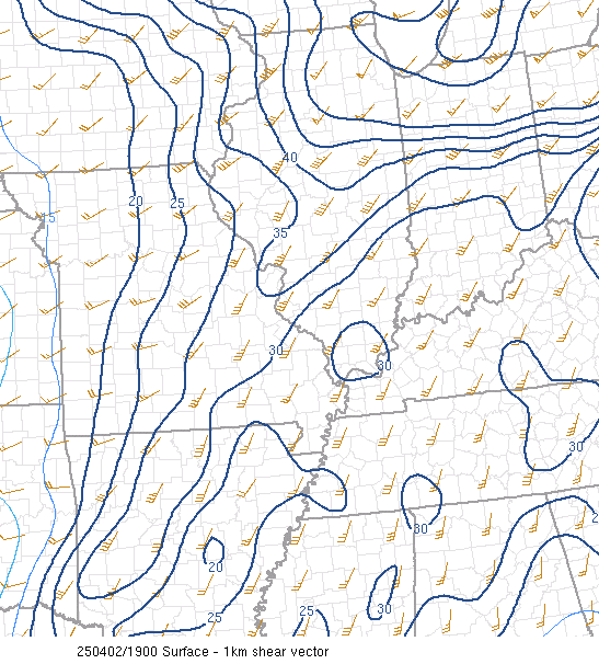
A powerful jet streak contributed to high values of wind shear. 0-6km bulk shear ranged from 50-70kt within the zone of greatest instability...while 0-1km shear reached 30-40kt. Both values were highly supportive of supercell thunderstorm development.
0-6KM SHEAR 2PM CDT APRIL 2
0-1KM SHEAR 2PM CDT APRIL 2
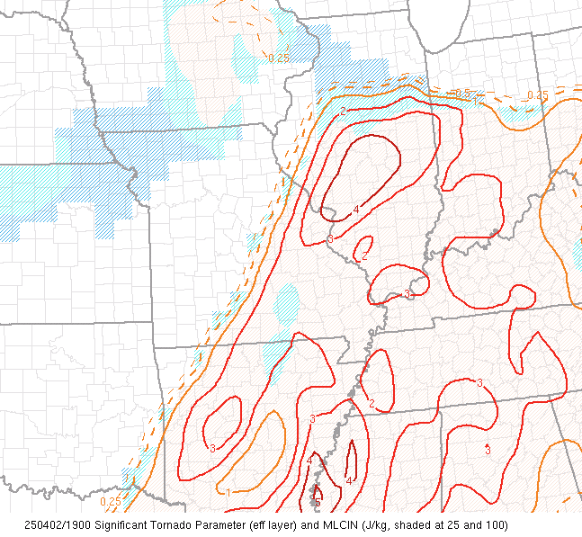
The Significant Tornado Parameter (STP), which combines a number of variables in order to provide an estimate of possible EF-2 or stronger tornadoes was analyzed at greater than 4 across a good portion of south-central Illinois during the early afternoon. Values in excess of 1 indicate an increasing potential for significant tornadoes.
SIGNIFICANT TORNADO PARAMETER (STP) 2PM CDT APRIL 2
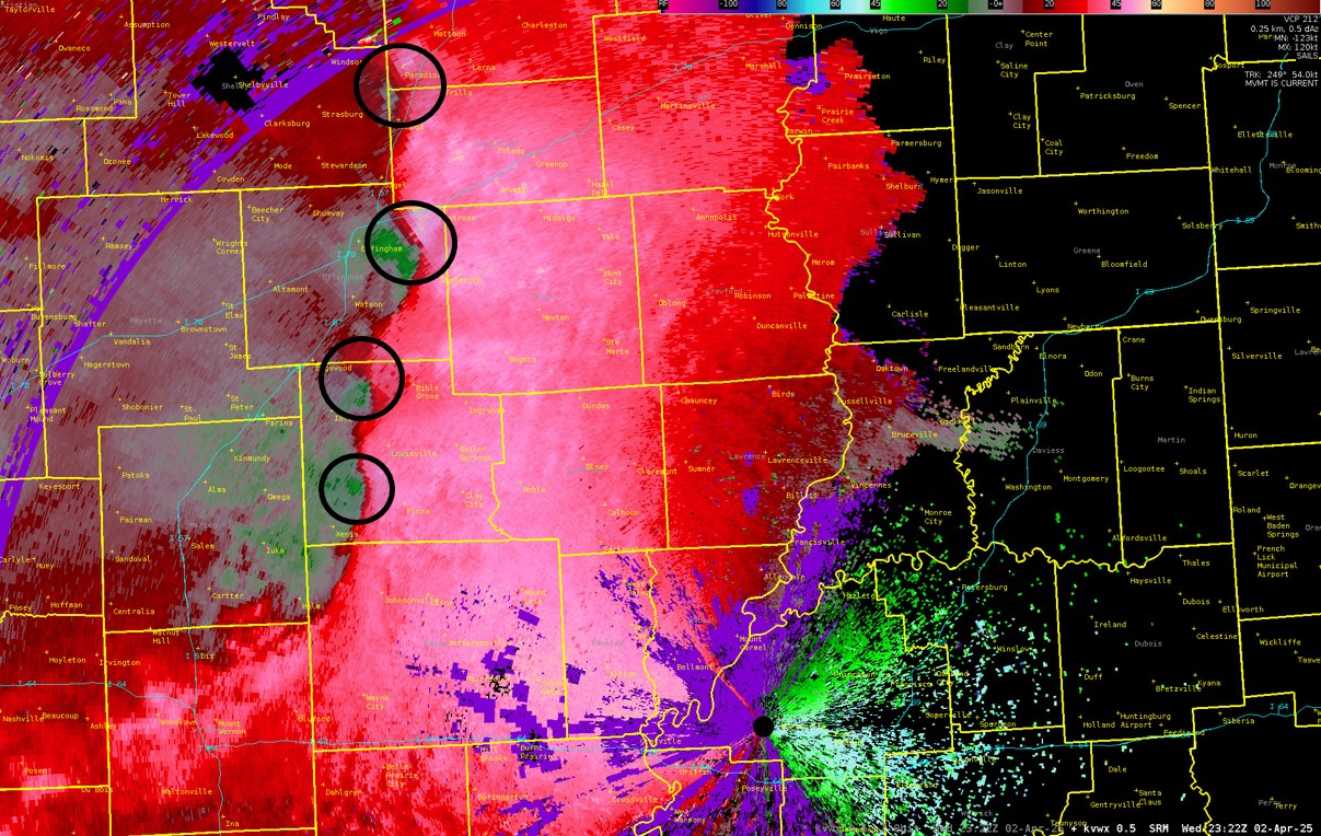
As the line of convection that formed along I-55 during the early afternoon pushed eastward, it encountered the favorable storm environment outlined above. While wind damage and hail reports were received along the entire line, the southern portion became dominant by late afternoon and early evening. This is likely due to the greater instability, richer deep-layer moisture, and lower Lifting Condensation Levels (LCLs) further south. Numerous kinks and notches developed along the leading edge of the line...particularly along and south of I-70. The image below shows Storm Relative Velocity (SRV) as seen from the Evansville Doppler radar at 6:22PM CDT. The red colors indicate parcels moving away from the radar beam, while the green shows movement toward the radar. When high reflectivity is present and the two colors are side-by-side, this is known as a velocity couplet. This particular scan shows numerous couplets (black circles) along the line, indicating rotation and possible tornadic development across portions of Cumberland, Effingham, and Clay counties. NWS Lincoln will be surveying these locations to determine if any tornadoes touched down...and the results will be shared on our webpage when completed.
STORM RELATIVE VELOCITY (SRV) 6:22PM CDT APRIL 2
Here is a look at preliminary storm reports across the area from April 2nd. W= wind damage, H=large hail


