February 28, 2017
A powerful late winter storm system brought severe weather to portions of central and southeast Illinois on February 28th. An EF-3 tornado with estimated winds of 150-160mph tracked through the town of Washburn in Woodford County, damaging several homes and outbuildings and downing numerous trees. Elsewhere around the area, thunderstorm winds gusted as high as 60-65mph and hail as large as golfballs was reported.
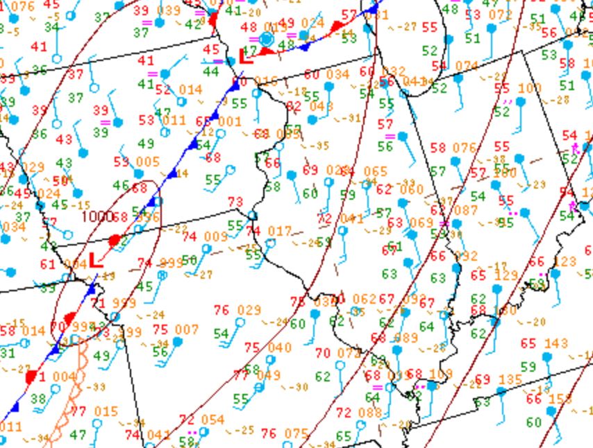
The 21z/3pm surface map from February 28th showed a cold front extending from southern Wisconsin southwestward to Kansas...with a 1000mb low pressure along the boundary over northwest Missouri. Ahead of the front, strong southerly winds were transporting unseasonably warm and humid conditions into central Illinois. 3pm temperatures were well into the 60s, with Springfield reporting 72 degrees. Thanks to these near record high temperatures and dewpoints surging into the upper 50s and lower 60s, Convective Available Potential Energy (CAPE) values exceeded 1500J/kg across Missouri and the western half of Illinois by late afternoon. In addition, a strong mid-level jet streak enhanced 0-6km wind shear to an impressive 60-70kt. While the airmass within the warm sector was initially capped, an approaching upper wave helped weaken the cap and set the stage for strong to severe thunderstorms into the evening.
3pm surface map
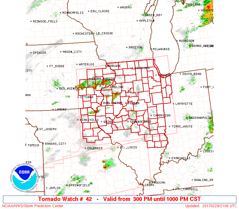
While the main surface front was still well to the west across Iowa and Missouri, a weak trough axis extended eastward just north of the I-74 corridor by late afternoon. This boundary served to further enhance low-level wind shear as winds to the north of it were from the south-southeast, while winds to the south were south-southwest. With this area of greater wind shear becoming evident, the Storm Prediction Center (SPC) in coordination with area NWS offices issued Tornado Watch 42 valid from 3pm to 10pm. The immediate concern was with the trough along and north of a Canton to Bloomington line: however, the decision was made to extend the watch southward to cover the entire NWS Lincoln County Warning Area (CWA) in order to catch isolated cells that several high-resolution models were forecasting to develop within the warm sector across south-central and southeast Illinois.
Tornado Watch #42
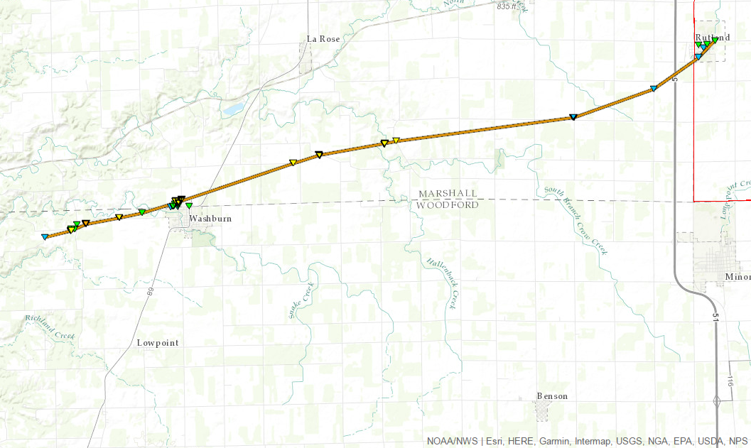
Shortly after the watch was issued, scattered thunderstorm cells began to strengthen in the vicinity of the trough axis across far eastern Iowa into west-central Illinois. The first Severe Thunderstorm Warning issued by NWS Lincoln went out at 3:35PM for northern Stark County...with the first Tornado Warning coming at 5:05PM for northeast Peoria, northwest Woodford, and southwest Marshall counties. This particular warning would later be extended to cover much of northern Woodford County through 6pm. Based on results of an NWS damage survey conducted on March 1st, a tornado touched down 3.5 miles west of Washburn in northern Woodford County at 5:26pm. The tornado quickly increased in intensity and width, peaking at EF-3 status and approximately 600 yards in width. It severely damaged 8 homes in Washburn, then tracked east-northeast across southern Marshall County before eventually crossing into far southern LaSalle County and dissipating near the town of Rutland.
Washburn tornado track map
Once this initial cell tracked out of the NWS Lincoln CWA, other rotating thunderstorm cells developed and had to be closely monitored for the next couple of hours: however, no other tornadoes occurred. Meanwhile further south into the warm sector, widely scattered strong to severe thunderstorms developed, including one that produced golfball-sized hail in Shelbyville and another that dropped half-dollar-sized hail south of Xenia in Clay Clounty. After a brief lull in the storms, convection began developing further west along the advancing cold front by mid-evening. This activity congealed into a squall line as it tracked through the Illinois River Valley during the late evening, across the I-55 corridor around midnight, and eastward to the Indiana border by 1am. Winds with the line were generally 40-60mph, with hail ranging from pea to nickel-sized. Another wave of storms eventually pushed out of southeast Missouri and tracked across southeast Illinois later in the night, producing gusty 40-60mph winds, but producing little in the way of damage in the NWS Lincoln CWA.
February 28th Severe Weather Reports


