February 20, 2014
A powerful late winter storm system brought much warmer conditions and severe weather to parts of central Illinois on Thursday, February 20th. Damage surveys conducted by NWS Lincoln showed a total of 7 tornadoes touched down across the area during the mid to late afternoon hours. In addition, rainfall combined with rapid snow melt led to widespread flooding north of the I-70 corridor.
A 991mb low pressure over eastern Kansas during the morning of February 20th rapidly deepened to 983mb as it tracked into southwestern Wisconsin by evening. As the low passed to the northwest of central Illinois, southerly winds pulled much warmer air northward into the area, resulting in high temperatures soaring well into the 50s and 60s. The warm/moist air flowing over the cold/snow-covered ground led to the development of widespread dense fog along and north of a Canton to Bloomington-Normal line during the late morning and afternoon. Visibilities across this part of the state were reduced to near zero at times before southerly winds increased sufficiently to scour out the fog by late afternoon.
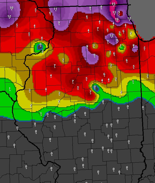
As a trailing cold front approached from the west, scattered thunderstorms developed across northern and central Missouri by early afternoon. The big question of the day was how far north into central Illinois could these strong to potentially severe thunderstorms survive, especially given the lingering snow cover north of the I-72 corridor. Here is a map showing the measured snow depth as of 7 AM February 21st. This is a good approximation as to where snow cover existed as the storms came into central Illinois during the afternoon of the 20th. Note that at least 1 inch of snow remained on the ground along and north of a Quincy...to Bloomington...to Hoopeston line, with as much as 5 to 7 inches from the Peoria area northward.
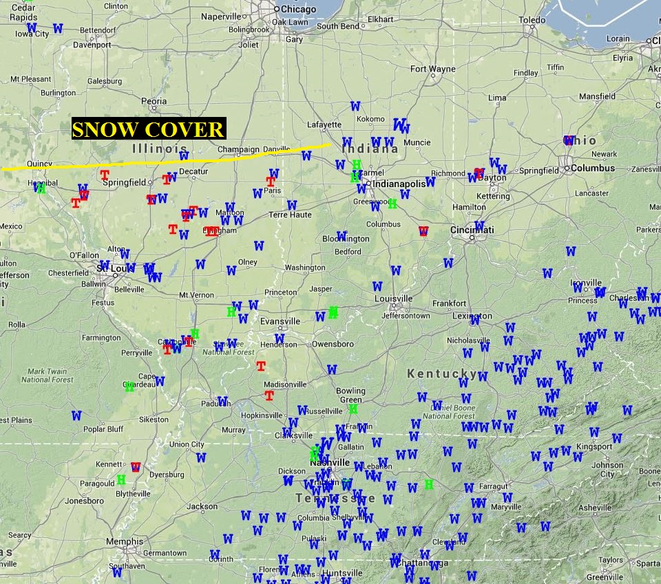
The storms only had modest instability to work with, but plenty of low-level wind shear in the vicinity of the rapidly strengthening surface low to the west. As they tracked northeastward, several of the cells began to rotate and tornado warnings were subsequently issued. The first confirmed tornado across NWS Lincoln's County Warning Area (CWA) occurred 2.5 miles northwest of Concord in Morgan County shortly before 3 PM. No damage was reported with this short-lived weak tornado as it tracked across rural areas of Morgan and Cass counties. Later in the afternoon, two tornadoes touched down in Sangamon County, including an EF-1 tornado 4 miles south of Mechanicsburg that damaged numerous outbuildings and the roofs of several homes and flipped over a trailer. The strongest tornado of the day touched down about 3 miles south of Pana in Christian County at 4:20 PM then tracked northeastward to just north of Tower Hill in Shelby County. It created EF-2 damage at times, including major roof damage to a house 3 miles northwest of Tower Hill. Other tornadoes occurred in Effingham and Edgar counties: however, they were short-lived and did minimal damage. Here is a map of all severe weather reports received across the Midwest on February 20th (T= tornado, W= severe wind gust, H=hail). Note that very few severe storms occurred north of the yellow line marking the southern extent of the significant snow cover as seen on the previous image. It is apparent that despite strong wind shear and upper-level dynamics, the snow cover acted to stabilize the atmosphere enough to prevent the severe weather from spreading north of the I-72 corridor.
Once the cold front exited central Illinois during the evening of February 20th, very strong westerly winds developed due to an intense pressure gradient between the deep low over southwestern Wisconsin and a high over the Plains. Winds gusted to between 45 and 55 mph at times, with Capital Airport in Springfield recording a peak wind gust of 63 mph.
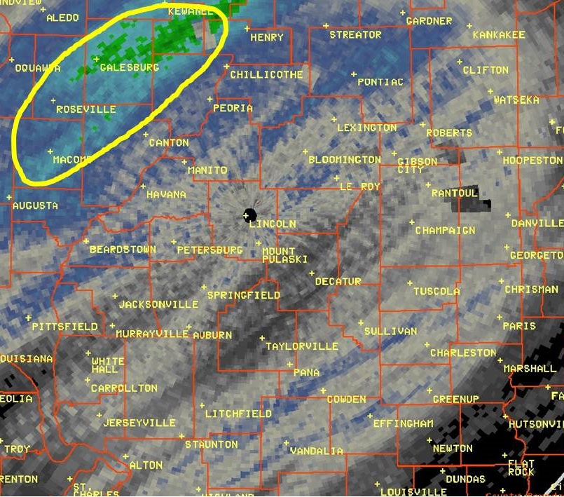
In addition to the tornadoes and very strong winds, flooding became a major issue across the area as well. Here is a map of Doppler estimated rainfall covering the period from the evening of February 19th through the evening of February 20th. Most locations received between one quarter and three quarters of an inch of rainfall: however, several bands of enhanced rainfall due to stronger storms can be seen on the image. Note the green colors circled northwest of the Illinois River. This area received over 2 inches of rain, mainly from several rounds of showers and thunderstorms during the night of February 19th. This rain exacerbated the worsening water problem caused by the rapid snow melt. As a result, many fields and low-lying areas flooded. Numerous creeks and streams have since spilled out of their banks, with some of the worst flooding taking place along the Spoon River in Knox and Fulton counties where the heaviest rainfall occurred.