February 4-5, 2014
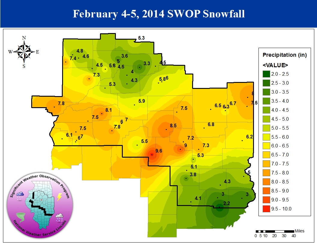
A powerful winter storm system impacted central and southeast Illinois on February 4th into the 5th, bringing widespread snow and gusty winds. The highest snowfall totals were concentrated along the I-72 corridor from Jacksonville...to Decatur...to Danvile, where amounts of 6 to 8 inches were common. A few locations across eastern Christian County, southern Macon County, and much of Shelby County received up to 9 inches. The snow was a bit lighter off to the north and south...with areas along and north of a Galesburg to Bloomington-Normal line generally picking up 4 to 5 inches and locations south of the I-70 corridor seeing 3 to 4 inches.
Low pressure over the Texas panhandle during the early morning of February 4th tracked northeastward into western Tennessee by the evening of the 4th, then into western Ohio by the morning of February 5th. This southern track through the Ohio River Valley is typically a snow-producer across central Illinois and this particular system was no exception. The airmass initially in place over Illinois was quite cold and dry, as evidenced by morning upper air soundings from both NWS Lincoln and Quad Cities. Thanks to a dry northeasterly low-level flow ahead of the approaching system, precipitation was slow to develop, particularly along and north of the I-74 corridor. Light snow first developed around Winchester and Jacksonville by mid-morning on the 4th, then slowly spread northward as the day progressed. Once the airmass further north saturated from the top-down, snow began to fall north of I-74 by late afternoon into the early evening. As the low tracked into Tennessee and Kentucky, the initial surge of moisture from the southwest shifted eastward into Indiana, creating a temporary lull in the precipitation. However, warm/moist air wrapping around the accompanying upper-level wave eventually created a band of deformation zone snow along and west of I-55 during the evening of the 4th. Widespread light to moderate snow occurred through the evening into the overnight hours, with several smaller bands of enhanced snowfall occurring within this zone as it slowly shifted off to the northeast. The snow slowly tapered off to flurries by the morning of February 5th as the upper wave passed into the Great Lakes and the surface low pressure reached Ohio.
Here is a map of snowfall reports received from the SWOP network: