January 31-February 2, 2015
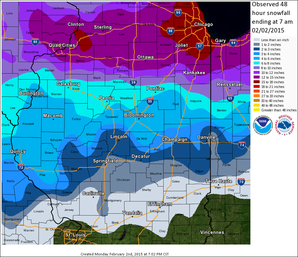
A major winter storm impacted the Midwest from Saturday, January 31st through Monday, February 2nd...bringing widespread heavy snow from Iowa eastward across north-central Illinois into the southern Great Lakes. Snowfall totals in excess of 6 inches occurred along and north of a Macomb...to Bloomington...to Lafayette, Indiana line. The heaviest snow fell along and north of I-80, with as much as 18 to 22 inches being observed in the Chicago area near Lake Michigan.
The storm system that caused the heavy snow developed as a result of two separate upper-level disturbances joining forces. One piece of energy ejected northeastward from a deep upper low over the Desert Southwest, while a second wave dropped southeastward out of Canada. As these two features merged, a surface low pressure system developed in the lee of the Rockies across eastern Colorado on Saturday, January 31st. The low shifted eastward to Kansas City by the morning of Sunday, February 1st, then deepened and tracked to near Terre Haute, Indiana by Sunday evening.
The first wave of precipitation associated with the approaching low pressure system arrived across central Illinois Saturday afternoon. With temperatures in the upper 30s and lower 40s at the time, the precipitation generally started out as light rain. As evaporative cooling took place within the atmospheric column, the rain mixed with sleet and snow by evening, particularly along and northeast of I-74. Additional precipitation spread into the area from Missouri by late evening, and as temperatures continued to slowly cool, the precipitation changed to mostly snow across the Illinois River Valley as well as along and north of I-74. Further south, little or no precipitation was falling across southeast Illinois. As the low tracked further eastward, precipitation spread across the remainder of central and southeast Illinois late Saturday night into Sunday morning. Wet snow fell north of the I-70 corridor, while rain was the primary precipitation type to the south.
The steady precipitation from Saturday night gradually shifted east of the region by Sunday afternoon, leaving behind scattered rain and snow showers. High temperatures on Sunday were above freezing, ranging from the lower 30s north of I-74 to the middle 40s south of I-70. Due to the warm temperatures, some of the snow that fell the night before melted and settled, making obtaining accurate snowfall measurements a bit difficult. As the surface low pressure tracked into west-central Indiana, strong northerly winds gusting to between 30 and 35mph developed by late Sunday afternoon and evening. In addition, light to moderate snow on the back side of the departing system spread back into much of central Illinois north of the I-70 corridor. The falling temperatures caused residual slush and water to freeze on the roadways, creating slick and hazardous driving conditions Sunday night. Light snow continued to accumulate through the evening before gradually tapering off to flurries and ending by the early morning of Monday, February 2nd.
Snowfall totals across central Illinois were lower than previously expected due to the prolonged period of rain Saturday evening and melting/settling of the extremely wet snow. When the storm concluded, totals ranged from 2 to 4 inches along the I-72 corridor from Jacksonville to Danville...to 6 to 8 inches along and north of a Macomb to Bloomington line.
Here is a snowfall map of the event.
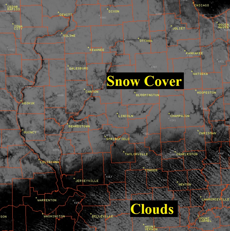
Here is a visible satellite image taken during the afternoon of Monday, February 2nd. Note the widespread snow cover across central and northern Illinois (white area with rivers evident), while locations south of I-70 are totally snow-free.