Overview
Multiple rounds of severe weather and heavy rainfall occurred across central and southeast Illinois from August 1-3, 2022.
On August 1, strong to severe storms spread in from the northwest early in the morning and continued through the late morning hours, bringing numerous damaging wind reports and an EF-1 tornado in Beason, IL. A lull in precipitation was seen from late morning through early afternoon before additional storms developed along a stalled frontal boundary later in the afternoon and continued through the evening hours. Severe storms that produced hail up to hen egg sized (2 inches), damaging winds, and extreme rainfall were observed south of Interstate 70. Moderate to occasionally heavy rainfall continued into the late night hours of August 1.
A nocturnal complex of strong to severe thunderstorms spread southeast from Iowa during the early morning hours of August 2 and brought multiple rounds of heavy rainfall. This contributed to flooding, especially where soils were already super saturated from previous rainfall. By the time rain ended later in the day on August 2, rainfall totals surpassed 5-7"+ in parts of southeast Illinois.
The final round of storms and heavy rainfall spread into central Illinois during the afternoon hours of August 3. Damaging winds and small hail were observed across parts of the state with additional rainfall amounts of 1-3"+ that fell roughly between the Interstate 55 and 70 corridors. This helped alleviated some of the drought ridden areas across east-central Illinois.
Despite the historic rainfall, fairly minimal societal impacts were reported. A couple of water rescues across Jasper County along with flooded underpasses in Decatur were a few of the more notable reports.
Tornadoes:
|
Beason Tornado
|
||||||||||||||||
|
Mason City Tornado
|
||||||||||||||||
The Enhanced Fujita (EF) Scale classifies tornadoes into the following categories:
| EF0 Weak 65-85 mph |
EF1 Moderate 86-110 mph |
EF2 Significant 111-135 mph |
EF3 Severe 136-165 mph |
EF4 Extreme 166-200 mph |
EF5 Catastrophic 200+ mph |
 |
|||||
Flooding
More info to follow.
Hydrographs
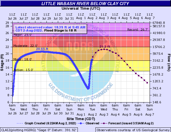 |
 |
||
| Rapid rises observed on the morning of Aug 2 along the Little Wabash River at Clay City from heavy rainfall | Rapid rises observed on the morning of Aug 2 along the Embarras River at Lawrenceville from heavy rainfall |
Radar/Warnings
 |
 |
||
| Flash Flood Warnings over southeast IL on the morning of Aug 2 | Radar estimated rainfall over southeast IL at 9 PM CDT Aug 1 (this is not observed rainfall & may be subject to errors) |
Meteorology
Write up to follow.
Photos
 |
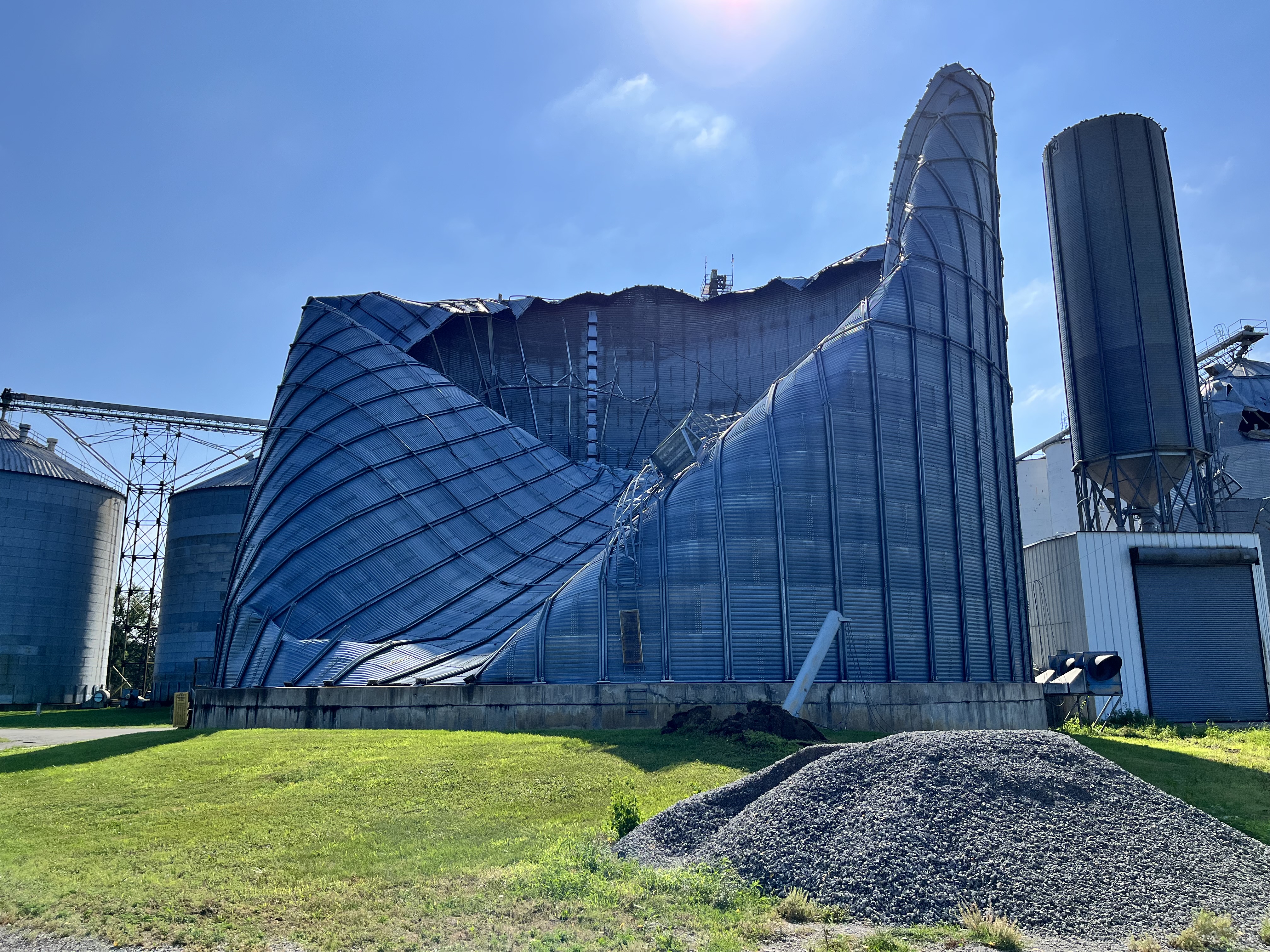 |
 |
 |
| Aug 1 - Beason Tornado Damage (Logan County EM) |
Aug 1 - Beason Tornado Damage (Logan County EM) |
Aug 1 - Beason Tornado Damage (Logan County EM) |
Aug 1 - Beason Tornado Damage (NWS Employee - Kirk Huettl) |
 |
 |
 |
|
| Aug 1 - Olney, IL Hail (Matthew Kocher) |
Aug 1 - Tolono, IL Storm Damage (Andrew Prtichard) |
Aug 2 - Shelf Cloud at NWS Lincoln (NWS Employee - Alex Erwin) |
Radar - Beason Tornado
|
Image 1
|
Image 2
|
|
5:10 AM CDT, 4.0 degree tilt Base Reflectivity (left) / Storm Relative Velocity (right) |
5:12 AM CDT, 0.5 degree tilt Base Reflectivity (left) / Storm Relative Velocity (right) |
|
Image 3
|
Image 4
|
|
5:13 AM CDT, 0.9 degree tilt Base Reflectivity (left) / Storm Relative Velocity (right) |
5:14 AM CDT, 1.4 degree tilt Base Reflectivity (left) / Storm Relative Velocity (right) |
The velocity data in Image 1 shows how strong the winds were at about 2,400 ft AGL, 89 kts (102 mph) just before the Beason Tornado developed. Some of this momentum mixed down to the surface as straight line winds. The Beason Tornado was embedded within the straight line winds. In Images 1-3, a small velocity couplet can be seen where green meets red. This is, in fact, the tornado.
Storm Reports
 |
 |
 |
 |
| Through 6:59 AM CDT Aug 1 | 7 AM CDT Aug 1 - 6:59 AM CDT Aug 2 | 7 AM CDT Aug 2 - 6:59 AM CDT Aug 3 | 7 AM CDT Aug 3 - 6:59 AM CDT Aug 4 |
PRELIMINARY LOCAL STORM REPORT...SUMMARY
NATIONAL WEATHER SERVICE LINCOLN IL
300 PM CDT THU AUG 4 2022

..TIME...   ...EVENT...      ...CITY LOCATION...     ...LAT.LON...
..DATE...   ....MAG....      ..COUNTY LOCATION..ST.. ...SOURCE....
            ..REMARKS..

0455 AM     TSTM WND DMG     HOPEDALE                40.43N 89.42W
08/01/2022                   TAZEWELL           IL   PUBLIC

            CORRECTS PREVIOUS TSTM WND DMG REPORT FROM
            HOPEDALE. DELAYED REPORT. DAMAGE TO TREE
            LIMBS AND POWER LINES. TIME ESTIMATED FROM
            RADAR.

0455 AM     TSTM WND DMG     3 SSE TREMONT           40.48N 89.47W
08/01/2022                   TAZEWELL           IL   PUBLIC

            SEVERAL TREE LIMBS BROKEN. TIME ESTIMATE VIA
            RADAR. REPORT RELAYED BY BROADCAST MEDIA.

0458 AM     TSTM WND GST     4 SE TREMONT            40.48N 89.44W
08/01/2022  M62 MPH          TAZEWELL           IL   EMERGENCY MNGR

            POWER WENT OUT AT THAT TIME.

0500 AM     TSTM WND DMG     1 ESE DILLON            40.47N 89.51W
08/01/2022                   TAZEWELL           IL   PUBLIC


0505 AM     TSTM WND DMG     4 WNW LINCOLN           40.17N 89.44W
08/01/2022                   LOGAN              IL   EMERGENCY MNGR

            LARGE TREES SNAPPED AT BASE. LARGEST TREE
            WAS 24 INCHES IN DIAMETER. A LARGE OUT
            BUILDING WAS ALSO DAMAGED. TIME ESTIMATED
            VIA RADAR.

0510 AM     TSTM WND DMG     BEASON                  40.14N 89.19W
08/01/2022                   LOGAN              IL   PUBLIC

            GRAIN BIN DAMAGED. TIME ESTIMATED VIA RADAR.

0512 AM     TORNADO          BEASON                  40.14N 89.19W
08/01/2022                   LOGAN              IL   NWS STORM SURVEY

            EF1 TORNADO ESTIMATED WITH 105 MPH WINDS
            DAMAGED LARGE GRAIN BINS ON FAR WEST END OF
            BEASON AND TOOK DOWN SOME LARGE TREES AND
            BRANCHES NEAR A FEW HOMES WITH SOME ROOF
            DAMAGE AND A WINDOW DAMAGED. TORNADO THEN
            TRAVELED NEAR 2 MILES SOUTHEAST OF BEASON
            OVER CORNFIELDS LIFTING AT 515 AM.

0532 AM     TSTM WND DMG     ARGENTA                 39.98N 88.82W
08/01/2022                   MACON              IL   PUBLIC

            THREE TREES WERE BLOWN DOWN AND A GAZEBO WAS
            TOSSED ONTO THE ROOF OF A HOUSE, CAUSING
            DAMAGE TO THE ROOF.

0540 AM     TSTM WND DMG     DECATUR                 39.84N 88.95W
08/01/2022                   MACON              IL   PUBLIC

            TREE BRANCHES DOWN. TIME ESTIMATED VIA
            RADAR.

0540 AM     TSTM WND DMG     3 ENE DECATUR           39.86N 88.91W
08/01/2022                   MACON              IL   PUBLIC

            SOCIAL MEDIA PHOTO RELAYED BY BROADCAST
            MEDIA SHOWS LARGE TREE BLOWN ONTO HOUSE,
            CAUSING STRUCTURAL DAMAGE. TIME ESTIMATED
            VIA RADAR.

0545 AM     TSTM WND DMG     CERRO GORDO             39.89N 88.73W
08/01/2022                   PIATT              IL   PUBLIC

            SOCIAL MEDIA PHOTO SHOWS TREE BRANCHES DOWN,
            ONE OF WHICH FELL ONTO A CHAIN LINK FENCE
            AND DAMAGED THE FENCE. TIME ESTIMATED BY
            RADAR.

0546 AM     TSTM WND GST     DECATUR AIRPORT         39.83N 88.86W
08/01/2022  M66 MPH          MACON              IL   ASOS


0547 AM     TSTM WND GST     WILLARD AIRPORT         40.04N 88.28W
08/01/2022  M56 MPH          CHAMPAIGN          IL   ASOS


0550 AM     TSTM WND DMG     BEMENT                  39.92N 88.57W
08/01/2022                   PIATT              IL   PUBLIC

            TREES DOWN. TIME ESTIMATED VIA RADAR.

0558 AM     TSTM WND DMG     2 NE TOLONO             40.00N 88.24W
08/01/2022                   CHAMPAIGN          IL   EMERGENCY MNGR

            EIGHT POWER POLES BLOWN DOWN. TIME ESTIMATED
            VIA RADAR.

0600 AM     TSTM WND DMG     GARRETT                 39.80N 88.43W
08/01/2022                   DOUGLAS            IL   PUBLIC

            DAMAGE TO ROOF OF SHED. ALSO REPORTED MINOR
            HOME EXTERIOR DAMAGE TO SIDING, GUTTERS.
            TIME ESTIMATED VIA RADAR.

0610 AM     TSTM WND DMG     LONGVIEW                39.89N 88.07W
08/01/2022                   CHAMPAIGN          IL   PUBLIC

            TREE DOWN AND CORN BLOWN OVER. TIME
            ESTIMATED VIA RADAR.

0615 AM     TSTM WND DMG     JAMAICA                 39.99N 87.81W
08/01/2022                   VERMILION          IL   PUBLIC

            TREES DOWN. TIME ESTIMATED BY RADAR.

0620 AM     TSTM WND DMG     SIDELL                  39.91N 87.82W
08/01/2022                   VERMILION          IL   PUBLIC

            TREES DOWN. TIME ESTIMATED VIA RADAR.

0625 AM     TSTM WND DMG     BROCTON                 39.72N 87.93W
08/01/2022                   EDGAR              IL   PUBLIC

            TREE BRANCHES DOWN. TIME ESTIMATED VIA
            RADAR.

0625 AM     TSTM WND DMG     HINDSBORO               39.68N 88.13W
08/01/2022                   DOUGLAS            IL   PUBLIC

            LARGE TREE UPROOTED SOUTH OF HINDSBORO. TIME
            ESTIMATED VIA RADAR.

0626 AM     TSTM WND DMG     INDIANOLA               39.93N 87.74W
08/01/2022                   VERMILION          IL   PUBLIC

            TREES AND POWERLINES DOWN. TIME ESTIMATED
            VIA RADAR.

0630 AM     TSTM WND DMG     RIDGE FARM              39.90N 87.65W
08/01/2022                   VERMILION          IL   PUBLIC

            8 TO 12 INCH DIAMETER BRANCHES DOWN. TIME
            ESTIMATED VIA RADAR.

0455 PM     TSTM WND DMG     1 ENE OLNEY             38.74N 88.08W
08/01/2022                   RICHLAND           IL   PUBLIC

            LARGE TREE BLOWN DOWN ON N EAST ST, A FEW
            YDS FROM CARLE RICHLAND MEMORIAL HOSPITAL.
            VIA SOCIAL MEDIA.

0650 PM     TSTM WND DMG     4 ENE BERRYVILLE        38.63N 87.86W
08/01/2022                   LAWRENCE           IL   FIRE DEPT/RESCUE

            THREE FOOT DIAMETER TREES SNAPPED AND
            UPROOTED.

0310 AM     TSTM WND DMG     MECHANICSBURG           39.81N 89.40W
08/02/2022                   SANGAMON           IL   MESONET

            DELAYED REPORT. LARGE TREE BRANCH (ESTIMATED
            24 INCH DIAMETER) DOWN, PHOTO PROVIDED. SWOP
            REPORT.

0725 AM     TSTM WND DMG     YATES CITY              40.78N 90.01W
08/02/2022                   KNOX               IL   BROADCAST MEDIA

            LARGE TREE LIMB BLOWN DOWN. RELAYED VIA
            WMBD-TV.

0805 AM     TSTM WND DMG     2 ESE TREMONT           40.52N 89.46W
08/02/2022                   TAZEWELL           IL   PUBLIC

            LARGE AREA OF CORN FLATTENED. TIME ESTIMATED
            BY RADAR.

0835 AM     TSTM WND DMG     1 SE MCLEAN             40.31N 89.16W
08/02/2022                   MCLEAN             IL   PUBLIC

            POWER LINES DOWNED FROM HIGH WINDS.

0835 AM     TSTM WND DMG     ATLANTA                 40.26N 89.23W
08/02/2022                   LOGAN              IL   EMERGENCY MNGR

            POWER LINES DOWNED FROM HIGH WINDS.

0835 AM     TSTM WND DMG     LINCOLN                 40.15N 89.36W
08/02/2022                   LOGAN              IL   EMERGENCY MNGR

            POWER LINES DOWNED FROM HIGH WINDS.

0905 AM     TSTM WND DMG     HARRISTOWN              39.85N 89.08W
08/02/2022                   MACON              IL   LAW ENFORCEMENT

            POWER LINES BLOWN DOWN.

0905 AM     TSTM WND DMG     DECATUR                 39.85N 88.95W
08/02/2022                   MACON              IL   LAW ENFORCEMENT

            POWER LINES DOWNED FROM HIGH WINDS.

0910 AM     TSTM WND DMG     3 SE FORSYTH            39.89N 88.91W
08/02/2022                   MACON              IL   PUBLIC

            LARGE TREE BROKEN ON EAST MOUND RD. NEAR
            HIGHWAY 48.

0920 AM     TSTM WND DMG     MACON                   39.71N 89.00W
08/02/2022                   MACON              IL   LAW ENFORCEMENT

            POWER LINES BLOWN DOWN.

0930 AM     TSTM WND DMG     BETHANY                 39.64N 88.74W
08/02/2022                   MOULTRIE           IL   EMERGENCY MNGR

            UPDATES PREVIOUS THUNDERSTORM WIND DAMAGE
            REPORT FROM BETHANY. MULTIPLE TREE LIMBS
            DOWN THROUGH TOWN. SEVERAL POWER POLES BLOWN
            DOWN AS WELL.

0955 AM     TSTM WND DMG     SULLIVAN                39.60N 88.61W
08/02/2022                   MOULTRIE           IL   PUBLIC

            CORRECTS PREVIOUS TSTM WND DMG REPORT FROM
            SULLIVAN. TREES UPROOTED AND LARGE BRANCHES
            SNAPPED. POWER LINES DOWNED.

1115 AM     TSTM WND DMG     FLORA                   38.67N 88.49W
08/02/2022                   CLAY               IL   EMERGENCY MNGR

            MULTIPLE TREES DOWN IN THE CITY. LIGHT POLE
            DOWN AT THE BASEBALL FIELD.

0359 PM     TSTM WND GST     DECATUR AIRPORT         39.83N 88.86W
08/03/2022  M61 MPH          MACON              IL   ASOS


0400 PM     TSTM WND DMG     2 ESE DECATUR           39.83N 88.92W
08/03/2022                   MACON              IL   NEWSPAPER

            TREE AND POWER LINE DOWN NEAR DECATUR
            AIRPORT. TIME ESTIMATED.

0405 PM     TSTM WND DMG     HOOPESTON               40.47N 87.67W
08/03/2022                   VERMILION          IL   EMERGENCY MNGR

            POWER LINE DOWN ON WEST MAIN ST. TIME
            ESTIMATED.

0440 PM     TSTM WND GST     3 SW BISMARCK           40.23N 87.65W
08/03/2022  M55 MPH          VERMILION          IL   EMERGENCY MNGR


0656 PM     TSTM WND DMG     EFFINGHAM               39.12N 88.54W
08/03/2022                   EFFINGHAM          IL   LAW ENFORCEMENT

            TREE LIMBS AND POWER LINES DOWN IN TOWN.
            TIME ESTIMATED.

0723 PM     TSTM WND DMG     1 WSW LOUISVILLE        38.77N 88.53W
08/03/2022                   CLAY               IL   EMERGENCY MNGR

            TREE KNOCKED DOWN A COUPLE POLES WEST OF
            LOUISVILLE ON KINMUNDY RD. TIME ESTIMATED.


&&

$$
Rain Reports
 |
| 4-day Rainfall Total (10 AM July 31 - 10 AM Aug 4) |
Public Information Statement
National Weather Service Lincoln IL
101 PM CDT Thu Aug 4 2022

...FOUR DAY PRECIPITATION TOTALS...

Precipitation totals from the morning of Sunday, July 31st, through the
morning of Thursday, August 4th.

Location                     Amount    Time/Date       Lat/Lon

...Illinois...

...Cass County...
3 SSE Bluff Springs          0.12 in   0800 AM 08/04   39.95N/90.33W

...Champaign County...
Lake of the Woods            3.02 in   0800 AM 08/04   40.20N/88.37W
1 SSW Lake of the Woods      2.84 in   0800 AM 08/04   40.20N/88.37W
1 N Savoy                    2.79 in   0800 AM 08/04   40.09N/88.25W
4 NNE Lake of the Woods      2.55 in   0800 AM 08/04   40.26N/88.34W
1 S Champaign                2.49 in   0800 AM 08/04   40.10N/88.26W
3 WNW Savoy                  2.47 in   0800 AM 08/04   40.08N/88.30W
1 SW Champaign               2.45 in   0800 AM 08/04   40.11N/88.28W
Champaign                    2.43 in   0800 AM 08/04   40.11N/88.26W
1 NNE Savoy                  2.43 in   0800 AM 08/04   40.08N/88.24W
1 N Lake of the Woods        2.34 in   0800 AM 08/04   40.23N/88.36W
Champaign                    2.31 in   0800 AM 08/04   40.12N/88.26W
1 NW Savoy                   2.29 in   0800 AM 08/04   40.08N/88.27W
2 WNW Savoy                  2.23 in   0800 AM 08/04   40.08N/88.29W
1 NNE Champaign              2.20 in   0800 AM 08/04   40.12N/88.26W
Champaign                    2.17 in   0800 AM 08/04   40.12N/88.27W
Urbana                       2.17 in   0800 AM 08/04   40.11N/88.20W
1 SSE Urbana                 2.15 in   0800 AM 08/04   40.10N/88.20W
Sadorus                      2.12 in   0800 AM 08/04   39.97N/88.35W
2 N Homer                    2.01 in   0800 AM 08/04   40.06N/87.96W
Ogden                        2.00 in   0800 AM 08/04   40.11N/87.96W
1 ENE Saint Joseph           1.98 in   0800 AM 08/04   40.12N/88.02W
1 NW Mahomet                 1.93 in   0800 AM 08/04   40.20N/88.42W
Willard Airport              1.92 in   0800 AM 08/04   40.04N/88.28W
1 N Sidney                   1.92 in   0800 AM 08/04   40.04N/88.07W
1 S Mahomet                  1.85 in   0800 AM 08/04   40.18N/88.40W
2 NW Homer                   1.82 in   0800 AM 08/04   40.05N/87.98W
Homer                        1.80 in   0800 AM 08/04   40.04N/87.96W
1 W Urbana                   1.78 in   0800 AM 08/04   40.11N/88.22W
1 WNW Lake of the Woods      1.77 in   0800 AM 08/04   40.22N/88.39W
1 WNW Willard Airport        1.73 in   0800 AM 08/04   40.04N/88.29W
2 NNE Homer                  1.72 in   0800 AM 08/04   40.06N/87.95W
1 SSE Savoy                  1.68 in   0800 AM 08/04   40.06N/88.25W
3 ENE Bondville              1.62 in   0800 AM 08/04   40.13N/88.32W
2 ENE Urbana                 1.52 in   0800 AM 08/04   40.12N/88.17W
2 SE Urbana                  1.52 in   0800 AM 08/04   40.09N/88.17W
3 ENE Urbana                 1.39 in   0800 AM 08/04   40.12N/88.16W
1 NNE Rantoul                1.36 in   0800 AM 08/04   40.32N/88.15W
1 N Fisher                   0.91 in   0800 AM 08/04   40.33N/88.35W
4 N Fisher                   0.86 in   0800 AM 08/04   40.38N/88.34W

...Christian County...
3 W Edinburg                 3.19 in   0800 AM 08/04   39.65N/89.45W
1 SSW Pana                   3.02 in   0800 AM 08/04   39.37N/89.09W
Morrisonville                2.80 in   0800 AM 08/04   39.42N/89.46W
1 SSE Morrisonville          2.64 in   0800 AM 08/04   39.41N/89.45W
3 S Assumption               2.61 in   0800 AM 08/04   39.47N/89.05W
3 SE Taylorville             2.21 in   0800 AM 08/04   39.52N/89.26W
Pana                         2.08 in   0800 AM 08/04   39.39N/89.09W
Taylorville Airport          2.02 in   0800 AM 08/04   39.53N/89.33W

...Clark County...
1 E Casey                    1.59 in   0800 AM 08/04   39.30N/87.97W
Marshall                     0.78 in   0800 AM 08/04   39.39N/87.69W
1 SSW Marshall               0.74 in   0800 AM 08/04   39.38N/87.70W

...Clay County...
6 SSE Clay City              6.74 in   0800 AM 08/04   38.61N/88.31W
1 NNE Flora                  4.47 in   0800 AM 08/04   38.68N/88.48W
1 SE Flora                   4.23 in   0800 AM 08/04   38.66N/88.48W

...Coles County...
Coles County Airport         2.49 in   0800 AM 08/04   39.48N/88.28W
4 NE Janesville              2.41 in   0800 AM 08/04   39.42N/88.19W
Mattoon                      2.41 in   0800 AM 08/04   39.48N/88.38W
1 ESE Mattoon                2.40 in   0800 AM 08/04   39.48N/88.36W

...Crawford County...
Robinson                     1.05 in   0800 AM 08/04   39.00N/87.74W
Hutsonville                  0.93 in   0800 AM 08/04   39.11N/87.66W
1 E Robinson                 0.74 in   0800 AM 08/04   39.01N/87.73W

...Cumberland County...
1 WSW Neoga                  4.81 in   0800 AM 08/04   39.32N/88.46W

...De Witt County...
3 WSW Farmer City            1.91 in   0800 AM 08/04   40.23N/88.69W
1 SSW Clinton                1.14 in   0800 AM 08/04   40.14N/88.97W
1 SW Clinton                 1.05 in   0800 AM 08/04   40.15N/88.97W

...Douglas County...
1 WSW Tuscola                1.52 in   0800 AM 08/04   39.79N/88.29W
1 NNE Tuscola                1.51 in   0800 AM 08/04   39.81N/88.28W
Newman                       1.41 in   0800 AM 08/04   39.80N/87.98W

...Edgar County...
1 E Paris                    1.12 in   0800 AM 08/04   39.62N/87.67W
4 SSE Kansas                 0.85 in   0800 AM 08/04   39.50N/87.91W

...Effingham County...
3 SE Teutopolis              7.14 in   0800 AM 08/04   39.10N/88.43W
3 WNW Effingham              6.60 in   0800 AM 08/04   39.13N/88.59W
1 SSE Effingham              5.41 in   0800 AM 08/04   39.11N/88.53W
Watson                       5.05 in   0800 AM 08/04   39.03N/88.57W
Watson                       5.05 in   0800 AM 08/04   39.03N/88.57W
4 SSW Altamont               4.81 in   0800 AM 08/04   39.00N/88.77W
Effingham County Airport     4.43 in   0800 AM 08/04   39.07N/88.53W

...Fulton County...
1 E Canton                   2.44 in   0800 AM 08/04   40.56N/90.02W
Bryant                       2.35 in   0800 AM 08/04   40.47N/90.10W
1 ENE Canton                 2.26 in   0800 AM 08/04   40.56N/90.02W
1 SSW Canton                 2.22 in   0800 AM 08/04   40.54N/90.04W
Avon                         1.02 in   0800 AM 08/04   40.66N/90.44W
Avon                         1.01 in   0800 AM 08/04   40.66N/90.44W

...Jasper County...
1 W Newton                   7.09 in   0800 AM 08/04   38.99N/88.18W
3 SE Rose Hill               5.29 in   0800 AM 08/04   39.07N/88.11W
Yale                         3.36 in   0800 AM 08/04   39.12N/88.03W

...Knox County...
Yates City                   1.68 in   0800 AM 08/04   40.78N/90.01W
Galesburg Airport            1.62 in   0800 AM 08/04   40.94N/90.43W
Altona                       1.45 in   0800 AM 08/04   41.12N/90.16W
1 SSE Altona                 1.44 in   0800 AM 08/04   41.10N/90.16W
1 W Galesburg                1.37 in   0800 AM 08/04   40.95N/90.39W
Knoxville                    1.14 in   0800 AM 08/04   40.91N/90.28W
1 NW Knoxville               1.03 in   0800 AM 08/04   40.91N/90.29W

...Logan County...
2 W Chestnut                 4.99 in   0800 AM 08/04   40.05N/89.22W
2 SW Latham                  4.86 in   0800 AM 08/04   39.95N/89.19W
1 SE Lawndale                4.45 in   0800 AM 08/04   40.21N/89.27W
1 ENE Elkhart                4.28 in   0800 AM 08/04   40.02N/89.47W
4 SW Beason                  3.97 in   0800 AM 08/04   40.10N/89.24W
Lincoln                      3.24 in   0800 AM 08/04   40.15N/89.37W
1 NNE Logan County Airport   3.23 in   0800 AM 08/04   40.17N/89.33W
Mount Pulaski                3.23 in   0800 AM 08/04   40.01N/89.28W
2 E Lincoln                  3.22 in   0800 AM 08/04   40.15N/89.34W
3 E Hartsburg                2.12 in   0800 AM 08/04   40.25N/89.38W
New Holland                  1.85 in   0800 AM 08/04   40.18N/89.58W

...Macon County...
2 SE Latham                  6.80 in   0800 AM 08/04   39.95N/89.14W
Decatur Airport              6.31 in   0800 AM 08/04   39.83N/88.87W
1 S Decatur                  4.98 in   0800 AM 08/04   39.83N/88.95W
2 SW Decatur                 4.85 in   0800 AM 08/04   39.82N/88.98W
1 E Warrensburg              4.59 in   0800 AM 08/04   39.93N/89.04W
4 NNE Illiopolis             3.74 in   0800 AM 08/04   39.91N/89.21W
1 S Oreana                   3.16 in   0800 AM 08/04   39.92N/88.87W

...Marshall County...
3 NNW Sparland               0.15 in   0800 AM 08/04   41.08N/89.47W
2 WSW Henry                  0.05 in   0800 AM 08/04   41.10N/89.38W

...McLean County...
5 SSW Le Roy                 2.20 in   0800 AM 08/04   40.29N/88.80W
1 E Heyworth                 1.73 in   0800 AM 08/04   40.31N/88.97W
1 SSW Bloomington            1.51 in   0800 AM 08/04   40.47N/89.00W
3 SW Bloomington             1.46 in   0800 AM 08/04   40.45N/89.03W
2 SW Le Roy                  1.35 in   0800 AM 08/04   40.33N/88.79W
Le Roy                       1.29 in   0800 AM 08/04   40.34N/88.77W
Downs                        1.20 in   0800 AM 08/04   40.40N/88.87W
2 WSW Central Illinois Airpo 1.14 in   0800 AM 08/04   40.47N/88.95W
2 S Central Illinois Airport 1.09 in   0800 AM 08/04   40.45N/88.91W
1 NNW Bloomington            1.06 in   0800 AM 08/04   40.50N/89.00W
3 NNW Downs                  1.01 in   0800 AM 08/04   40.43N/88.89W
Normal                       0.91 in   0800 AM 08/04   40.50N/88.99W
2 NNW Central Illinois Airpo 0.83 in   0800 AM 08/04   40.50N/88.93W
Central Illinois Airport     0.78 in   0800 AM 08/04   40.48N/88.92W
3 NE Bellflower              0.73 in   0800 AM 08/04   40.37N/88.49W
3 WSW Towanda                0.67 in   0800 AM 08/04   40.55N/88.95W
2 NNE Arrowsmith             0.64 in   0800 AM 08/04   40.47N/88.62W
3 WSW Towanda                0.56 in   0800 AM 08/04   40.55N/88.95W
Chenoa                       0.43 in   0800 AM 08/04   40.74N/88.72W

...Menard County...
3 NNE Ashland                1.65 in   0800 AM 08/04   39.92N/89.99W
3 N Salisbury                1.55 in   0800 AM 08/04   39.93N/89.80W

...Morgan County...
Murrayville                  1.85 in   0800 AM 08/04   39.59N/90.25W
2 E South Jacksonville       0.29 in   0800 AM 08/04   39.71N/90.19W
1 WNW South Jacksonville     0.19 in   0800 AM 08/04   39.72N/90.25W
1 N Jacksonville             0.17 in   0800 AM 08/04   39.75N/90.23W

...Moultrie County...
4 WSW Hammond                3.58 in   0800 AM 08/04   39.77N/88.65W
Lovington                    2.52 in   0800 AM 08/04   39.71N/88.63W
1 N Arthur                   2.13 in   0800 AM 08/04   39.73N/88.47W
1 WSW Arthur                 1.81 in   0800 AM 08/04   39.71N/88.49W
3 SW Atwood                  1.80 in   0800 AM 08/04   39.77N/88.50W

...Peoria County...
3 WNW Peoria Heights         3.62 in   0800 AM 08/04   40.75N/89.62W
3 W Alta                     3.00 in   0800 AM 08/04   40.82N/89.68W
Peoria Intl Airport          1.69 in   0800 AM 08/04   40.67N/89.69W
1 NE Trivoli                 1.34 in   0800 AM 08/04   40.70N/89.88W
2 ESE Duncan                 1.28 in   0800 AM 08/04   40.97N/89.76W
3 NE Dunlap                  1.13 in   0800 AM 08/04   40.89N/89.64W

...Piatt County...
4 N Cerro Gordo              3.55 in   0800 AM 08/04   39.95N/88.72W
3 NE Milmine                 3.52 in   0800 AM 08/04   39.94N/88.62W
3 SE Cisco                   2.83 in   0800 AM 08/04   39.99N/88.69W
5 NE Hammond                 2.81 in   0800 AM 08/04   39.85N/88.54W
Cisco                        1.95 in   0800 AM 08/04   40.01N/88.73W
3 SE Mansfield               1.52 in   0800 AM 08/04   40.17N/88.47W
3 WSW Mansfield              1.52 in   0800 AM 08/04   40.19N/88.56W
1 ENE Monticello             1.35 in   0800 AM 08/04   40.03N/88.56W
4 NW Seymour                 1.30 in   0800 AM 08/04   40.14N/88.48W
3 NE Mansfield               1.00 in   0800 AM 08/04   40.24N/88.46W

...Richland County...
2 E Dundas                   7.07 in   0800 AM 08/04   38.83N/88.06W
2 NE Olney                   4.85 in   0800 AM 08/04   38.75N/88.07W
2 S Olney                    4.27 in   0800 AM 08/04   38.70N/88.08W

...Sangamon County...
1 NW Buffalo                 4.07 in   0800 AM 08/04   39.86N/89.42W
2 W Leland Grove             2.95 in   0800 AM 08/04   39.77N/89.72W
3 W Leland Grove             2.73 in   0800 AM 08/04   39.78N/89.73W
2 E Chatham                  2.34 in   0800 AM 08/04   39.67N/89.67W
2 ESE Chatham                2.32 in   0800 AM 08/04   39.67N/89.67W
2 SSW Capital Airport        2.00 in   0800 AM 08/04   39.81N/89.69W
Capital Airport              1.95 in   0800 AM 08/04   39.84N/89.68W
1 WSW Sherman                1.77 in   0800 AM 08/04   39.89N/89.62W
2 E Southern View            1.29 in   0800 AM 08/04   39.76N/89.61W
2 E Southern View            1.01 in   0800 AM 08/04   39.76N/89.60W

...Shelby County...
1 ENE Shelbyville            6.48 in   0800 AM 08/04   39.41N/88.80W
2 E Shelbyville              6.36 in   0800 AM 08/04   39.41N/88.77W
3 S Moweaqua                 5.29 in   0800 AM 08/04   39.59N/89.02W
4 WNW Mode                   4.00 in   0800 AM 08/04   39.28N/88.80W
1 N Windsor                  3.05 in   0800 AM 08/04   39.45N/88.60W

...Stark County...
Toulon                       1.09 in   0800 AM 08/04   41.09N/89.87W
Bradford                     0.20 in   0800 AM 08/04   41.18N/89.66W

...Tazewell County...
1 NNW Washington             3.89 in   0800 AM 08/04   40.72N/89.41W
4 W Tremont                  3.66 in   0800 AM 08/04   40.53N/89.56W
1 SSW Morton                 3.08 in   0800 AM 08/04   40.60N/89.47W
1 SSW Morton                 3.01 in   0800 AM 08/04   40.60N/89.47W
2 NNW Washington             2.91 in   0800 AM 08/04   40.73N/89.42W
4 ENE South Pekin            2.62 in   0800 AM 08/04   40.52N/89.60W
3 SSW Kingston Mines         1.93 in   0800 AM 08/04   40.51N/89.79W

...Vermilion County...
Vermilion Regional Airport   2.80 in   0800 AM 08/04   40.20N/87.60W
3 SSE Henning                2.69 in   0800 AM 08/04   40.27N/87.68W
1 E Hoopeston                2.15 in   0800 AM 08/04   40.46N/87.66W
3 W Bismarck                 2.08 in   0800 AM 08/04   40.26N/87.67W
2 ENE Royal                  1.79 in   0800 AM 08/04   40.20N/87.94W
3 NNW Danville               1.75 in   0800 AM 08/04   40.18N/87.65W
2 SSW Jamaica                1.71 in   0800 AM 08/04   39.97N/87.82W
4 W Vermilion Regional Airpo 1.52 in   0800 AM 08/04   40.19N/87.67W
1 NNW Fithian                1.51 in   0800 AM 08/04   40.13N/87.88W
1 NNW Georgetown             1.51 in   0800 AM 08/04   39.98N/87.64W
1 NNE Danville               1.22 in   0800 AM 08/04   40.15N/87.63W
3 E Danville                 1.18 in   0800 AM 08/04   40.14N/87.57W

...Woodford County...
1 SSW Germantown Hills       2.46 in   0800 AM 08/04   40.76N/89.48W
2 NNW Germantown Hills       2.32 in   0800 AM 08/04   40.79N/89.48W
1 WNW Metamora               1.16 in   0800 AM 08/04   40.80N/89.38W
1 W Congerville              0.77 in   0800 AM 08/04   40.61N/89.22W
1 N Minonk                   0.28 in   0800 AM 08/04   40.91N/89.03W
Roanoke                      0.14 in   0800 AM 08/04   40.80N/89.19W

Observations are collected from a variety of sources with varying
equipment and exposures. We thank all volunteer weather observers
for their dedication. Not all data listed are considered official.

$$
 |
Media use of NWS Web News Stories is encouraged! Please acknowledge the NWS as the source of any news information accessed from this site. |
|


