National Weather Service United States Department of Commerce


Cass County tornadoes since 1950


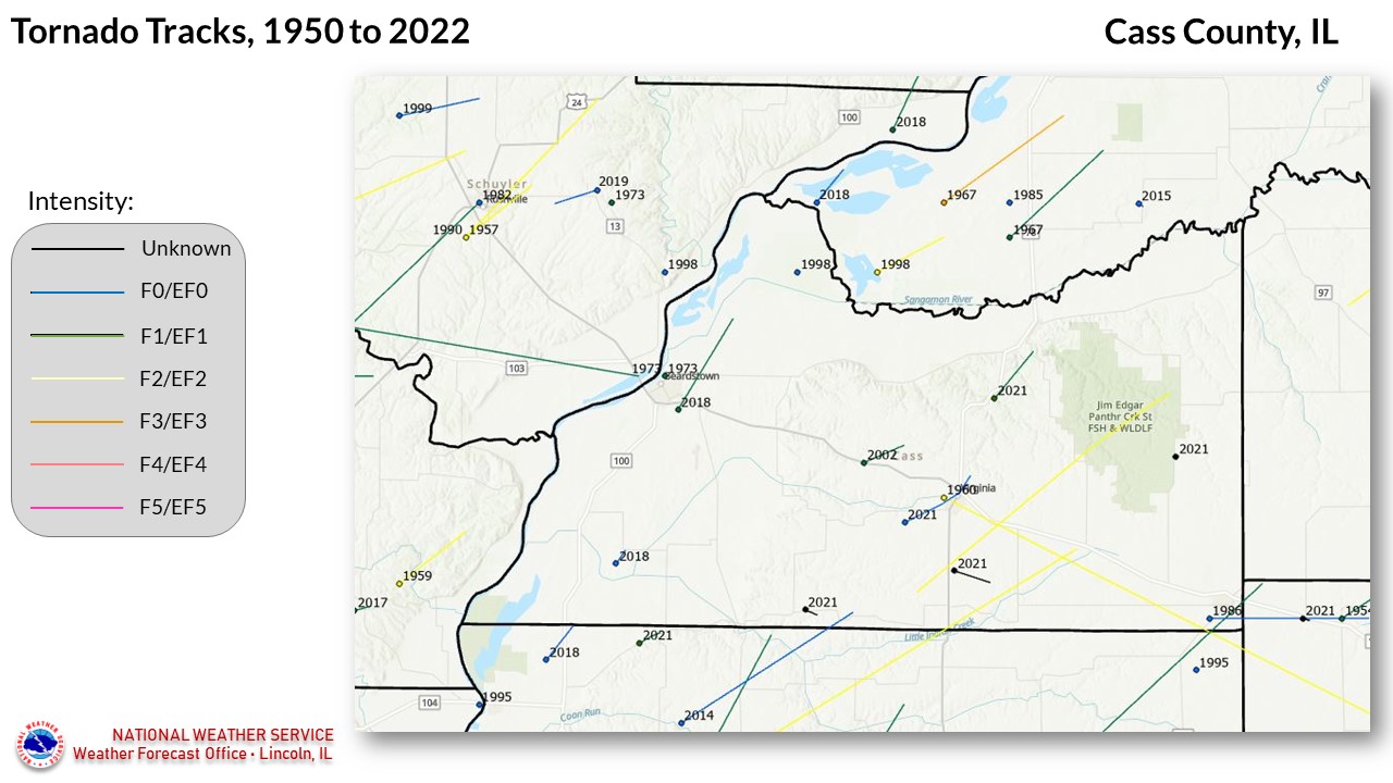
16 TORNADOES were reported in Cass County, Illinois between 01/01/1950 and 12/31/2022.

Click on Location or County to display Details.

Mag:
Dth:
Inj:
PrD:
CrD:
Magnitude
Deaths
Injuries
Property Damage
Crop Damage
Illinois
Location or County Date Time (CST) Mag Dth Inj PrD CrD
Virginia 06/23/1960 02:30 AM F2 0 1 250K 0
Beardstown 07/27/1973 07:00 PM F2 0 0 25K 0
Beardstown 08/08/1973 06:30 PM F1 0 0 0K 0
Ashland 06/04/1986 03:20 PM F0 0 0 0K 0
Beardstown 04/07/1998 03:10 PM F0 0 0 0 0
Ashland 04/08/1999 07:50 PM F1 1 6 1.8M 0
Bluff Springs 04/19/2002 06:27 PM F1 0 0 0 0
Arenzville 02/20/2014 02:59 PM EF0 0 0 0 0
9 Arenzville 12/01/2018 03:09 PM EF0 0 0 35K 0
10 Beardstown 12/01/2018 03:25 PM EF1 0 0 200K 0
11 Arenzville 05/03/2021 03:57 PM EFU 0 0 0 0
12 Virginia 05/03/2021 04:05 PM EFU 0 0 0 0
13 Virginia 07/10/2021 01:22 PM EF0 0 0 N/A 0
14 Chandlerville 07/10/2021 01:44 PM EF1 0 0 N/A N/A
15 Newmansville 07/10/2021 02:16 PM EFU 0 0 0 0
16 Virginia 12/10/2021 07:47 PM EF2 0 0 N/A 0
TOTALS: 1 7 2.26M 0


Details:

  1. 6/23/1960:   Approximate track from Virginia to Ashland.  12 miles long, 100 yards wide.
  2. 7/27/1973:   Located near Beardstown; brief touchdown.
  3. 8/8/1973:   Located near Beardstown; brief touchdown.
  4. 6/4/1986:   Approximate track from Ashland to Pleasant Plains (Sangamon County).  3 miles long, 100 yards wide.
  5. 4/7/1998:   7 miles northeast of Beardstown; brief touchdown, 50 yards wide.  From Storm Data:  A tornado touched down near Clear Lake. It caused minor damage to 5 cabins and tore part of the roof off of another one. Also, numerous trees were blown down. No injuries were reported and no damage estimate was available.
  6. 4/8/1999:   Track 1/2 mile northeast of Sinclair (Morgan County) to 1 mile northeast of Ashland.  Path length in Cass County 2 miles, width 300 yards.  From Storm Data: The tornado first touched down half a mile northeast of Sinclair (Morgan County). As it travelled to the northeast, it flipped over a mobile home and destroyed a barn near Yatesville. Nearby two outbuildings and a hog shelter were destroyed. As it approached Prentice, the tornado destroyed a small shed and carried parts of the shed over a nearby house then across the road to a field beyond, about 300 yards away. Windows on the house were blown out. As it continued to the northeast scouring marks could be seen in a field 1 mile southwest of Ashland (Cass County). The tornado entered Ashland on the southwest side of town around 851 PM CDT. It hit a trailer park, destroying 17 trailers and damaging 20. One woman was trapped under her mobile home for several hours. However, she died before they could pull her out. Six other people sustained injuries. As it travelled northeast through town, it destroyed one home, as well as, a city garage, and severely damaged 16 homes, a church, laundromat, and several brick buildings downtown. As it exited town it hit a grain elevator. However, the elevator appears to have broken up the tornado's circulation and no damage was reported to the elevator. North of Highway 125, it appears that the circulation became organized again, but much weaker. Plenty of debris from town was found in the field north of the highway. During a helicopter survey, scouring was evident in the field with the scouring marks splitting into two separate circulations, one going north northeast and the other more east northeast. After a short distance, about half a mile, both of the circulations dissipated. Damage in Ashland was estimated around $1,750,000.
  7. 4/19/2002:   Track 3.5 miles southeast of Bluff Springs to 3 miles northwest of Virginia.  Path length 2 miles, width 40 yards.  From Storm Data: A tornado briefly touched down 3.5 miles east southeast of Bluff Springs near Illinois Route 125. It was on the ground for about 2 miles, moving east northeast. Thirty to forty large trees were either broken off or uprooted. Also, a grain bin and three barns were destroyed. An ATV was picked up and thrown a short distance into a pickup truck. A number of power poles were snapped off. The tornado lifted about 2.5 miles northwest of Virginia.
  8. 2/20/2014:  Moved in from Morgan County, and lifted 2.3 miles east of Arenzville. It did not strike any structures along its path.
  9. 12/1/2018:  This tornado, part of a historic outbreak in central Illinois, affected areas northwest of Arenzville. Click here for more details. 
  10. 12/1/2018:  This tornado moved across the southeast portion of Beardstown and caused damage to the water treatment plant as well as several windows in vehicles. Click here for more details. 
  11. 5/3/2021:  Touched down in a field east-northeast of Arenzville and was on the ground for 2 minutes, causing no damage.
  12. 5/3/2021:  Touched down in a field 3 miles south of Virginia, moving southeast. No damage occurred.
  13. 7/10/2021:  Touched down west-southwest of Virginia, and damaged a bus barn for Virginia High School. Several trees were also damaged, before the tornado lifted about a mile northeast of Virginia. 
  14. 7/10/2021:  This tornado touched down southwest of Chandlerville and caused heavy tree and agricultural damage. A barn was also destroyed. 
  15. 7/10/2021:  Brief touchdown near the intersection of Newmansville Rd. and Cox Creek Rd, northeast of Philadelphia. 
  16. 12/10/2021:  Park of an outbreak of 5 EF-2 strength tornadoes in central Illinois. Click here for more details.