A lot is made of numerical weather prediction today. With the dawning of Internet, and more recently the rise in social media, our forecast models have become more visible to the general public. This is a good thing, but...
What most people don't realize is that we have access to an overwhelming amount of model data. We use over 30 different model systems that offer over 150 model solutions, and we combine all of this information into a single forecast.

Having access to all of this model data is both a blessing and a curse, but it allows for us to see the entire spectrum of possible forecast solutions. And rather than focus on 1 model solution, we link together similar solutions to form a more probabilistic forecast.
Global deterministic models such as the GFS (American), ECMWF (European), CMC (Canadian), and UKMET have become household names over the past decade, with short-term higher resolution models such as the HRRR and NAMNST also becoming very popular. Have you heard of these?
If you answered 'YES', you get a gold star. But are you familiar with the GEFS (American ensemble), EPS (European ensemble) and CMCE (Canadian ensemble), which collectively make up the Grand Ensemble, a nearly 100-member forecast solution? The fundamental difference between the GFS and GEFS is that the GFS is made of 1 deterministic solution while the GEFS is made of 30 ensemble solutions. Likewise, the ECMWF is 1 solution while the EPS is 50 solutions, and the CMC is 1 solution while the CMCE is 20 solutions.
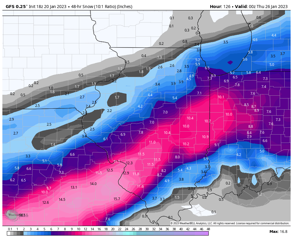
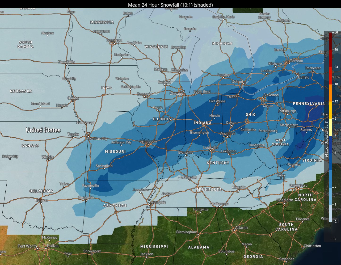
Now, let's compare how this looks on a map. The first image is a snowfall forecast from the GFS (1 solution). The second image is of the Grand Ensemble mean (100 solutions) for the same period. Which is the better forecast?
 |
 |
| GFS example snowfall forecast (from the midday model run on January 20, 2023) |
Ensemble forecast from the same period as the GFS example |
In recent years, the NWS has taken more of a blended or ensemble approach to forecasting. We believe this to be the superior method. Rather than message 1 solution (GFS), we prefer to leverage a multi-model and ensemble technique (NBM, Grand Ensemble).
One thing the Grand Ensemble lets us do is determine where within the entire forecast spectrum the GFS (1 solution) lies. In this case, the snowfall amounts from the GFS lie within the 95th percentile of the Grand Ensemble. In other words, the GFS is likely way overdone.
|
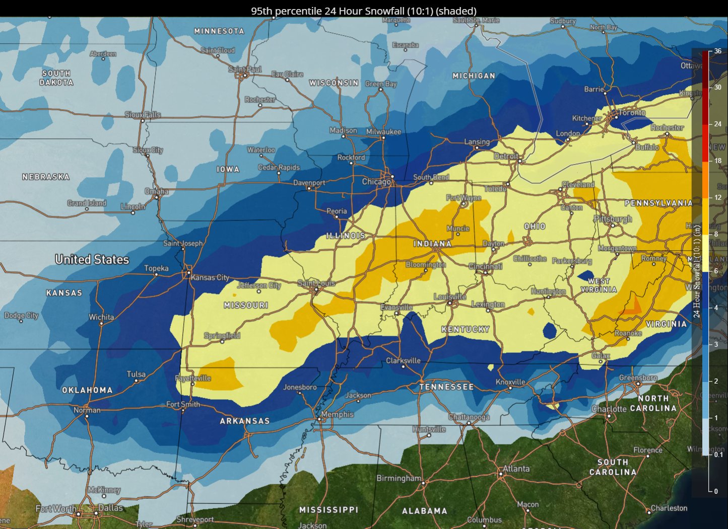 |
| GFS example snowfall forecast (from the midday model run on January 20, 2023) |
Ensemble 95th percentile forecast, which is basically a "worst case" scenario |
Often times, NWS is slower and more methodical in publishing our official snowfall forecast. We routinely get beaten to the punch by social media accounts or other news outlets, many of which will post a single model solution (e.g. GFS, ECMWF). All of this to say, be careful where you receive your forecast information. In social science and journalism, there's something called 'anchoring,' which is when someone becomes attached to the first forecast they see.