November Precipitation Highlights:
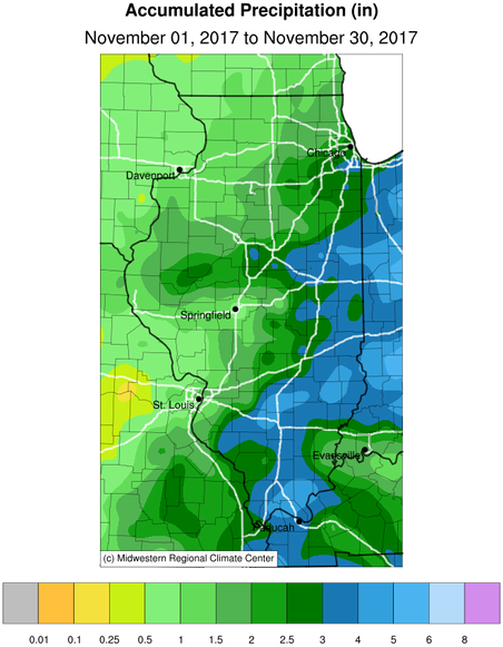
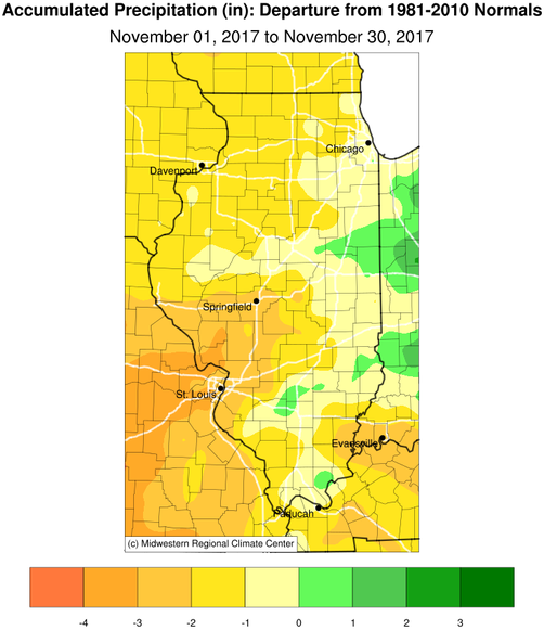
- Rainfall was below normal in November for much of central and western Illinois, while running near or a bit above normal in eastern Illinois. Totals were 1 to 2.5 inches below normal for many areas west of I-57 with the driest areas from Springfield southwest to the St Louis metro area. The exception was areas near Bloomington/Normal, where thunderstorms with heavy rains on morning of Nov 18th brought monthly totals to only about a half inch below normal. Moderate to severe drought conditions lingered over southwest IL near the Mississippi river valley. The latest U.S. Drought Monitor showed abnormally dry conditions for parts of central IL from Springfield to Effingham southwest.
November Temperature Highlights:
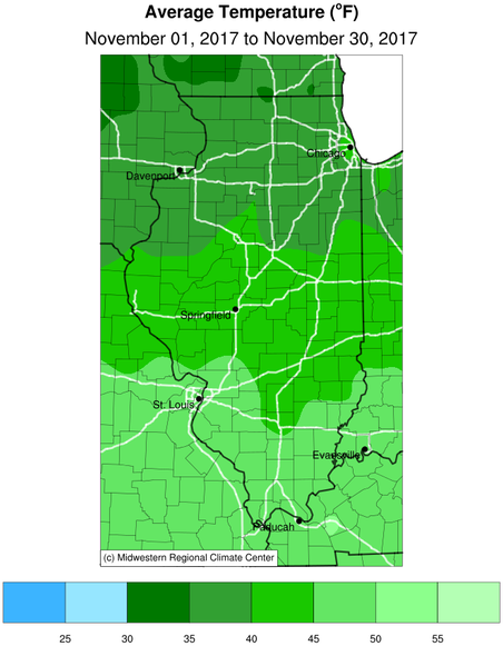
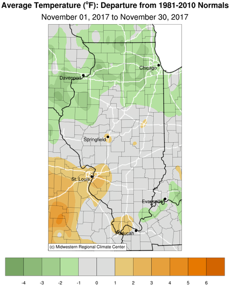
- Average November temperatures were in the lower 40s and were close to normal for a large part of central and southeast Illinois, except 1-2 degrees below normal over Knox and Fulton counties. Record highs in the mid to upper 60s were set over parts of central IL on Friday Nov 24th and again on Monday Nov 28th. The coldest temperatures during the month in the upper teens and lower 20s were set on the mornings of Nov 10th and 22nd.
November Weather Event Highlights:
- A slow moving cold front triggered severe weather across east central and southeast IL on Sunday afternoon and early evening hours of Nov 5th. Most of the activity developed along and southeast of a Champaign to Taylorville line, with the strongest storms producing wind gusts around 60 mph and hail up to nickel size. There was an EF1 tornado packing 105 mph winds in northern Richland county northwest of Olney around supper time that day damaging a few structures along its path. Storms further southwest along the front dropped very large hail up to baseball size near Collinsville, while several tornadoes were reported in eastern Indiana and northern Ohio. Overnight Friday night into Saturday morning of Nov 18th, a persistent band of showers and thunderstorms set up north of I-72 producing 1-3 inches of rain with localized flooding in part due to leaves clogging street gutters especially in urban areas. A brief period of moderate to heavy wet snow with 30-40 mph north winds brought around a half inch of wet snow to the Bloomington/Normal area early Saturday afternoon Nov 18th.
November 2017 Precipitation and Temperature Maps:
Climatological Statistics for November 2017 and Fall 2017 Season:
The following links are the monthly and seasonal climate summaries for area cities. Only the summaries for Peoria, Springfield, and Lincoln are considered "official", meaning they are the station of record for their respective locations. The other summaries are "supplemental", meaning another location in the area is the official climate station for the city.
- Peoria: (November) (Fall) -- Peoria International Airport
- Springfield: (November) (Fall) -- Abraham Lincoln Capital Airport
- Lincoln: (November) (Fall) -- NWS Office
- Champaign: (November) (Fall) -- University of Illinois-Willard Airport
- Decatur: (November) (Fall) -- Decatur Airport
- Lawrenceville: (November) (Fall) -- Lawrenceville-Vincennes International Airport
- Mattoon: (November) (Fall)-- Coles County Memorial Airport
Climate data for other cities is available at http://w2.weather.gov/climate/xmacis.php?wfo=ilx
----------------------------------------------------------------------------------------------------------------------------------------------------------------------------
Fall 2017 Season (September through November) Key Points:
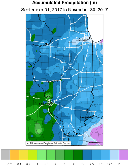
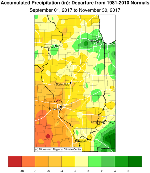
- The fall season saw below normal precipitation over central and western IL, with 1.5 to 3.5 inches below normal. Eastern IL was closer to normal for fall precipitation. September was a very dry month with Springfield only getting 0.01 inches of rain, making it their 2nd driest September. Peoria with 0.54 inches of rain and Lincoln with 0.71 inches of rain had their 3rd and 4th driest September respectively. October was a wet month across the area, with many areas seeing twice their normal rainfall. Peoria had their 6th wettest October with 5.29 inches of rain.
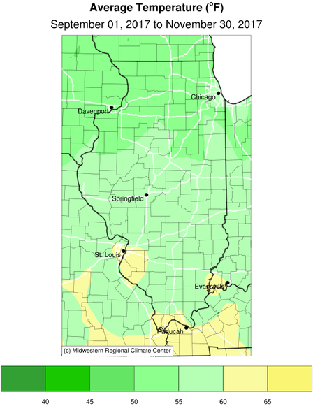
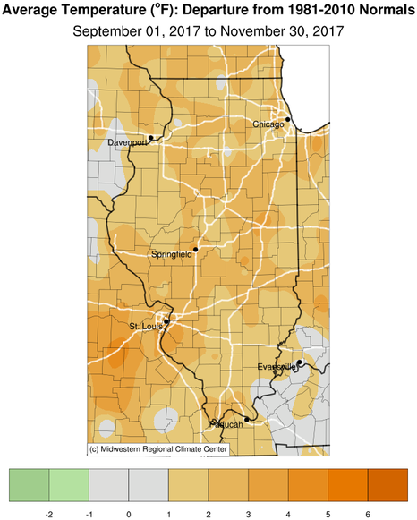
- Fall temperatures were 1 to 4 degrees above normal across central and southeast IL, with October being 3-5 degrees above normal.
- There were three days of severe weather reports in central IL during this past fall. On Labor Day evening Sep 4th there were 1 to 2 inch hail reports from Sangamon and Macon counties southward into Macoupin county. On Saturday evening Oct 14th there were several severe wind reports along and northwest of I-55. And on Sunday afternoon Nov 5th there were severe wind reports southeast of a Taylorville to Champaign line along with an EF1 tornado in Richland county.
- Many areas of central and western IL saw their 1st killing freeze early Sunday morning Oct 29th, about 2 weeks later than normal and nearly 2 weeks earlier than last fall. Eastern IL east of I-57 saw their 1st widespread killing freeze a couple days later on Halloween morning.
Fall 2017 Season Precipitation and Temperature Maps: