Overview
On the afternoon of Thursday, May 6th, thunderstorms developed along a cold front moving southeast through central Illinois. The storms became strong, producing hail, numerous funnel clouds, and four tornadoes. Most of the tornadoes were very brief, but one produced damage in Assumption, IL (Christian County). An NWS damage survey rated the Assumption tornado EF-0, with an estimated maximum peak wind of 75 mph. The other three tornadoes occurred over open field and were rated EF-Unknown. Additional details can be found on the Storm Reports tab.
Initial showers developed in McLean county around 11 AM local time, with additional development further southwest along and ahead of the cold front shortly thereafter. Around 1 PM, the Storm Prediction Center issued a mesoscale discussion highlighting the potential for landspouts in east-central Illinois in the afternoon. The environment was characterized by steep low level lapse rates (allowing for enhanced lift near the surface) and increased surface vorticity (spin) near the front.
The first tornado warning was issued for Shelby and Christian Counties at 2:16 PM after a trained spotter confirmed a tornado. At 2:29 PM, a tornado warning was issued for a different thunderstorm in Moultrie and Shelby Counties due to radar indicated rotation. Later in the afternoon, a tornado warning was issued for Clay County at 4:45 PM.
This story is preliminary and data is subject to change.
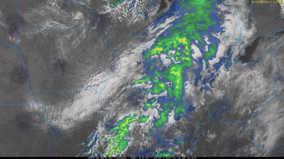
Satellite and Radar
Below is a visible satellite and composite reflectivity loop from 11:30 AM - 7:00 PM local time.
Localized Radar Loop
The radar loop below shows radar reflectivity from 1:43 to 3:10 PM local time, primarily between I-72 and I-70 where the strongest thunderstorms occurred during that time frame. A tornado occurred in Assumption at 1:55 PM, and multiple funnel clouds were reported in Moultrie and Shelby Counties between 2:20-2:40 PM. (In this loop, yellow boxes indicate severe thunderstorm warning and the red boxes indicate tornado warnings. County names are in light blue.)
.gif)
Photos & Video
May 6, 2021 Event Photos
 |
 |
 |
 |
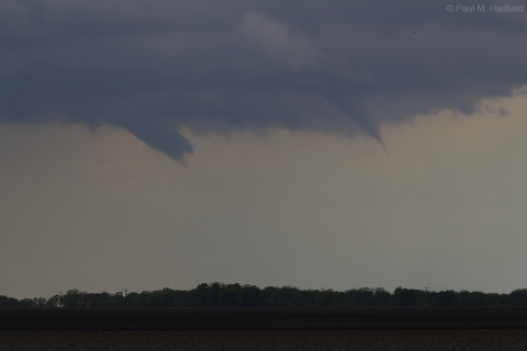
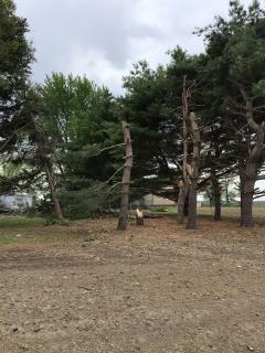
| Funnel clouds near Assumption, IL (Photo: Paul Hadfield) |
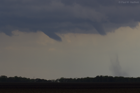
Funnel cloud (left) and tornado (right) near Assumption, IL (Photo: Paul Hadfield) |
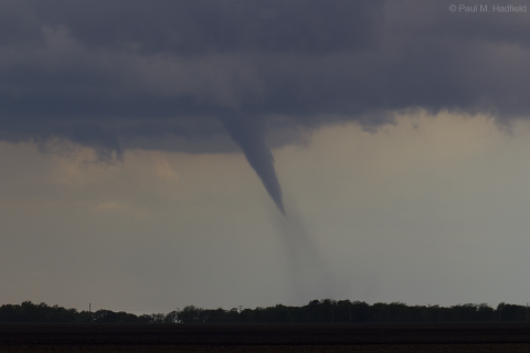
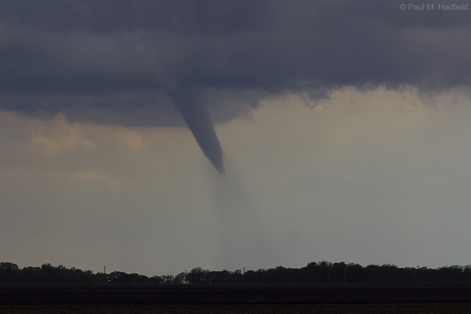
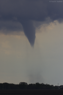
Tornado near Assumption, IL (Photo: Paul Hadfield) |
Tornado near Assumption, IL (Photo: Paul Hadfield) |
 |
 |
 |
 |
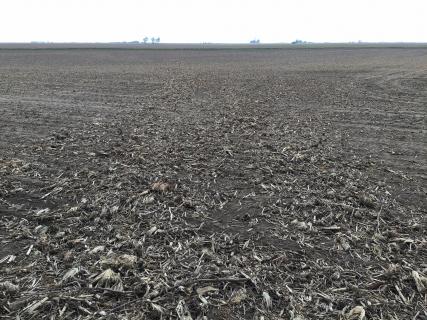
| Beginning of Assumption, IL, tornado track (Photo: NWS Lincoln) |
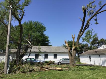
Tornado damage in Assumption, IL (Photo: NWS Lincoln) |
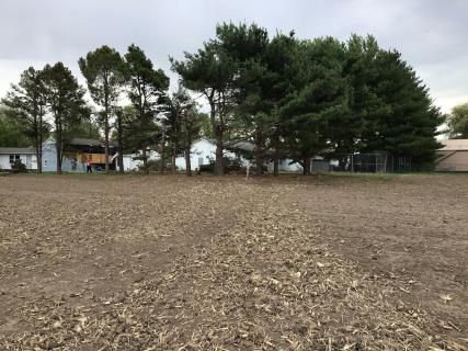
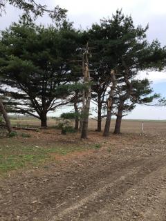
Tree damage from a tornado in Assumption, IL (Photo: NWS Lincoln) |
Tree damage from a tornado in Assumption, IL (Photo: NWS Lincoln) |
 |
 |
 |
 |
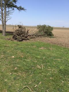
| Tree uprooted by tornado in Assumption, IL (Photo: NWS Lincoln) |
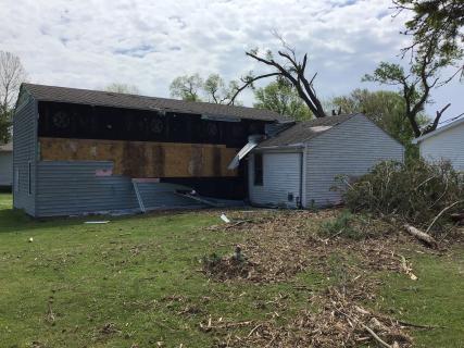
Tornado damage in Assumption, IL (Photo: NWS Lincoln) |
Tornado damage in Assumption, IL (Photo: NWS Lincoln) |
Tornado near Assumption, IL (Photo: Paul Hadfield) |
Storm Reports
This section contains a Public Information Statement which details the tornado reports, including the findings of the NWS damage survey, followed by a Local Storm Report Summary, which details all of the severe weather reports (tornadoes, funnels, hail) that occurred on May 6, 2021.
Public Information Statement

000
NOUS43 KILX 071732
PNSILX
ILZ027>031-036>038-040>057-061>063-066>068-071>073-080545-

PUBLIC INFORMATION STATEMENT
NATIONAL WEATHER SERVICE LINCOLN IL
1232 PM CDT FRI MAY 7 2021


...NWS DAMAGE SURVEY FOR MAY 6TH, 2021 TORNADO EVENT...


.ASSUMPTION (2SSW) TORNADO...

RATING:                 EF-0
ESTIMATED PEAK WIND:    75 MPH
PATH LENGTH /STATUTE/:  0.2 MILES
PATH WIDTH /MAXIMUM/:   20 YARDS
FATALITIES:             0
INJURIES:               0

START DATE:             MAY 06 2021
START TIME:             211 PM CDT
START LOCATION:         2 SSW ASSUMPTION
START LAT/LON:          39.4883 / -89.0665

END DATE:               MAY 06 2021
END TIME:               212 PM CDT
END LOCATION:           2 SSW ASSUMPTION
END LAT/LON:            39.4864 / -89.0644

SURVEY SUMMARY: MAINLY TREE DAMAGE ON THE NORTH EDGE OF THE
PROPERTY. SIDING WAS PARTIALLY RIPPED OF ONE BUILDING. A HOLE
WAS PUNCHED INTO A ROOF FROM A FALLING TREE LIMB. TORNADO BEGAN IN
THE FIELD TO THE NORTHWEST OF THE PROPERTY AND ENDED NEAR THE
PROPERTY LINE.


.ALTAMONT (2S) TORNADO...

RATING:                 EF-U
ESTIMATED PEAK WIND:    UNKNOWN
PATH LENGTH /STATUTE/:  ESTIMATED <0.1 MILES.
PATH WIDTH /MAXIMUM/:   ESTIMATED 20 YARDS
FATALITIES:             0
INJURIES:               0

START DATE:             MAY 06 2021
START TIME:             310 PM CDT
START LOCATION:         2 S ALTAMONT
START LAT/LON:          39.03 / -88.75

END DATE:               MAY 06 2021
END TIME:               311 PM CDT
END LOCATION:           2 S ALTAMONT
END LAT/LON:            UNKNOWN

SURVEY SUMMARY: FIRE DEPARTMENT REPORTED A BRIEF TOUCHDOWN. NO
KNOWN DAMAGE.


.EDGEWOOD (1NNE) TORNADO...

RATING:                 EF-U
ESTIMATED PEAK WIND:    UNKNOWN
PATH LENGTH /STATUTE/:  ESTIMATED <0.1 MILES.
PATH WIDTH /MAXIMUM/:   ESTIMATED 20 YARDS
FATALITIES:             0
INJURIES:               0

START DATE:             MAY 06 2021
START TIME:             0330 PM CDT
START LOCATION:         1 NNE EDGEWOOD
START LAT/LON:          38.94 / -88.66

END DATE:               MAY 06 2021
END TIME:               0331 PM CDT
END LOCATION:           1 NNE EDGEWOOD
END LAT/LON:            UNKNOWN

SURVEY SUMMARY: LOCAL LAW ENFORCEMENT REPORTED A BRIEF TOUCHDOWN
NEAR MILE MARKER 145 ON I-57. NO DAMAGE WAS REPORTED.


.NOBLE (2S) TORNADO...

RATING:                 EF-U
ESTIMATED PEAK WIND:    UNKNOWN
PATH LENGTH /STATUTE/:  ESTIMATED <0.1 MILES.
PATH WIDTH /MAXIMUM/:   ESTIMATED 20 YARDS
FATALITIES:             0
INJURIES:               0

START DATE:             MAY 06 2021
START TIME:             0501 PM CDT
START LOCATION:         2 S NOBLE
START LAT/LON:          38.66 / -88.22

END DATE:               MAY 06 2021
END TIME:               0502 PM CDT
END LOCATION:           2 S NOBLE
END LAT/LON:            UNKNOWN

SURVEY SUMMARY: LOCAL LAW ENFORCEMENT REPORTED A BRIEF TOUCHDOWN
NEAR COUNTY ROAD 400E ABOUT 2 MILES SOUTH OF NOBLE. NO DAMAGE
WAS REPORTED.


&&

EF SCALE: THE ENHANCED FUJITA SCALE CLASSIFIES TORNADOES INTO THE
FOLLOWING CATEGORIES:

EF0...WEAK......65 TO 85 MPH
EF1...WEAK......86 TO 110 MPH
EF2...STRONG....111 TO 135 MPH
EF3...STRONG....136 TO 165 MPH
EF4...VIOLENT...166 TO 200 MPH
EF5...VIOLENT...>200 MPH

NOTE:
THE INFORMATION IN THIS STATEMENT IS PRELIMINARY AND SUBJECT TO
CHANGE PENDING FINAL REVIEW OF THE EVENTS AND PUBLICATION IN NWS
STORM DATA.

$$

NWS CENTRAL ILLINOIS
Local Storm Report Summary
000
NWUS53 KILX 071325
LSRILX

PRELIMINARY LOCAL STORM REPORT...SUMMARY
NATIONAL WEATHER SERVICE LINCOLN IL
825 AM CDT FRI MAY 7 2021

..TIME...   ...EVENT...      ...CITY LOCATION...     ...LAT.LON...
..DATE...   ....MAG....      ..COUNTY LOCATION..ST.. ...SOURCE....
            ..REMARKS..

0124 PM     HAIL             3 ENE XENIA             38.65N 88.58W
05/06/2021  E1.00 INCH       CLAY               IL   PUBLIC

            VIA COUNTY ESDA, QUARTER SIZE HAIL REPORTED
            NEAR DOGWOOD RD AND OLD US 50.

0211 PM     TORNADO          ASSUMPTION              39.52N 89.05W
05/06/2021                   CHRISTIAN          IL   PUBLIC

            CORRECTS PREVIOUS TORNADO REPORT FROM
            ASSUMPTION. DAMAGE TO CHILDCARE FACILITY.
            LOCATED JUST SOUTH OF ASSUMPTION, MOVING
            SOUTHEAST. BRIEF TOUCHDOWN.

0221 PM     FUNNEL CLOUD     5 SW BETHANY            39.59N 88.81W
05/06/2021                   MOULTRIE           IL   STORM CHASER

            PHOTO FROM SOCIAL MEDIA INDICATES IT IS
            ABOUT HALFWAY TO THE GROUND.

0229 PM     FUNNEL CLOUD     SHELBYVILLE             39.41N 88.81W
05/06/2021                   SHELBY             IL   STORM CHASER


0240 PM     FUNNEL CLOUD     FINDLAY                 39.52N 88.75W
05/06/2021                   SHELBY             IL   STORM CHASER

            HIGH BASED FUNNEL.

0241 PM     HAIL             4 E HOOPESTON           40.47N 87.59W
05/06/2021  M1.00 INCH       VERMILION          IL   TRAINED SPOTTER


0307 PM     HAIL             2 ENE WINDSOR           39.45N 88.56W
05/06/2021  M0.70 INCH       MOULTRIE           IL   STORM CHASER

            DIME SIZE HAIL. CORRECTED LOCATION FROM 2
            ENE HOOPESTON.

0310 PM     FUNNEL CLOUD     ALTAMONT                39.06N 88.75W
05/06/2021                   EFFINGHAM          IL   STORM CHASER

            CLOSE TO TOUCHING THE GROUND.

0310 PM     TORNADO          2 S ALTAMONT            39.03N 88.75W
05/06/2021                   EFFINGHAM          IL   FIRE DEPT/RESCUE

            BRIEF TOUCHDOWN.

0330 PM     TORNADO          MASON                   38.95N 88.63W
05/06/2021                   EFFINGHAM          IL   LAW ENFORCEMENT

            BRIEF TOUCHDOWN, BUT WAS CLOSE TO TOUCHING
            DOWN AGAIN.

0340 PM     FUNNEL CLOUD     1 N IOLA                38.85N 88.63W
05/06/2021                   CLAY               IL   TRAINED SPOTTER

            UNABLE TO TELL IF IT WAS REACHING THE
            GROUND.

0501 PM     TORNADO          2 S NOBLE               38.66N 88.22W
05/06/2021                   RICHLAND           IL   LAW ENFORCEMENT

            LOCAL LAW ENFORCEMENT REPORTED A TORNADO
            BRIEFLY TOUCHED DOWN NEAR CR 400E SOUTH OF
            NOBLE. NO DAMAGE WAS REPORTED.


&&

$$
 |
Media use of NWS Web News Stories is encouraged! Please acknowledge the NWS as the source of any news information accessed from this site. |
|

