May Precipitation Highlights:
- Monthly rainfall was near normal over large portions of central IL, but ranged from 2" below normal in the southeast to an inch or two above normal in an area from Galesburg to Charleston. A few significant weather events occurred:
- May 3: A cold front and mesoscale convective vortex triggered a couple of supercell thunderstorms, including one that produced 5 brief tornado touchdowns and hail as large as golf balls along its track from Cass County into Coles County. All were rated at EF-U, or unknown, since no damage was observed.
- May 6: Four tornadoes were observed as a cold front crossed the area during the afternoon. Three EF-U and 1 EF-0 (2 SSW of Assumption) tornadoes were observed with thunderstorms from Assumption to Noble. In addition, there were several funnel cloud reports and hail up to 1 inch diameter.
- May 8-9: Heavy rain fell in areas mainly north of I-72 as a storm system tracked across IL. Numerous reports of over 2" to near 3" of rain were received .
- May 16-18: 1 1/2" up to 4" rain fell over much of central IL north of I-70 as a stalled frontal boundary affected the region.
- May 27: Following widespread moderate rainfall the previous few days, a few strong to severe thunderstorms produced areas of minor wind damage from near Jacksonville to Clay County and a couple of brief tornadoes in Clay County with minor damage.
 |
 |
May Temperature Highlights:
- Monthly average temperatures were 1 to 3 degrees below normal across most of central and southeast IL. The first half of the month saw an extended period of much below normal temperatures. The last half of the month saw a stretch of warmer than normal temperatures from the 20th to 26th to somewhat balance out the colder than normal month.
Climate Statistics:
|
Site
|
Precipitation
|
Departure from Normal |
Average Temperature
|
Departure from Normal |
|
Charleston
|
4.08" |
-0.44" |
61.3 |
-4.3 |
| Danville |
3.85" |
-0.78" |
60.5 |
-3.3
|
| Decatur |
5.61" |
+0.66" |
61.7 |
-2.0
|
| Effingham |
4.85"
|
-0.05" |
N/A |
N/A |
|
Flora
|
2.43" |
-2.66" |
63.1 |
-2.4 |
| Galesburg |
6.70" |
+1.43" |
59.7 |
-2.1
|
|
Havana
|
N/A |
N/A |
N/A |
N/A |
|
Jacksonville
|
6.70" |
+1.43" |
59.7 |
-2.1 |
|
Lincoln
|
4.11" |
-0.26" |
61.6 |
-2.0 |
|
Normal
|
6.22" |
+1.41" |
59.3 |
-2.6 |
|
Olney
|
3.42" |
-2.18" |
62.1 |
-2.1 |
|
Paris
|
3.97" |
-0.20" |
58.4 |
-3.7 |
|
Peoria
|
6.35" |
+1.66" |
61.2 |
-2.3 |
| Springfield |
6.05"
|
+1.53" |
62.5 |
-2.6 |
|
Tuscola
|
3.51" |
-0.73" |
61.1 |
-2.5 |
| Urbana |
3.51" |
-1.27" |
61.2 |
-2.0
|
The following links are the monthly climate summaries for area cities. Only the summaries for Peoria, Springfield, and Lincoln are considered "official", meaning they are the station of record for their respective locations. The other summaries are "supplemental", meaning another location in the area is the official climate station for the city.
- Peoria -- Peoria International Airport
- Springfield -- Abraham Lincoln Capital Airport
- Lincoln -- National Weather Service Office
- Champaign -- University of Illinois-Willard Airport
- Decatur -- Decatur Airport
- Lawrenceville -- Lawrenceville-Vincennes International Airport
- Mattoon -- Coles County Memorial Airport
Climate data for other cities is available at http://w2.weather.gov/climate/xmacis.php?wfo=ilx
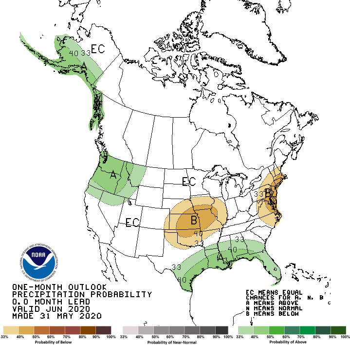
June Look Ahead:
- Official outlooks from NOAA's Climate Predication center show near to above normal temperatures favored for the area,
and a trend towards near normal rainfall in central IL and trending toward above normal rainfall in southeast IL.
---------------------------------------------------------------------------------------------------------------------------------------------------------
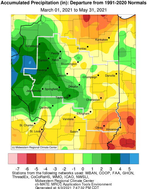
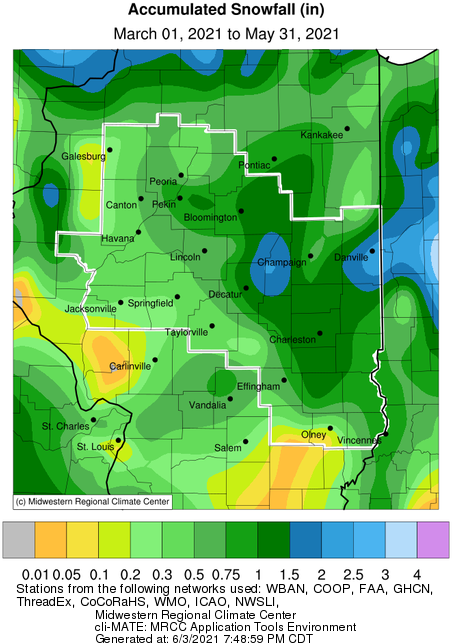
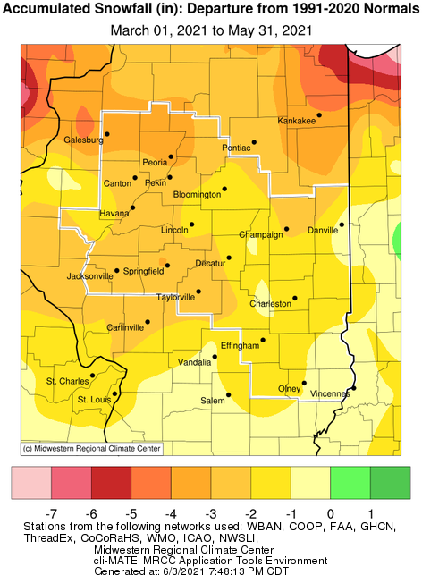
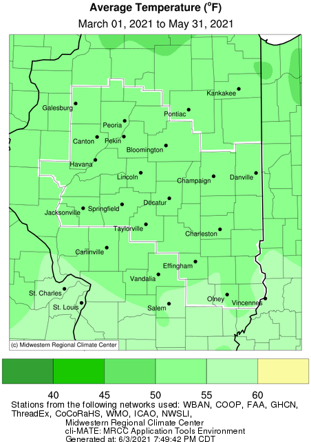
Spring Season Overview
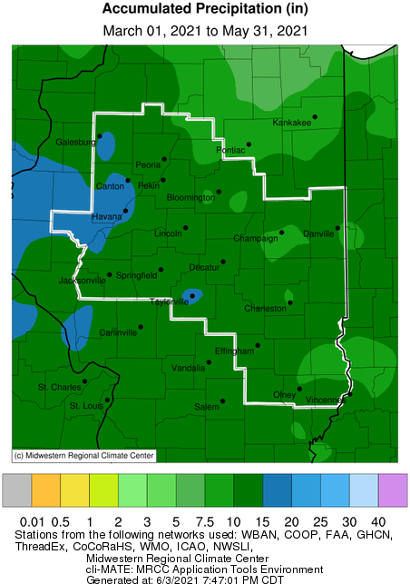
- March through May saw above normal precipitation in west central IL and below normal precipitation in east central and southeast IL. Differences from normal ranged up to around 4 inches.
- Seasonal snowfall ranged only up to around 2 inches, and was generally 1 to 3 inches below normal.
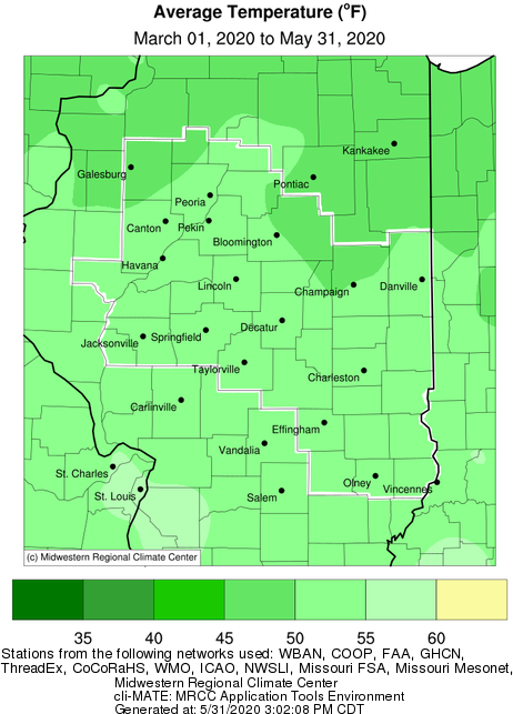
- Seasonal temperatures were near to slightly below normal across the area.
Spring Season: Precipitation, Snowfall, Temperature, and Departure from Normal Maps

Links below are the seasonal climate summaries for area cities. Only the summaries for Peoria, Springfield and Lincoln are considered "official", meaning they are the station of record for their respective locations. The other summaries are "supplemental", meaning another location in the area is the official climate station for that city.
Climate data for other area cities is available at http://w2.weather.gov/climate/xmacis.php?wfo=ilx