Central Illinois
Weather Forecast Office
Overview
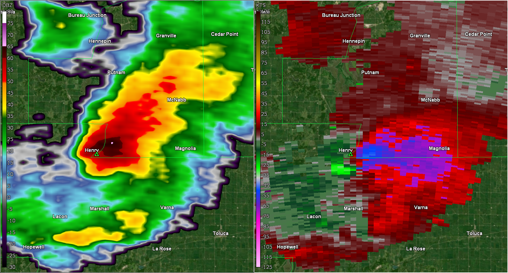
A small complex of fast-moving storms developed late in the afternoon on Thursday Feb 8th, 2024. Environmental parameters were supportive of strong storms across north-central Illinois, with a few of them developing rotation as observed by the NWS Lincoln WSR-88D doppler radar. The storms initially produced hail, with sizes ranging from peas to one inch. One storm intensified to the point of producing a tornado in northern Marshall County, around 2 miles south of Henry. The tornado moved at 45 mph to the northeast, crossing into Putnam county around 4:44 PM CST. The tornado damaged some grain bins and outbuildings along with uprooting or snapping several large trees along it's nearly 10 mile path.Tornadoes
|
Henry Tornado
|
||||||||||||||||
The Enhanced Fujita (EF) Scale classifies tornadoes into the following categories:
| EF0 Weak 65-85 mph |
EF1 Moderate 86-110 mph |
EF2 Significant 111-135 mph |
EF3 Severe 136-165 mph |
EF4 Extreme 166-200 mph |
EF5 Catastrophic 200+ mph |
 |
|||||
Radar
Header
 |
 |
 |
 |
| 4:37 PM - 3 mins before tornado development | 4:40 PM CT - Time of tornado touchdown | 4:42 PM CT - 2 minutes after tornado touchdown | 4:44 PM CT - 4 minutes after touchdown and the time it crossed into Putnam County |
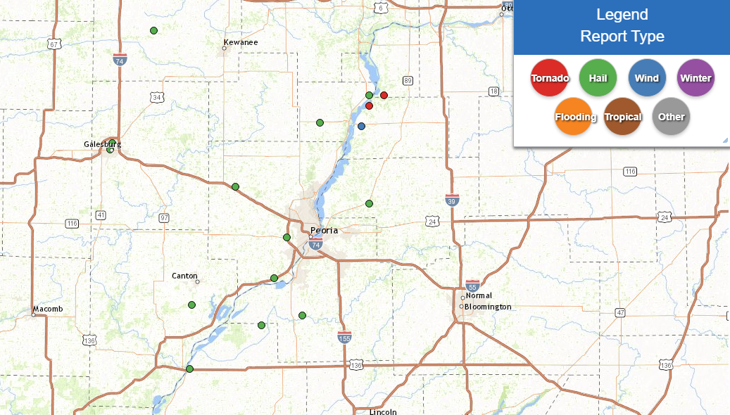
Storm Reports
NWUS53 KILX 090144
LSRILX

Preliminary Local Storm Report...Summary
National Weather Service Lincoln IL
744 PM CST Thu Feb 8 2024

..TIME...   ...EVENT...      ...CITY LOCATION...     ...LAT.LON...
..DATE...   ....MAG....      ..COUNTY LOCATION..ST.. ...SOURCE....
            ..REMARKS..

0440 PM     Tornado          2 S Henry               41.08N 89.36W
02/08/2024  EF1              Marshall           IL   NWS Storm Survey

            Tornado developed 2 miles south of Henry and
            tracked northeast through rural portions of
            northern Marshall and southeast Putnam
            Counties, damaging trees and outbuildings.
            The tornado dissipated 2 miles south of
            McNabb. Path length 9.9 miles, max width 100
            yards. Max wind speed estimated 110 mph.
            This updates previous LSR.
0541 PM     Hail             3 SE South Pekin        40.46N 89.62W
02/08/2024  E0.88 inch       Tazewell           IL   Emergency Mngr


0540 PM     Hail             Metamora                40.79N 89.36W
02/08/2024  E0.88 inch       Woodford           IL   Emergency Mngr


0530 PM     Hail             Manito                  40.43N 89.78W
02/08/2024  E0.88 inch       Mason              IL   Broadcast Media

            Pea to nickel size hail.

0520 PM     Hail             Bellevue                40.69N 89.68W
02/08/2024  E1.00 inch       Peoria             IL   Public


0517 PM     Hail             Havana                  40.30N 90.06W
02/08/2024  E0.70 inch       Mason              IL   Public

            Photo from social media.

0510 PM     Hail             Mapleton                40.57N 89.73W
02/08/2024  E1.00 inch       Peoria             IL   Broadcast Media

            Time estimated from radar.

0453 PM     Tstm Wnd Gst     Marshall County Airport 41.02N 89.39W
02/08/2024  M63 MPH          Marshall           IL   AWOS

            REPORTED AT KC75.

0445 PM     Hail             Saint David             40.49N 90.05W
02/08/2024  M0.75 inch       Fulton             IL   Public


0442 PM     Tornado          2 S Henry               41.08N 89.36W
02/08/2024                   Marshall           IL   Broadcast Media

            Brief touchdown in open field.

0442 PM     Hail             Henry                   41.11N 89.36W
02/08/2024  E0.75 inch       Marshall           IL   Trained Spotter


0419 PM     Hail             5 SE Camp Grove         41.03N 89.55W
02/08/2024  E0.75 inch       Marshall           IL   Public

            Report from mPING: Dime (0.75 in.).

0351 PM     Hail             Brimfield               40.84N 89.88W
02/08/2024  E0.75 inch       Peoria             IL   Public

            Report from mPING: Dime (0.75 in.).

0349 PM     Hail             Brimfield               40.84N 89.88W
02/08/2024  M0.88 inch       Peoria             IL   Broadcast Media


0342 PM     Hail             1 N Galesburg           40.97N 90.36W
02/08/2024  E0.50 inch       Knox               IL   Public

            Report from mPING: Half-inch (0.50 in.).

0338 PM     Hail             Galesburg               40.95N 90.37W
02/08/2024  M0.75 inch       Knox               IL   Broadcast Media
 |
Media use of NWS Web News Stories is encouraged! Please acknowledge the NWS as the source of any news information accessed from this site. |
|
US Dept of Commerce
National Oceanic and Atmospheric Administration
National Weather Service
Central Illinois
1362 State Route 10
Lincoln, IL 62656
217-732-7321 (forecast recording) or 217-732-3089
Comments? Questions? Please Contact Us.
Thank you for visiting a National Oceanic and Atmospheric Administration (NOAA) website. The link you have selected will take you to a non-U.S. Government website for additional information.
NOAA is not responsible for the content of any linked website not operated by NOAA. This link is provided solely for your information and convenience, and does not imply any endorsement by NOAA or the U.S. Department of Commerce of the linked website or any information, products, or services contained therein.
You will be redirected to:


