Overview
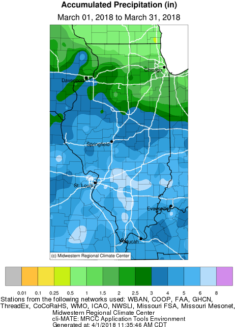
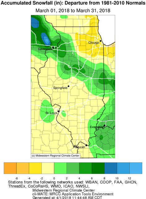
March saw below normal temperatures and above normal precipitation across central and southeast Illinois. A predominant northwest flow across the Midwest, kept daily temperatures several degrees below normal for most days. A few significant weather systems brought locally heavy rain to the area and pushed many rivers into flood. While much of the area saw no snowfall in March, a late season winter storm brought heavy snow to locations along and north of I-74 on March 23-24. The mildest days during this month were on Thursday March 15th and Saturday March 31st. Here are some highlights of two of the most significant weather events:
______________________________________________________________________________________________________________
Precipitation, Snowfall, Temperature, and Departure from Normal Maps


_____________________________________________________________________________________________________________

___________________________________________________________________________________________________________

___________________________________________________________________________________________________________
Climate Data
|
Site |
Precipitation |
Departure from Normal | Snowfall |
Departure |
Average Temperature |
Departure from Normal |
|
Charleston |
5.14" | +2.25" | T | -1.8" | 38.5F | -4.9F |
|
Clinton |
N/A | N/A | N/A | N/A | N/A | N/A |
| Danville |
4.42" |
+1.40" | 5.0" | +2.3" | 38.5F | -3.5F |
| Decatur |
3.50" |
+0.91" | T | -1.7" | 38.6F | -4.1F |
| Effingham |
5.95" |
+2.68" | 0.6" | -1.1" | 40.8F | -1.4F |
|
Flora |
6.19" | +2.27" | N/A | N/A | 41.4F | -2.1F |
| Galesburg |
2.73" |
-0.03" | 2.0" | -0.0" | 35.9F | -2.1F |
|
Havana |
4.40" | +1.59" | T | -3.1" | N/A | N/A |
|
Jacksonville |
4.15" | +1.09" | 0.4" | -1.9" | 39.0F | -2.7F |
|
Lacon |
2.04" | -1.01" | 2.5" | -0.5" | N/A | N/A |
| Lincoln | 4.27" | +1.67" | 0.3" | -1.4" | 38.1F | -3.0F |
|
Minonk |
2.54" | -0.28" | 10.5" | +7.7" | 36.1F | -2.6F |
|
Morton |
4.04" | +1.14" | 7.1" | +4.5" | N/A | N/A |
|
Normal |
3.21" |
+0.50" | 8.5" | +7.0" | 35.8F | -2.4F |
|
Olney |
5.82" | +1.48" | 0.0" | -1.1" | 41.1F | -1.8F |
|
Paris |
4.81" | +1.91" | 1.4" | -1.2" | 37.1F | -3.8F |
| Peoria |
3.72" |
+0.92" | 9.3" | +6.6" | 38.6F | -2.0F |
|
Rushville |
5.52" | +2.92" | N/A | N/A | N/A | N/A |
|
Shelbyville |
4.10" | +1.37" | T | N/A | 39.9F | -1.9F |
| Springfield |
4.36" |
+1.73" | T | -2.5" | 40.6F | -1.5F |
|
Sullivan |
3.72" | +1.13" | T | -1.1" | 38.6F | -1.8F |
|
Tuscola |
3.50" | +0.69" | T | -2.0" | 38.2F | -2.1F |
| Urbana |
3.27" |
+0.41" | 2.8" | +0.2" | 38.0F | -2.0F |
Links below are the monthly climate summaries for area cities. Only the summaries for Peoria, Springfield and Lincoln are considered "official", meaning they are the station of record for their respective locations. The other summaries are "supplemental", meaning another location in the area is the official climate station for that city.
Climate data for other area cities is available at http://www.nws.noaa.gov/climate/xmacis.php?wfo=ilx

