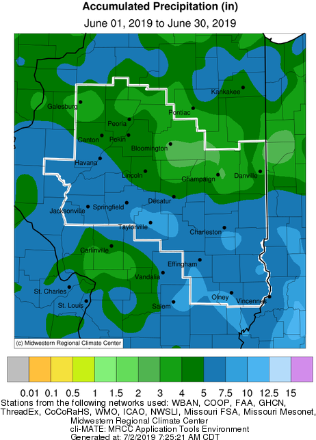
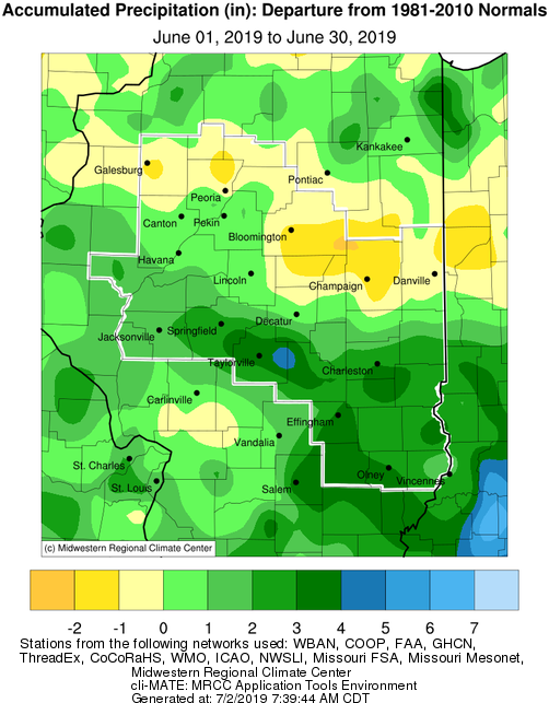
June Precipitation Highlights:
- An active weather pattern persisted over central and southeast Illinois for much of the month. Monthly rain totals were well above normal, south of a Peoria, to Decatur, to Paris line. The highest surpluses were south of a Springfield, to Taylorville, to Charleston line, where monthly surpluses of 2-4" were common. Areas along on north of the I-74 corridor saw below normal rainfall, with 1-2" deficits. Several heavy rainfall events affected the area and led to numerous reports of flash flooding.
- June 14-16: Several rounds of showers and thunderstorms impacted central Illinois during the Father's Day weekend. The heaviest rain during that period fell near the I-70 corridor, where widespread amounts of 2 to 3 inches occurred. A few localized spots south of Charleston-Mattoon and south of Effingham picked up in excess of 4 inches. Meanwhile further north, locations along and north of the I-74 corridor generally saw less than 1 inch.
- June 19: Low pressure tracking along the I-70 corridor brought periods of showers and thunderstorms to central Illinois during the afternoon and evening of June 19th. While the bulk of the severe weather remained well south of the area, a few cells produced damaging wind gusts and localized flash flooding. One storm produced a brief very weak tornado west of Moweaqua in far eastern Christian County and just east of Bethany in western Moultrie County. No damage was reported with either touchdown. Another storm caused 60 mph wind gusts and minor wind damage in Robinson in Crawford County. The main weather story of the day was the heavy rain, as several pockets of rainfall in excess of 2 inches were observed.
- June 21-23: Heavy rainfall impacted portions of central Illinois this weekend, with the heaviest rain occurring along and south of a Macomb, to Lincoln, to Mattoon line on Friday, June 21st. A squall line advanced southeastward across this part of the state from midday Friday through the afternoon, producing gusty winds, frequent lightning, and torrential downpours. Additional thunderstorm activity developed late Friday night into Saturday, putting more rain down on already water-logged locations. This led to flooding across portions of eastern Morgan, central Sangamon, Christian, and western Shelby counties where some spots picked up in excess of 3 inches of rain.
 |
 |
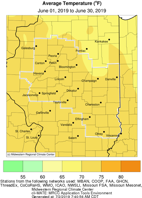
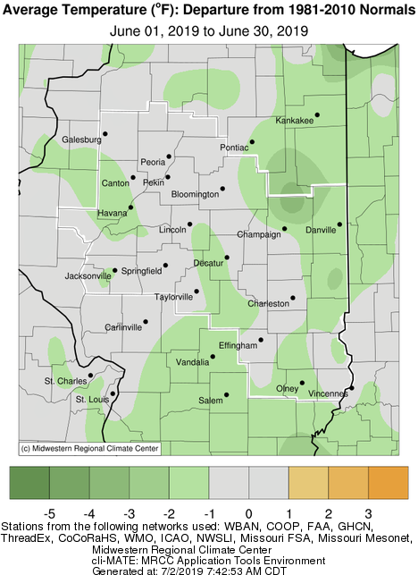
June Temperature Highlights:
- Monthly average temperatures were 1 to 2 degrees below normal across much of the area. A lack of typical summertime heat and humidity was observed for most of the month, until the 29th-30th, when widespread 90+ degree highs were reported.
June Climate Statistics:
|
City
|
Precipitation
|
Departure from Normal |
Average Temperature
|
Departure from Normal |
|
Charleston
|
7.43" |
+3.08" |
73.1 |
0.0 |
| Danville |
4.89"
|
+0.44" |
71.0 |
-1.1 |
|
Decatur
|
5.11" |
+0.61" |
71.5 |
-1.8 |
| Effingham |
6.27"
|
+1.81" |
72.5 |
-0.4 |
|
Flora
|
7.38" |
+3.20" |
73.4 |
-0.7 |
|
Galesburg
|
2.90" |
-0.40" |
70.7 |
-0.4 |
|
Havana
|
3.85" |
-0.51" |
N/A |
N/A |
|
Jacksonville
|
5.58" |
+1.10" |
71.6 |
-1.4 |
|
Lincoln
|
5.17" |
+0.85" |
71.2 |
-0.9 |
|
Normal
|
3.45"
|
-0.46" |
70.6 |
-0.8 |
|
Olney
|
8.46" |
+4.27" |
71.7 |
-1.7 |
|
Paris
|
7.30" |
+2.95" |
70.1 |
-2.4 |
|
Peoria
|
5.17" |
+1.64" |
71.7 |
-0.1 |
| Springfield |
7.14"
|
+2.68" |
72.2 |
-0.3 |
| Taylorville |
8.50" |
+4.11" |
N/A |
N/A |
|
Tuscola
|
5.00" |
+0.56" |
71.9 |
-0.9 |
|
Urbana
|
2.82" |
-1.52" |
71.4 |
-0.8 |
The following links are the monthly climate summaries for area cities. Only the summaries for Peoria, Springfield, and Lincoln are considered "official", meaning they are the station of record for their respective locations. The other summaries are "supplemental", meaning another location in the area is the official climate station for the city.
- Peoria -- Peoria International Airport
- Springfield -- Abraham Lincoln Capital Airport
- Lincoln -- National Weather Service Office
- Champaign -- University of Illinois-Willard Airport
- Decatur -- Decatur Airport
- Lawrenceville -- Lawrenceville-Vincennes International Airport
- Mattoon -- Coles County Memorial Airport
Climate data for other cities is available at http://w2.weather.gov/climate/xmacis.php?wfo=ilx