July Precipitation Highlights:
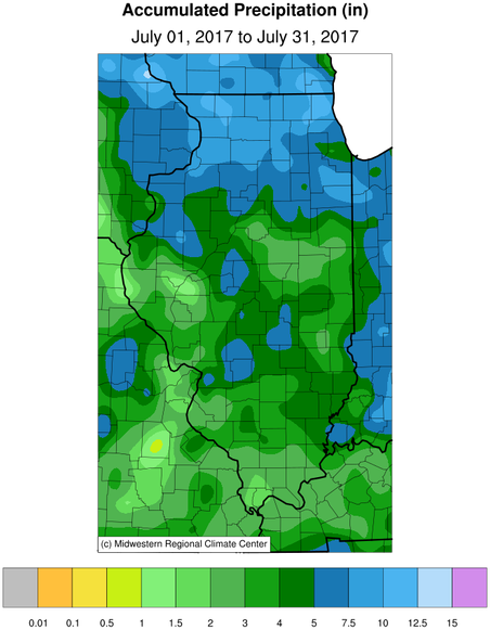
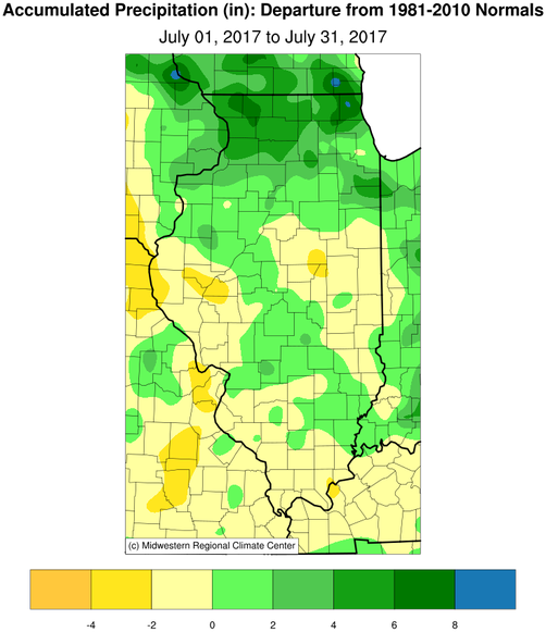
- While rainfall was more abundant than what was seen in June, July still ended up with below normal rainfall for much of central and southeast IL. Much of west-central and east-central IL saw deficits of one half, to nearly two inches. The exception was a narrow corridor extending from near Galesburg, southeast through Effingham, where totals were up to an inch above normal. These amounts of rain did not allow for much recovery from the dry conditions in June. An area stretching east from Rushville and Jacksonville, through Bloomington and Champaign, is classified as "abnormally dry" on the latest U.S. Drought Monitor.
July Temperature Highlights:
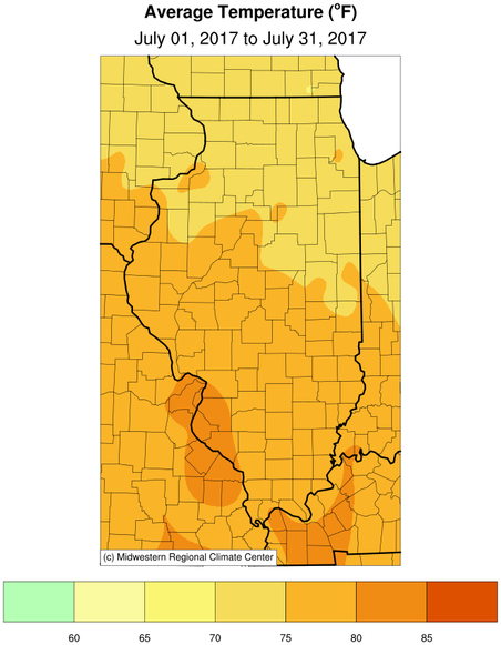
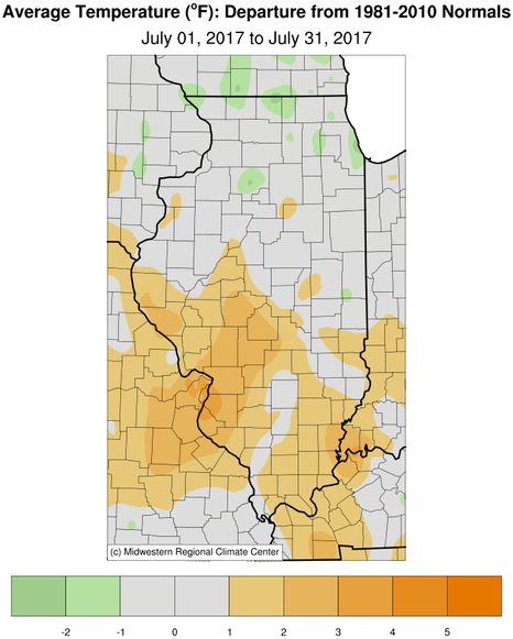
- Monthly average temperatures were near, to a couple degrees above normal across the region. Portions of west central and southwest Illinois saw the largest anomaly, with readings up to two degrees above normal. While periods of typical July heat were seen periodically through the month, a notable hot stretch occurred on the 18th-23rd. Many days during this period saw highs in the mid-90s, combined with dew points of 75-80 degrees. This produced peak afternoon heat indices of 105-110 degrees over much of the area.
July Weather Event Highlights:
- Thunderstorms developed rapidly in west central Illinois from about Monmouth to northwest of Peoria during the late afternoon of July 10th. The storms interacted with a front which was draped from northwest to southeast nearly parallel with I-74. One storm produced a tornado in northern Peoria County around 5:45 pm. Other thunderstorms rapidly clustered together and sank southward, producing large hail and damaging winds gusts in parts of central Illinois between 6:30 pm and 11:00 pm. Hardest hit areas included locations from southwest of Peoria - near Hanna City - toward northern Fulton County, down to Lincoln and much of Logan County.
- Significant rainfall occurred across much of central and southeast Illinois during the evening of July 26th into the early morning hours of July 27th. The heaviest rain fell from near Springfield southeastward to Effingham and Flora, where widespread amounts in excess of 2 inches were reported. The highest total came from Shelbyville and near Windsor with 3.17". Despite this widespread event, a few areas missed out on the beneficial rains. Most notably east-central Illinois along and east of a Champaign to Paris line where amounts were less than one quarter of an inch.
Rainfall and Temperature Maps:


Climatological Statistics:
The following links are the monthly and seasonal climate summaries for area cities. Only the summaries for Peoria, Springfield, and Lincoln are considered "official", meaning they are the station of record for their respective locations. The other summaries are "supplemental", meaning another location in the area is the official climate station for the city.
Climate data for other cities is available at https://www.weather.gov/climate/xmacis.php?wfo=ilx