A strong winter storm pushed through the Central US from February 14-16 bringing winter weather as far south as coastal Texas. With very cold surface temperatures already in place, the majority of the Midwest remained on the cold side of the system. Mixed precipitation fell along the Ohio River Valley and rain further south into the Southern Atlantic states. In central Illinois, snow accumulations of 6" or more were common. Roads and highways became snow packed and strong northerly winds gusting up to 25 mph contributed to poor driving conditions with blowing and drifting snow. Travel across the state of Illinois became very hazardous on the evening of Monday, February 15. If snow wasn't enough, very cold temperatures were intensified by gusty conditions forcing wind chills below -15°F across central Illinois. Overall, the system lead to significant and memorable impacts. Climatologically, Lincoln and Peoria broke records for total daily snowfall and many cities set new temperature records.
Climate Records
A number of records were set at the three official central Illinois climate sites:
February 14
February 15
February 16
Statewide Map of Snow Totals from NWS Local Storm Reports:Central Illinois Snow Map from Midwestern Regional Climate Center:
Snow Reports The following reports are storm total snowfall reports from February 14-16, 2021. Blowing and drifting made it challenging to measure. We thank all who submitted reports during this event! ...FEBRUARY 14-16 2021 SNOWFALL REPORTS... Location Amount Time/Date Provider ...Illinois... ...Champaign County... 2 SSE Urbana 11.9 in 0800 AM 02/16 COCORAHS Broadlands 10.4 in 1200 AM 02/16 COCORAHS 2 N Homer 10.1 in 0930 PM 02/15 Trained Spotter 1 NE Urbana 10.0 in 1030 PM 02/15 Public Homer 0.6 NNW 9.7 in 0635 AM 02/16 COCORAHS 2 N Homer 9.5 in 0700 AM 02/16 COCORAHS 2 S Champaign 9.5 in 0900 AM 02/16 COCORAHS 1 SSE Savoy 9.5 in 0700 AM 02/16 COCORAHS 2 SE Urbana 9.4 in 0700 AM 02/16 COCORAHS 1 SSE Urbana 9.2 in 0700 AM 02/16 COCORAHS Philo 9.0 in 0700 AM 02/16 COOP 2 SSE Urbana 9.0 in 0700 AM 02/16 COCORAHS Ogden 8.1 in 0600 AM 02/16 COOP 1 SSE Champaign 8.0 in 0738 AM 02/16 Public 2 ENE Urbana 7.9 in 0700 AM 02/16 COCORAHS 2 SW Champaign 7.9 in 1120 PM 02/15 Public 1 N Savoy 7.8 in 1000 AM 02/16 COCORAHS 2 SW Champaign 7.8 in 0900 AM 02/16 COCORAHS Thomasboro 7.7 in 1000 PM 02/15 Public 2 SE Urbana 7.5 in 1100 PM 02/15 Trained Spotter 2 SSE Champaign 7.0 in 0800 AM 02/16 COCORAHS 3 S Champaign 7.0 in 0700 AM 02/16 COOP 2 E Mahomet 6.9 in 0700 AM 02/16 COCORAHS 1 NNE Champaign 5.0 in 0600 AM 02/16 COCORAHS ...Christian County... Pana 9.3 in 0800 AM 02/16 Public Morrisonville 8.1 in 0730 AM 02/16 COCORAHS 6 NNE Pana 7.9 in 0700 AM 02/16 COCORAHS 2 SE Taylorville 6.9 in 0800 AM 02/16 COOP Assumption 6.5 in 0800 AM 02/16 Public 2 SW Rosamond 5.4 in 1200 PM 02/17 Mesonet Pana 5.0 in 0700 AM 02/16 COOP 1 ENE Taylorville 4.9 in 0700 AM 02/16 COCORAHS 3 W Edinburg 3.9 in 0700 AM 02/16 COCORAHS ...Clay County... Flora 10.0 in 0630 AM 02/16 COOP Clay City 6 SSE 9.0 in 0700 AM 02/16 COOP Flora 7.5 in 0743 AM 02/16 Public ...Coles County... Mattoon 11.5 in 0930 PM 02/15 Public 5 SSW Charleston 10.9 in 0800 AM 02/16 COCORAHS Charleston 10.0 in 0200 AM 02/16 Broadcast Media Cooks Mill 10.0 in 1000 PM 02/15 Public 1 NW Mattoon 9.5 in 1030 AM 02/16 Trained Spotter Mattoon 8.8 in 0700 AM 02/16 COOP ...Crawford County... 3 W Robinson 11.0 in 0754 AM 02/16 Public Palestine 9.7 in 0200 PM 02/16 COCORAHS Robinson 7.0 in 0740 AM 02/16 Public ...Cumberland County... 3 N Neoga 10.9 in 1040 PM 02/15 Public Toledo 9.5 in 0910 PM 02/15 Public Casey 9.1 in 0730 AM 02/16 COOP ...De Witt County... 3 WSW Farmer City 8.5 in 0700 AM 02/16 COCORAHS 1 SW Clinton 7.5 in 0737 AM 02/16 Public Clinton 7.5 in 0733 AM 02/16 Mesonet Clinton 7.3 in 0800 AM 02/16 COCORAHS Lane 6.0 in 1000 AM 02/17 Mesonet ...Douglas County... Arcola 10.5 in 0930 PM 02/15 Public Tuscola 10.0 in 0930 PM 02/15 Public Tuscola 9.1 in 0700 AM 02/16 COOP Arthur 9.0 in 0724 AM 02/16 Public ...Edgar County... 4 NNE Dennison 9.0 in 0700 AM 02/16 Broadcast Media Paris 9.0 in 0700 AM 02/16 COOP Redmon 9.0 in 1000 PM 02/15 Public ...Effingham County... Effingham 11.3 in 0736 AM 02/16 Public Effingham 10.2 in 0950 PM 02/15 Mesonet 4 SSW Altamont 9.5 in 0745 AM 02/16 COCORAHS Beecher City 9.2 in 1239 PM 02/16 COOP Watson 8.3 in 0400 AM 02/16 Mesonet SE Effingham 7.7 in 0700 AM 02/16 COOP ...Fulton County... 2 S Prairie City 3.8 in 0700 AM 02/16 COOP ...Jasper County... 6 NNE Newton 10.6 in 0900 AM 02/16 COCORAHS Newton 9.7 in 1200 AM 02/16 COOP ...Knox County... Galesburg 4.0 in 1030 AM 02/16 Public Galesburg 4.0 in 0700 AM 02/16 COOP Yates City 3.0 in 0700 AM 02/16 COOP 1 NW Knoxville 2.6 in 0700 AM 02/16 COCORAHS ...Lawrence County... 2 W Lawrenceville 11.2 in 0800 AM 02/16 COOP Sumner 6.0 in 0915 AM 02/16 Mesonet 3 W Birds 5.5 in 0735 AM 02/16 Public ...Logan County... Mount Pulaski 6.3 in 0600 AM 02/16 COOP New Holland 6.2 in 0700 AM 02/16 COCORAHS 4 SW Beason 5.5 in 0600 AM 02/16 COCORAHS NWS Lincoln 5.4 in 0600 AM 02/16 NWS Employee 3 E Hartsburg 3.0 in 0700 AM 02/16 COCORAHS ...Macon County... Decatur 8.0 in 0730 AM 02/16 COCORAHS Decatur 7.6 in 0240 AM 02/16 Broadcast Media 1 S Forsyth 4.5 in 0739 AM 02/16 Public 1 S Oreana 3.2 in 0800 AM 02/16 COCORAHS ...Mason County... Manito 3.0 in 0839 AM 02/16 Public ...McLean County... 2 E Normal 9.0 in 0900 AM 02/16 COCORAHS 1 E Heyworth 8.2 in 0800 AM 02/16 COCORAHS 2 WSW Bloomington 7.8 in 0730 AM 02/16 COCORAHS 2 NW Downs 7.0 in 1020 AM 02/16 Public 2 E Bloomington 7.0 in 0831 AM 02/16 NWS Employee 3 NE Bloomington 7.0 in 0700 AM 02/16 COCORAHS 4 NE Normal 6.8 in 0500 AM 02/16 COOP 3 SW Bloomington 6.4 in 0900 AM 02/16 NWS Employee 2 WNW Danvers 5.3 in 0700 AM 02/16 COCORAHS 1 SSE Normal 5.3 in 0700 AM 02/16 COCORAHS 4 SSW Le Roy 3.8 in 0700 AM 02/16 COCORAHS 4 ESE Bloomington 3.0 in 0600 AM 02/16 COCORAHS Chenoa 3.0 in 0700 AM 02/16 COOP ...Menard County... 1 N Athens 8.4 in 0700 AM 02/16 COCORAHS 7 SSE Petersburg 5.3 in 0700 AM 02/16 COCORAHS 4 SW Athens 5.1 in 0700 AM 02/16 COOP ...Morgan County... S Jacksonville 5.0 in 0725 AM 02/16 COCORAHS Jacksonville 4.0 in 0700 AM 02/16 COOP 3 SE Jacksonville 3.9 in 0700 AM 02/16 COCORAHS 1 SW Jacksonville 2.5 in 0900 AM 02/16 COCORAHS ...Moultrie County... 2 E Sullivan 10.0 in 0807 AM 02/16 Public Lovington 8.8 in 0700 AM 02/16 COOP 3 S Sullivan 6.5 in 0700 AM 02/16 COOP ...Peoria County... Peoria 6.1 in 0600 AM 02/16 COOP 5 NW Peoria 5.4 in 0800 AM 02/16 COOP 3 WNW Peoria 5.2 in 0700 AM 02/16 COCORAHS 4 SSW Alta 5.0 in 0830 AM 02/16 NWS Employee 1 SE Alta 5.0 in 0340 AM 02/16 Broadcast Media Elmwood 3.2 in 0700 AM 02/16 COCORAHS ...Piatt County... Atwood 9.0 in 1200 AM 02/16 Public 3 NNE Monticello 8.2 in 0800 AM 02/16 COCORAHS Cisco 7.6 in 0700 AM 02/16 COOP Cisco 7.5 in 0742 AM 02/16 Public 3 WSW Mansfield 5.0 in 0700 AM 02/16 COCORAHS ...Richland County... 2 NE Olney 11.8 in 0800 AM 02/16 COCORAHS 2 S Olney 11.5 in 0700 AM 02/16 COOP 1 E Dundas 11.5 in 0800 AM 02/16 COCORAHS ...Sangamon County... Chatham 10.0 in 0945 AM 02/16 Trained Spotter 3 NW Springfield 8.0 in 0700 AM 02/16 COCORAHS 2 W Riverton 7.6 in 0700 AM 02/16 COCORAHS 2 E Chatham 7.4 in 0700 AM 02/16 COCORAHS 4 W Springfield 7.2 in 0700 AM 02/16 COCORAHS 1 N Petersburg 7.0 in 0700 AM 02/16 COOP 3 NNE Curran 6.3 in 0833 AM 02/16 Mesonet 2 NNW Leland Grove 6.2 in 0700 AM 02/16 Public 1 ESE Chatham 6.0 in 0800 AM 02/16 NWS Employee Springfield 5.8 in 1200 AM 02/16 COOP ...Schuyler County... 1 WSW Rushville 5.2 in 0749 AM 02/16 Public ...Shelby County... 4 NW Mode 10.8 in 0700 AM 02/16 COCORAHS 1 E Shelbyville 9.5 in 0830 AM 02/16 COOP Windsor 9.0 in 0630 AM 02/16 COOP 2 S Moweaqua 5.0 in 0600 AM 02/16 COOP ...Tazewell County... Pekin 6.8 in 1125 AM 02/16 Broadcast Media Mackinaw 6.8 in 1120 PM 02/15 Public 1 S Morton 6.0 in 0700 AM 02/16 COCORAHS 2 NE Washington 6.0 in 0700 AM 02/16 COCORAHS 4 SE Pekin 6.0 in 0900 AM 02/16 COCORAHS Morton 5.6 in 0700 AM 02/16 COOP 6 N Manito 4.5 in 0700 AM 02/16 COCORAHS 3 NNW Groveland 4.0 in 0340 AM 02/16 Broadcast Media 4 E Tremont 4.0 in 0700 AM 02/16 COCORAHS ...Vermilion County... 1 W Bismarck 11.5 in 1025 AM 02/16 Trained Spotter Westville 10.0 in 1000 PM 02/15 Public Allerton 9.0 in 0900 PM 02/15 Public 4 NW Danville 9.0 in 0600 AM 02/16 COCORAHS Danville 8.5 in 0700 AM 02/16 COOP 5 NW Sidell 8.0 in 0700 AM 02/16 COOP Alvin 7.0 in 1000 PM 02/15 Public 1 E Hoopeston 6.5 in 0700 AM 02/16 COCORAHS ...Woodford County... 1 SSW Germantown Hills 8.0 in 0700 AM 02/16 COCORAHS Minonk 7.5 in 0700 AM 02/16 COOP Eureka 6.5 in 1125 AM 02/16 Broadcast Media Roanoke 5.4 in 0700 AM 02/16 COOP 5 NNW El Paso 4.7 in 0700 AM 02/16 COCORAHS Eureka 4.3 in 0744 AM 02/16 Public 2 NW Congerville 4.0 in 0700 AM 02/16 COOP Observations are collected from a variety of sources with varying equipment and exposures. We thank all volunteer weather observers for their dedication. Not all data listed are considered official. $$
The following is a brief technical discussion of the meteorological conditions that occurred during the winter storm:
In the upper levels, a deep trough was moving through the central Plains. On the east side of this trough, coupled upper jets led to strong 300-mb divergence, resulting in a powerful extra-tropical cyclone. Pictured below is the 300mb analysis from 20z on February 15th:

The potent extra-tropical cyclone pushed across the central US over the course of February 14-16, bringing winter weather as far south as coastal Texas. The evolution of the system from early Sunday, February 14, through midnight on Tuesday, February 16, can be seen in the infrared satellite imagery loop:
.gif)
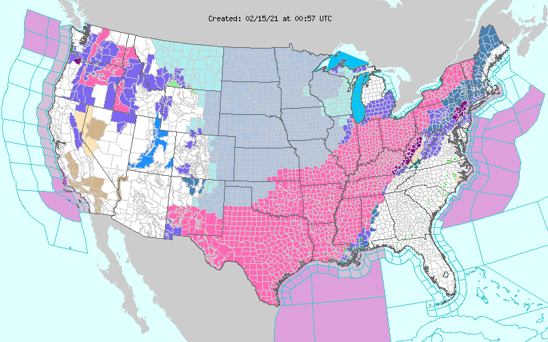
In advance of this system, winter storm warnings extended from New Mexico to Vermont, and wind chill warnings were in place across a significant portion of the Great Plains. Pictured below is the national warning/watch/advisory map as of 01z on February 15th (7pm CST on February 14th). Bright pink represents the winter storm warning, and gray represents the wind chill warnings.
In central Illinois, the first surge of snow moved in the afternoon on Sunday, February 14 and continued into the early morning hours on Monday, February 15. At that point, impacts were limited with light accumulations between 0.5" to 2.0". Early Monday afternoon, the second surge arrived and heavy snow fell through the rest of the day, ceasing around midnight. At times, snowfall rates of 2" per hour were reported. Across the NWS Lincoln county warning area, 2.0" to 9.5" of additional snow fell, with the greatest snow falling east of I-57 and south of I-70.
.gif)
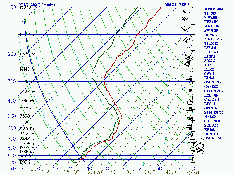
The anomalously cold air mass that was in place ahead of this system contributed to high snow-to-liquid ratios (between 20:1 and 25:1). The 00z February 16 sounding released from NWS Lincoln (video below) highlighted a deep dendritic growth zone (-12 to -18 degrees Celsius) extending from the surface to over 16,000 feet (~500mb). By the end of the event, numerous locations east of the Illinois River reported over 6" of storm total snowfall, with 8+" reports common south of I-70 and east of I-57. Drifts of up to 3' were reported in Sangamon and Vermilion County.
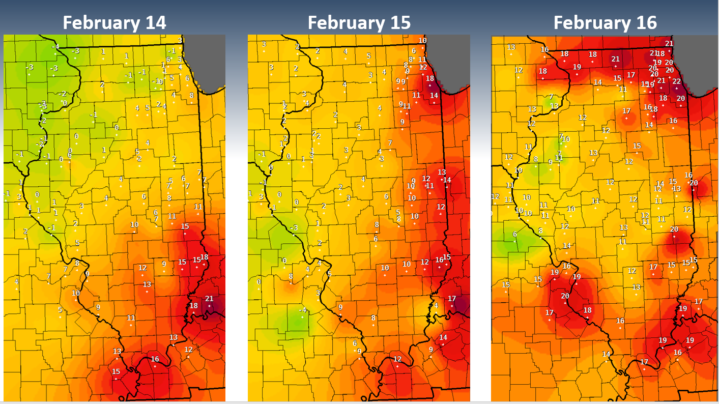
In addition to the significant snowfall, numerous coldest high temperature records were broken during the event (see the "Overview" tab for a complete list of records) and wind chills were well below zero for a prolonged period. High temperature were in the single digits across most of central Illinois on both February 14 and February 15, before climbing into the teens on February 16. Note that the temperature maps pictured below are considered preliminary. Certified climate information is available from the National Centers for Environmental Information or the Midwestern Regional Climate Center.
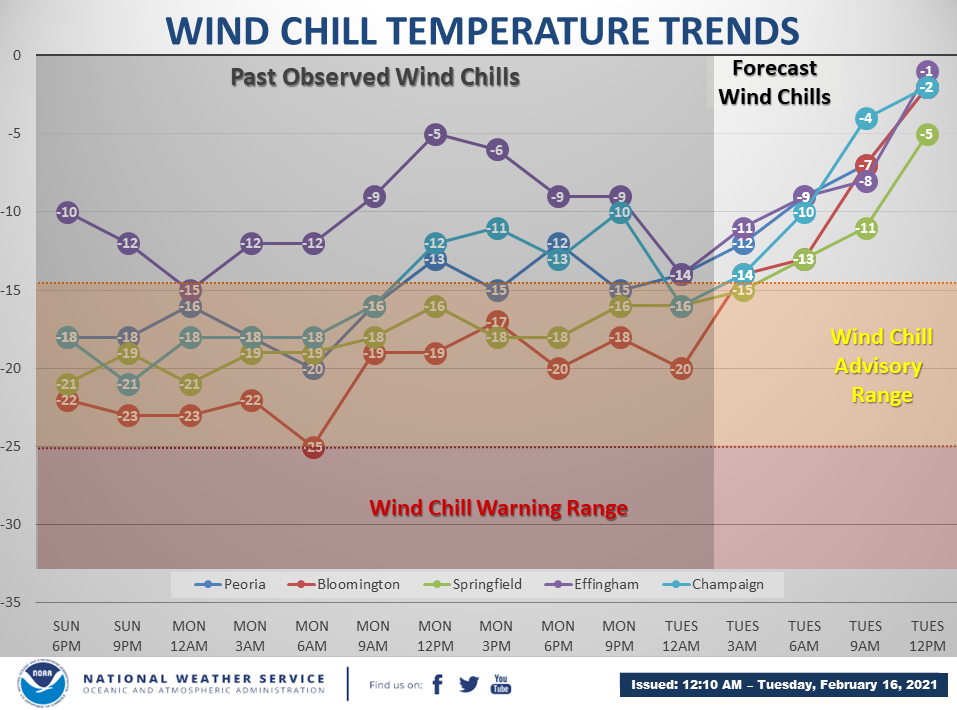
Here is how the observed wind chill values evolved at a few select locations across central Illinois through midnight on Tuesday, February 16.
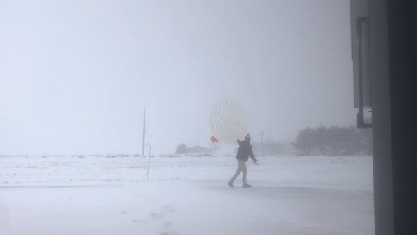
Photos from across the area during the event:


