Background Information
Near the end of each calendar year, ocean surface temperatures warm along the coasts of Ecuador and northern Peru. In the past, local residents referred to this annual warming as “El Nino,” meaning “The Child,” due to its appearance around the Christmas season. The appearance of El Nino signified the end of the fishing season and the arrival of the time for Peruvian fishermen to repair their nets and maintain their boats. Every two to seven years a much stronger warming appears along the west coast of South America, lasting for several months and often accompanied by heavy rainfall in the arid coastal regions of Ecuador and northern Peru. Over time the term El Nino began to be used in reference to these major warm episodes. During the 1960s, scientists began to link the abnormally warm waters along the west coast of South America with abnormally warm waters throughout the central and east-central equatorial Pacific. In addition, the warmer than average waters were shown to be closely related to a global atmospheric pressure oscillation known as the Southern Oscillation. The term El Nino refers to the coupled ocean-atmosphere phenomenon characterized by:

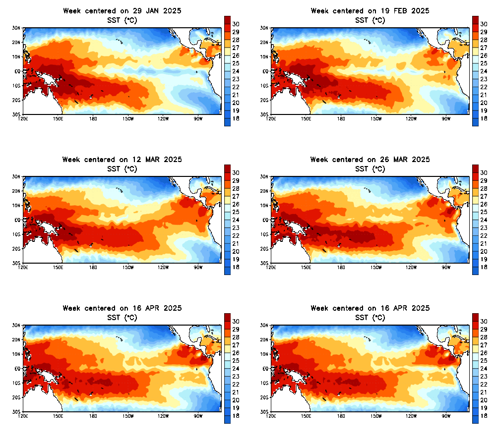
Latest sea surface temperatures over the eastern equatorial Pacific.
Other terms commonly used for the El Nino phenomenon include “Pacific warm episode” and “El Nino/ Southern Oscillation (ENSO) episode.” The El Nino phenomena and its counterpart, La Nina (where tropical Pacific water is cooler than normal) are the main sources of year-to-year variability in weather and climate for many areas of the world. El Nino and La Nina tend to alternate in an irregular cycle, which is often referred to as the ENSO cycle. El Nino episodes tend to:
There is considerable event-to-event variability in the timing, intensity and evolution of both El Nino and La Nina. Periods when neither El Nino nor La Nina is present are referred to as ENSO-neutral.
Why do we have ENSO?
What are the effects of El Nino on the United States? El Nino conditions influence wintertime atmospheric flow across the eastern North Pacific and North America. There is considerable event-to-event variability in the character of El Nino episodes, and in some areas impacts can vary substantially from one event to another. However, there are some sections of the United States where impacts are fairly consistent and predictable, especially when associated with strong El Nino episodes. In general, El Nino results in:
Current and Forecast Status of El Nino
As shown in the graph below, multi-model averages indicate that SSTs will remain well above normal through winter.
How Will El Nino Impact Central & Southeast Illinois?
It is important to note that the atmosphere is complex, and numerous patterns, oscillations, and systems interact to produce the weather over a given period of time in the Midwest. Impacts of El Nino vary with each episode, due to the overlaid effects of other climate patterns, persistent weather features, location of the strongest SST anomalies, and individual weather patterns themselves. Having a strong event can make the impacts stronger, but there can still be variance. Because the sample size of strong El Nino events is very small, it is not relevant to draw conclusions or base assumptions on strong events alone.
To get an idea of typical El Nino impacts on the local area, we look to the climate database to see what trends have been observed in past El Nino winters, compared to La Nina or ENSO-neutral winters. This comparison is depicted in the box and whiskers plots below, for Climate Division #24, which covers much of central and eastern Illinois. The box and whiskers plot is a way to show the range of percentiles that precipitation (left image) and temperature (right image) fall for the 3 different ENSO categories. The data are from 1950-2010. For a description of how to read the box and whiskers plot, click here.
As we can see from the plots, winter precipitation during El Nino events tends to be slightly lower than ENSO-neutral or La Nina. Temperatures are more variable for El Nino than ENSO-neutral or La Nina, with no significant change in median value. These are the conclusions we can have confidence in, based on the historical record.
Below are the current temperature and precipitation outlooks for winter 2015-16 from the Climate Prediction Center. This does not provide information about snowfall. Snowfall is highly dependent on individual storms, which are only forecast days in advance. The current forecast shows higher probabilities for above normal temperatures for most of central and southeast Illinois, and higher probabilities for below normal precipitation. These outlooks are updated once a month, near the 20th.
For more information on El Nino, see the Climate Prediction Center's ENSO webpage:
https://www.cpc.ncep.noaa.gov/products/precip/CWlink/MJO/enso.shtml