National Weather Service United States Department of Commerce

December Precipitation Highlights:
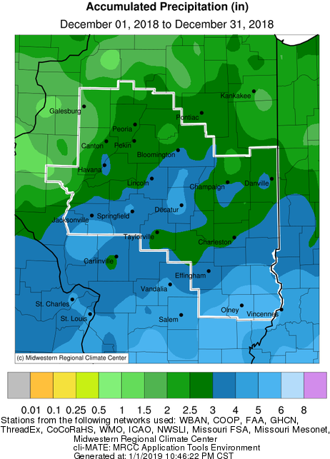
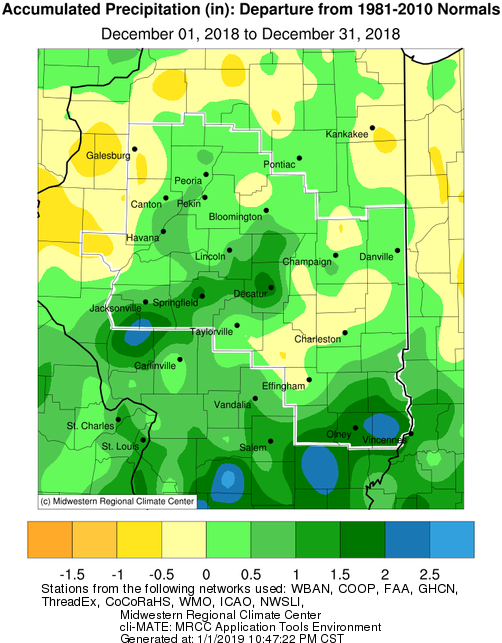
  • Precipitation was well above normal in most of central and southeast IL this month.  A few areas in east central and far west central IL saw slightly below normal precipitation.  For the remainder of the area, totals were generally a half inch to 1.5" above normal.
     
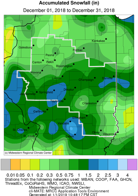
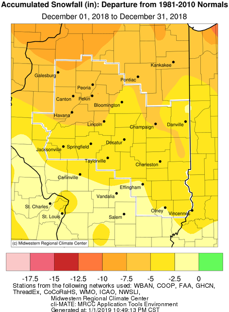
  • Snowfall was well below normal.  Most of the area received less than one inch of snow for the entire month, though areas near the I-72 corridor saw close to 2 inches.  These amounts were 2 to 7 inches below normal.  Galesburg only received a trace of snow, which tied a record for their lowest December snow total.
     
  • The most significant weather event of the month occurred on the 1st, when a tornado outbreak struck the area during the late afternoon and evening.  29 tornadoes touched down across the state, which was the largest Illinois December outbreak since 1957.  A summary of the event is available.  Other notable events occurred on the 14th-15th when heavy rain fell over southeast IL, and on the 31st when heavy rain affected much of the area, centered on the I-72 corridor.  The only minor snowfall event was on the 6th, when a few areas received an inch or two of snow.


December Temperature Highlights:

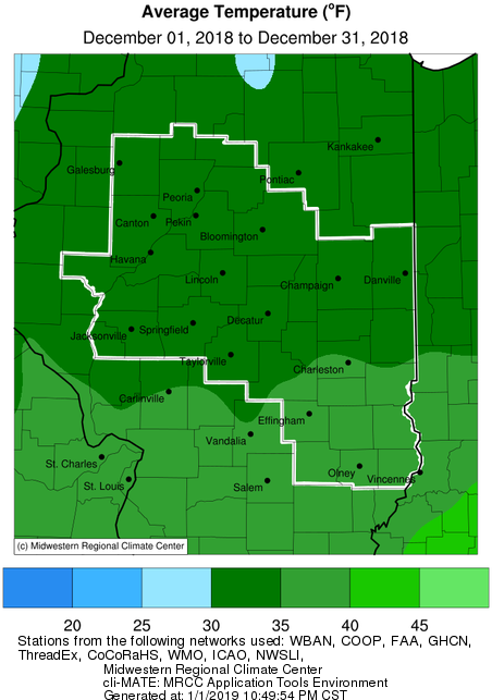
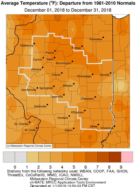
  • Monthly average temperatures were well above normal.  Much of the region saw readings at 4-5 degrees above normal.  Arctic air remained well north of the area through the month.  The coldest stretch of the month occurred on the 4th-10th, when readings were several degrees below normal for a week.  Even during this time, temperatures remained above zero.  Besides this time period, highs in the 40s and 50s were common.


Climate Statistics:
 

Site

Precipitation
 

Departure from Normal Snowfall

Departure
from
Normal

Average Temperature
 
Departure from Normal

Charleston

3.66" +0.51" 0.7" -1.9" 38.1 +6.0
Danville

4.09"

+1.26" 0.5" -4.7" 35.0 +4.2
Decatur

4.76"

+1.98" 1.1" -3.8" 34.9 +3.7
Effingham

2.80"

-0.42" 1.2" -2.0" 36.1 +4.5

Flora

5.27" +1.83" T -2.1" 37.3 +4.8
Galesburg

1.98"

-0.29" T -5.9" 30.4 +4.4

Havana

2.61" -0.15" 0.5" -7.4" N/A N/A

Jacksonville

3.40" +0.66" 1.0" -4.2" 33.3 +2.9
Lincoln 4.48" +1.84" 1.2" -5.0" 33.9 +4.4

Normal

2.70"

+0.01" 0.5" -4.6" 32.9 +5.1

Olney

5.63" +1.75" 0.5" -2.4" 37.7 +5.0

Paris

3.10" +0.07" 0.1" -5.4" 33.4 +3.2
Peoria

3.19"

+0.77" 0.4" -6.7" 34.0 +5.4
Springfield

4.91"

+2.39" 1.8" -3.8" 34.7 +4.3

Tuscola

2.86" -0.08" 1.0" -3.7" 33.6 +4.2
Urbana

3.37"

+0.64" 1.6" -5.0" 34.1 +5.2


The following links are the monthly and seasonal climate summaries for area cities. Only the summaries for Peoria, Springfield, and Lincoln are considered "official", meaning they are the station of record for their respective locations. The other summaries are "supplemental", meaning another location in the area is the official climate station for the city.

  • Peoria -- Peoria International Airport
  • Springfield -- Abraham Lincoln Capital Airport
  • Lincoln -- NWS Office
  • Champaign -- University of Illinois-Willard Airport
  • Decatur -- Decatur Airport
  • Lawrenceville -- Lawrenceville-Vincennes International Airport
  • Mattoon -- Coles County Memorial Airport

Climate data for other cities is available at http://w2.weather.gov/climate/xmacis.php?wfo=ilx