National Weather Service United States Department of Commerce

Autumn (September through November) Precipitation Highlights:

  • Autumn produced above normal precipitation across much of central Illinois, and near to slightly below normal precipitation for east central Illinois.  The much above normal precipitation that focused over northern sections of central Illinois, was the result of near record wet conditions in September, and well above normal rainfall in October.  The heaviest totals occurred from near Peoria north, where 15"+ of liquid-equivalent precipitation fell.  Surpluses in this area were as high as 7" in some locations.  Seasonal deficits of around an inch or less were common over east central Illinois.
     
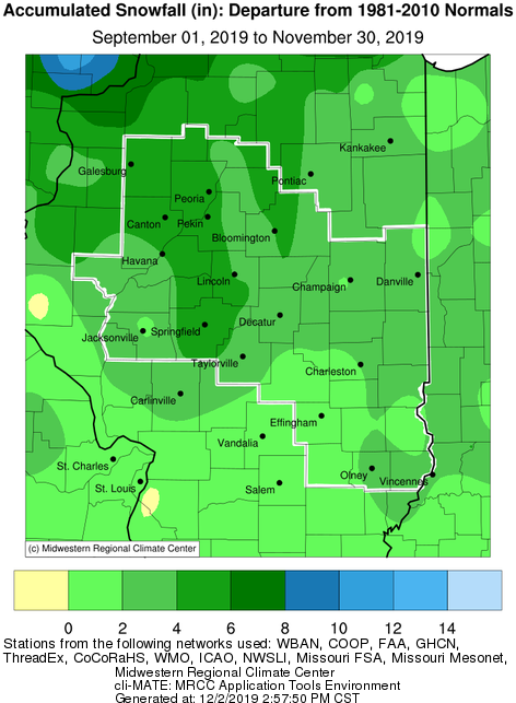
  • Snowfall was well above normal across the entire area.  This was due to to a couple periods of active early winter-like weather from the end of October through Veteran's Day.  Record daily snowfall occurred in some areas on Halloween and again on Veteran's Day.  Seasonal totals of 4-8" were common west of I-55, which was 4-6" above normal.


Autumn Temperature Highlights:

  • While Autumn ended up very near the 30-year average on temperatures, there were strong temperature swings during the 3-month period.  Fall started off exceptionally warm with September's average temperature more typical of August temperatures, or in the Top 10 warmest for many sites.  Record warmth started of the first few days of October, followed by seasonably cold conditions for much of the month.  An early winter-like airmass descended on the area for the last few days of the month and continued into mid-November.  This resulted in well below normal temperatures for November.


Autumn Climate Statistics:
 

City

Precipitation
 

Departure from Normal Snowfall

Departure
from
Normal

Average Temperature
 
Departure from Normal

Charleston

7.97" -3.00" 3.9" +3.2" 55.5 -0.7
Danville

11.25"

+0.92" 1.5" +1.2" 54.3 -0.7

Decatur

12.20" +2.10" 5.5" +5.3" 51.4 -0.5

Effingham

10.61" -0.10" 1.8" +1.4" 55.8 +0.3

Flora

14.48" +3.54" 3.0" +2.7" 56.3 +0.3

Galesburg

16.29" +7.20" 4.0" +3.2" 50.9 -1.2

Havana

11.11" +1.68" 3.0" +2.2" N/A N/A

Jacksonville

8.75" -1.40" 1.2" +0.7" 54.7 +0.6

Lincoln

11.17" +1.63" 4.5" +3.9" 53.5 -0.4

Normal

11.75"

+2.06" 5.7" +5.3" 52.7 -0.2

Olney

11.07" -0.47" 3.1" +2.8" 55.8 -0.4

Paris

9.41" -0.93" 3.0" +2.5" 53.5 -1.2

Peoria

14.85" +5.73" 6.0" +4.9" 53.6 -0.3
Springfield

13.94"

+4.68 7.0" +6.4" 54.6 -0.4

Taylorville

10.39" -0.62" 1.9" N/A N/A N/A

Tuscola

9.99" -0.12" 4.0" +3.3" 53.9 -0.3

Urbana

10.27" +0.20 2.1" +1.1" 53.9 +0.1


Links below are the seasonal climate summaries for area cities. Only the summaries for Peoria, Springfield and Lincoln are considered "official", meaning they are the station of record for their respective locations. The other summaries are "supplemental", meaning another location in the area is the official climate station for that city.

  • Peoria -- Peoria International Airport
  • Springfield -- Abraham Lincoln Capital Airport
  • Lincoln -- Lincoln NWS office
  • Champaign -- University of Illinois - Willard Airport
  • Decatur -- Decatur Airport
  • Lawrenceville -- Lawrenceville-Vincennes International Airport
  • Mattoon -- Coles County Airport

Climate data for other area cities is available at http://www.nws.noaa.gov/climate/xmacis.php?wfo=ilx 


Winter Look Ahead:
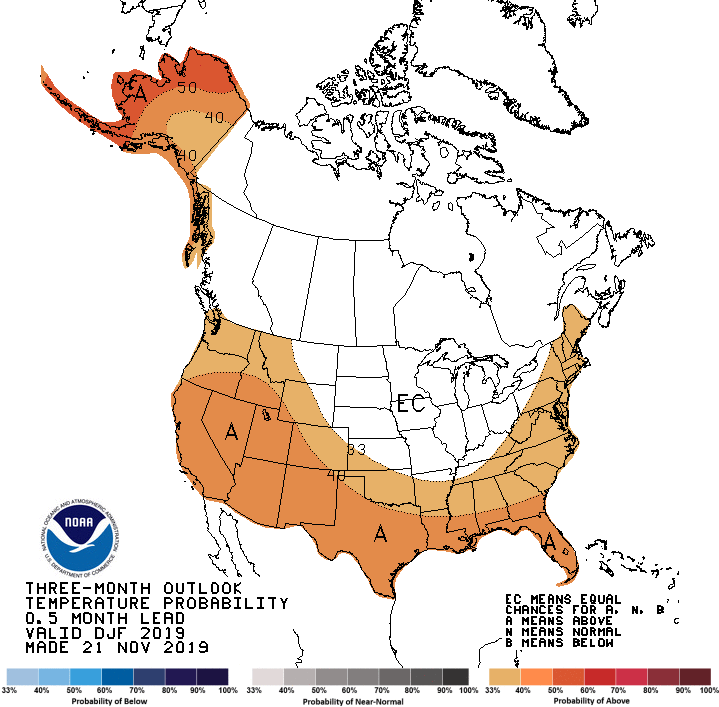
  • Official Winter outlooks from NOAA's Climate Predication center favor above normal precipitation, and no clear trend on temperatures for central and southeast IL.