April Precipitation Highlights:
- Precipitation was below to well below normal for much of the area. The largest deficits, which approached 3 inches, occurred over the western potions of the state. A single heavy rain event pushed areas of east central Illinois from Mattoon through Paris over 1 inch above normal.
- An area of low pressure deepened and tracked across the area on April 3rd. Several rounds of showers and thunderstorms accompanied this system. The hardest hit community was Charleston-Mattoon where numerous observers reported 3 to 4 inches of rain. In addition, some of the morning cells produced dime to quarter-sized hail. As the low tracked across central Illinois, a narrow line of storms developed along the trailing cold front during the afternoon of April 3rd. One of the cells embedded within the line produced a tornado across portions of Fayette and Effingham counties, while other cells brought gusty winds and pea-sized hail as the line swept across east-central Illinois.
- Snowfall was well above normal. Typical April snow totals are trace to a few tenths of an inch over central Illinois, while this month saw two late season events which totaled 4 to 7 inches over the central part of the state. This resulted in the 4th snowiest April in Springfield (4.8 inches) and 2nd snowiest April in Lincoln (7.1 inches).
- An upper-level disturbance tracking eastward out of the Central Plains brought a period of wet snow to portions of central Illinois on Sunday, April 1st. The axis of heaviest snowfall set up along a Rushville, to Lincoln, to Danville line where amounts of 3 to 5 inches were common. The highest total measured was 5.0 inches at both Astoria (Fulton County) and Browning (Schuyler County). Snowfall totals quickly decreased further north and south, with locations along and north of a Galesburg to Pontiac line and areas south of a St. Louis to Evansville line picking up no snow.
- A clipper system tracking from Montana into the southern Great Lakes brought a period of wet snow to central and southeast Illinois from the late afternoon of April 8th into the early morning of April 9th. The heaviest snow fell in a band from near Macomb southeastward to Lincoln and Decatur, where amounts of 2.5 to 3.5 inches were common. The highest snowfall measurement was 3.7 inches from an observer in Canton in Fulton County.
 |
 |
| April Precipitation |
April Precipitation Departure from Normal |
 |
 |
| April Snowfall |
April Snowfall Departure from Normal |
April Temperature Highlights:
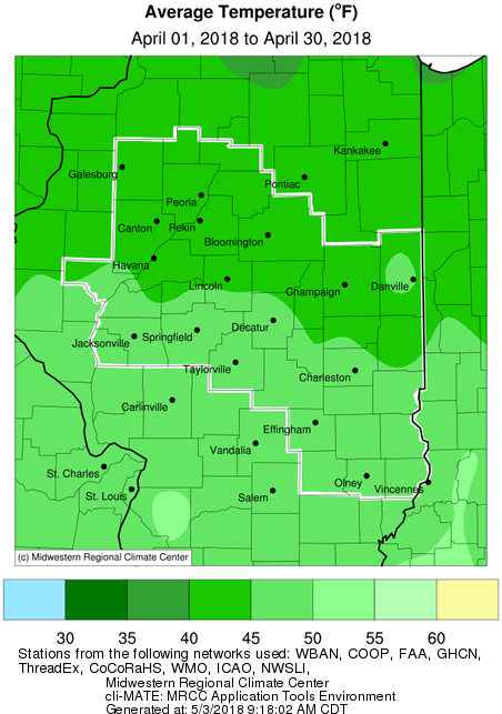
- An unusually cold weather pattern persisted through the first 10 days of April, when daily temperatures averaged 10-20 degrees below normal. After a brief warm-up, late season Arctic air again descended upon the region, with more double-digit below normal temperatures for the 15th-20th. The last 10 days of April saw fewer extremes, with daily readings a few degrees above or below normal. Overall, this resulted in monthly mean temperatures that were 6-9 degrees below normal, putting many sites in their top 10 coldest April.
- Peoria recorded its 6th coldest April. Record cold temperatures set on 6 days. Tied record April low temperature of 14 on the 2nd.
- Springfield recorded its 9th coldest April. Record cold temperatures set on 2 days. Set new monthly record low temperature of 16 on the 2nd.
- Lincoln recorded its 2nd coldest April. Record cold temperatures set on 5 days. Set new monthly record low temperature of -1 on the 2nd. This reading was also the latest sub-zero temperature ever recorded at Lincoln.
 |
 |
| April Mean Temperature |
April Temperature Departure from Normal |
Climate Data:
|
Site
|
Precipitation
|
Departure from Normal |
Snowfall |
Departure
from
Normal
|
Average Temperature
|
Departure from Normal |
|
Charleston
|
5.39" |
+1.10" |
3.2" |
+3.0" |
45.7 |
-9.0 |
| Danville |
3.04"
|
-0.94" |
2.9" |
+2.6" |
46.7 |
-6.8 |
| Decatur |
2.73"
|
-0.94" |
5.2" |
+5.0" |
46.3 |
-8.1 |
| Effingham |
3.03"
|
-0.98" |
3.6" |
+3.5" |
47.3 |
-6.1 |
|
Flora
|
3.02" |
-1.23" |
0 |
0 |
48.2 |
-6.7 |
| Galesburg |
0.72"
|
-3.0" |
2.8" |
+2.7" |
41.5 |
-9.4 |
|
Havana
|
2.03" |
-1.64" |
10.7" |
+10.6" |
NA |
NA |
|
Jacksonville
|
2.93" |
-1.00" |
3.8" |
+3.7" |
45.5 |
-8.2 |
| Lincoln |
2.51" |
-1.10" |
7.1" |
+6.8" |
44.3 |
-8.1 |
|
Normal
|
1.69"
|
-1.98" |
5.1" |
+4.4" |
41.3 |
-8.7 |
|
Olney
|
2.85" |
-1.48" |
0 |
0 |
47.3 |
-6.9 |
|
Paris
|
5.73" |
+1.62" |
3.2" |
+3.0" |
43.9 |
-8.8 |
| Peoria |
1.73"
|
-1.90" |
2.5" |
+1.9" |
45.1 |
-7.2 |
| Springfield |
2.18"
|
-1.33" |
4.8" |
+4.5" |
47.9 |
-5.6 |
|
Tuscola
|
2.74" |
-1.41" |
3.5" |
+3.4" |
44.8 |
-7.7 |
| Urbana |
2.32"
|
-1.36" |
4.9" |
+4.5" |
45.1 |
-6.8 |
The following links are the monthly and seasonal climate summaries for area cities. Only the summaries for Peoria, Springfield, and Lincoln are considered "official", meaning they are the station of record for their respective locations. The other summaries are "supplemental", meaning another location in the area is the official climate station for the city.
Climate data for other cities is available at http://w2.weather.gov/climate/xmacis.php?wfo=ilx

