April Precipitation Highlights:
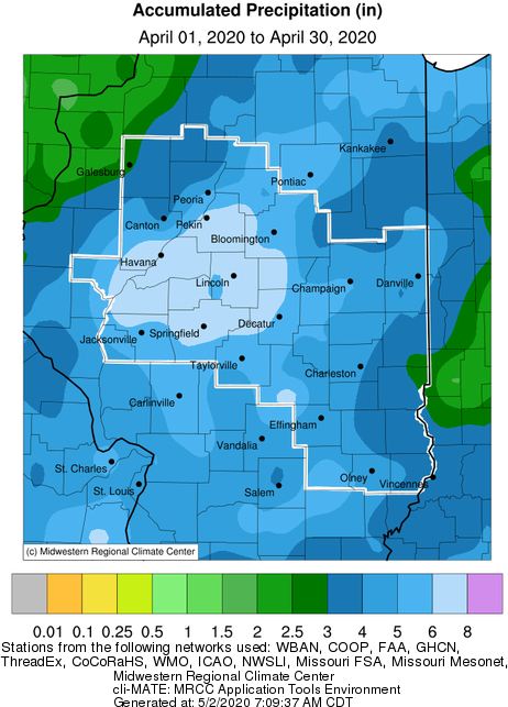
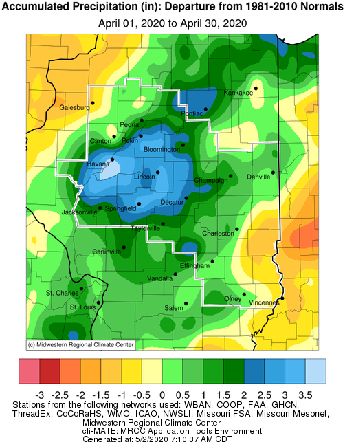
- Precipitation was well above normal for most of central Illinois. Areas from near the Illinois River Valley, to east of the I-55 corridor saw the highest totals. A couple heavy rain events late in the month pushed these areas 2-3" above normal. Much drier conditions were noted over northwest IL, and far eastern into southeast IL. These areas saw monthly totals 1-2" below normal.
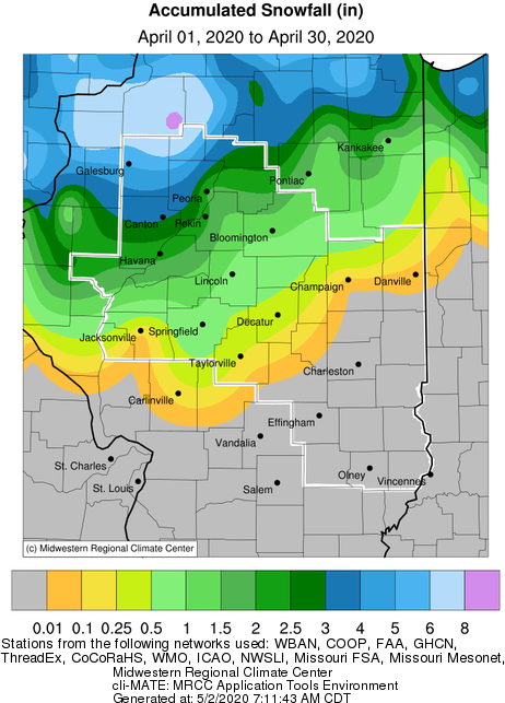
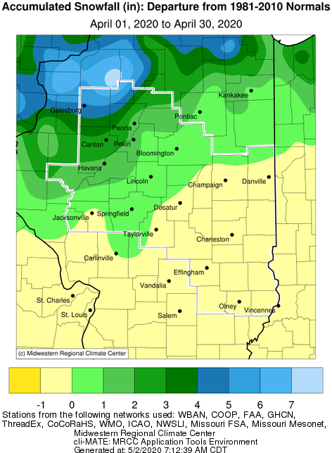
- A late season winter storm affected the area on April 16-17, resulting in accumulations as high as 6" near Galesburg. Amounts quickly dropped off to to south, with little to no accumulation south of the I-72 corridor. Since normal April snowfall is well below 1", this resulted in much above normal snow amounts over the northwest half of the area.
April Temperature Highlights:
- Monthly average temperatures were several degrees below normal across the entire area. Only one brief stretch of well above normal temperatures was noted on the 7th-8th, when highs reached the 80s for many locations. Otherwise most days were near to a few degrees below normal, with the exception of the 13th-18, which was well below normal. Several nights during this stretch saw sub-freezing temperatures, while highs were only in the 40s, around 20 degrees below normal.
Climate Statistics:
|
Site
|
Precipitation
|
Departure from Normal |
Snowfall |
Departure
from
Normal
|
Average Temperature
|
Departure from Normal |
|
Charleston
|
N/A |
|
N/A |
|
N/A |
|
| Danville |
2.98" |
-1.00" |
0 |
0 |
50.9 |
-2.6 |
| Decatur |
6.13" |
+2.46" |
0 |
0 |
50.1 |
-4.3 |
| Effingham |
4.11"
|
+0.10" |
0 |
0 |
51.2 |
-2.2 |
|
Flora
|
5.88" |
+1.63" |
0 |
0 |
51.6 |
-3.3 |
| Galesburg |
2.46"
|
-1.26" |
5.5" |
+5.4" |
46.9 |
-4.0 |
|
Havana
|
7.80" |
+4.13" |
0.5" |
+0.5" |
N/A |
N/A |
|
Jacksonville
|
5.34" |
+1.31" |
0 |
0 |
50.2 |
-1.9 |
|
Lincoln
|
7.20" |
+3.59" |
T |
-0.3" |
49.9 |
-2.5 |
|
Normal
|
4.97" |
+1.30" |
0.4" |
-0.3" |
48.0 |
-2.0 |
|
Olney
|
5.20" |
+0.87" |
0 |
0 |
50.3 |
-3.9 |
|
Paris
|
2.90" |
-1.21" |
0 |
-0.2 |
48.1 |
-4.6 |
|
Peoria
|
5.29" |
+1.66" |
2.9" |
+2.3" |
49.7 |
-2.6 |
| Springfield |
6.43"
|
+2.92" |
1.0" |
+0.7" |
51.0 |
-2.5 |
|
Tuscola
|
4.70" |
+0.55" |
T |
-0.1 |
48.8 |
-3.7 |
| Urbana |
5.59" |
+1.91" |
M |
M |
M |
M |
The following links are the monthly climate summaries for area cities. Only the summaries for Peoria, Springfield, and Lincoln are considered "official", meaning they are the station of record for their respective locations. The other summaries are "supplemental", meaning another location in the area is the official climate station for the city.
- Peoria -- Peoria International Airport
- Springfield -- Abraham Lincoln Capital Airport
- Lincoln -- National Weather Service Office
- Champaign -- University of Illinois-Willard Airport
- Decatur -- Decatur Airport
- Lawrenceville -- Lawrenceville-Vincennes International Airport
- Mattoon -- Coles County Memorial Airport
Climate data for other cities is available at http://w2.weather.gov/climate/xmacis.php?wfo=ilx
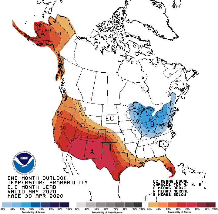
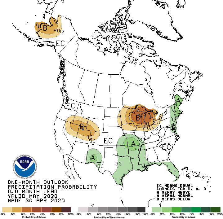
May Look Ahead:
- Official outlooks from NOAA's Climate Predication center show below normal temperatures favored for much of central and eastern IL, and a trend towards below normal rainfall for the northern third of the state.