Overview
|
A warm, humid and unstable air mass across Illinois on March 30, 2025 fueled multiple strong to severe storms during the afternoon. Several supercells developed as produced large hail up to 1.5 inches and damaging winds as high as 85 mph. Bowing segments produced wind damage across mainly the eastern half of central Illinois. One tornado was surveyed in southern Champaign County. It produced EF-1 damage with 90 mph winds. |
Tornadoes
Select a tornado from the table to zoom into the track and view more information. The default table view is limited to 8 tracks, but can be scrolled by a mouse wheel or dynamically expanded. Additionally, the table can fill the entire window by clicking the small circular expanding arrow icon at the very top right of the table and returned to its original size by clicking the button again. The side information panel that opens over the map can be closed using the "X" on the upper right corner of the pop-up. Zoom into the map and click damage points to see detailed information and pictures from the surveys.
|
NOTE: times shown below are local to your device's time zone. |

The Enhanced Fujita (EF) Scale classifies tornadoes into the following categories:
| EF0 Weak 65-85 mph |
EF1 Moderate 86-110 mph |
EF2 Significant 111-135 mph |
EF3 Severe 136-165 mph |
EF4 Extreme 166-200 mph |
EF5 Catastrophic 200+ mph |
 |
|||||
| Tornadoes that fail to impact any ratable structures on the EF-Scale are rated EF-Unknown (EF-U) | |||||
Wind & Hail
Add a written summary or simply an LSR map in this section. If writing an extensive report, you can break the report down into wind and hail below (otherwise delete).
Wind
Insert summary here.
| Caption | Caption | Caption | Caption |
Hail
Insert summary here.
| Caption | Caption | Caption | Caption |
Storm Reports
Preliminary Local Storm Report...Summary
National Weather Service Lincoln IL
541 PM CDT Mon Mar 31 2025

..TIME...   ...EVENT...      ...CITY LOCATION...     ...LAT.LON...
..DATE...   ....MAG....      ..COUNTY LOCATION..ST.. ...SOURCE....
            ..REMARKS..

0122 PM     Tornado          4 SSE Ivesdale          39.89N 88.43W
03/30/2025                   Champaign          IL   NWS Storm Survey

            The tornado moved from the SW corner of
            Champaign County to just north of Tolono. It
            covered 12 miles in 12 minutes doing EF1
            damage to outbuildings and trees. It was 200
            yds wide with a peak wind of 90 mph.

0140 PM     Tstm Wnd Dmg     2 SSE Urbana            40.08N 88.20W
03/30/2025                   Champaign          IL   Trained Spotter

            Several trees blown down on the south side
            of Windsor Road, between Meadow Brook Park
            and Philo Rd. Time estimated from radar.

0450 PM     Hail             Yale                    39.12N 88.02W
03/30/2025  M1.00 Inch       Jasper             IL   Cocorahs

            Time estimated from radar.

0105 PM     Tstm Wnd Gst     3 NW Kirksville         39.60N 88.71W
03/30/2025  M47 MPH          Moultrie           IL   Mesonet

            Mesonet station FW6864 Sullivan Station
            Elevation: 672 ft.

0107 PM     Tstm Wnd Dmg     Sullivan                39.60N 88.61W
03/30/2025                   Moultrie           IL   Broadcast Media

            Downs trees and power lines and poles in
            Sullivan via Facebook post.

0117 PM     Tstm Wnd Dmg     2 NW Mattoon            39.50N 88.40W
03/30/2025                   Coles              IL   Public

            Photos of power poles down northwest of
            Mattoon on near highway 33.

0129 PM     Tstm Wnd Gst     Coles County Airport    39.47N 88.27W
03/30/2025  M45 MPH          Coles              IL   ASOS

            ASOS station KMTO Coles Co. Mem AP Station
            Elevation: 685 ft.

0130 PM     Tstm Wnd Dmg     Tolono                  39.99N 88.26W
03/30/2025                   Champaign          IL   Emergency Mngr

            Building collapsed from high winds.

0130 PM     Tstm Wnd Gst     Tolono                  39.99N 88.26W
03/30/2025  M55 MPH          Champaign          IL   Emergency Mngr

            Pea size hail with 55 mph wind gust at
            Tolono.

0130 PM     Tstm Wnd Dmg     2 NNE Tolono            40.01N 88.25W
03/30/2025                   Champaign          IL   Emergency Mngr

            Morton Building collapsed at 1083 Caty Road
            900 N 1.5 miles NNE of Tolono. Photos sent.

0130 PM     Tstm Wnd Dmg     2 NNE Tolono            40.01N 88.25W
03/30/2025                   Champaign          IL   Emergency Mngr

            Storage unit damaged on county road 900 just
            east of highway 45 1.5 miles NNE of Tolono.

0135 PM     Tstm Wnd Dmg     3 W Charleston          39.48N 88.23W
03/30/2025                   Coles              IL   Emergency Mngr

            Several power poles and lines blown down
            west of 2.5 miles west of Charleston.

0135 PM     Tstm Wnd Dmg     Savoy                   40.06N 88.25W
03/30/2025                   Champaign          IL   Emergency Mngr

            Pine tree broke off from high winds and
            landed on a car.

0135 PM     Tstm Wnd Gst     Willard Airport         40.03N 88.28W
03/30/2025  M68 MPH          Champaign          IL   ASOS

            ASOS station KCMI Willard Arpt Station
            Elevation: 742 ft.

0135 PM     Tstm Wnd Dmg     4 SW Savoy              40.02N 88.31W
03/30/2025                   Champaign          IL   Mesonet

            3 car crashes on southbound I-57 at mile
            marker 229 from high winds.

0135 PM     Tstm Wnd Gst     Philo                   40.01N 88.16W
03/30/2025  M50 MPH          Champaign          IL   Emergency Mngr


0136 PM     Tstm Wnd Gst     Effingham               39.12N 88.54W
03/30/2025  M50 MPH          Effingham          IL   Mesonet

            Marble size hail with the 50 mph wind gust
            in Effingham.

0140 PM     Hail             Effingham               39.12N 88.54W
03/30/2025  M1.00 Inch       Effingham          IL   Mesonet


0140 PM     Tstm Wnd Gst     2 SSE Urbana            40.08N 88.19W
03/30/2025  M63 MPH          Champaign          IL   Mesonet

            Mesonet station FW0668 Urbana Station
            Elevation: 748 ft.

0141 PM     Tstm Wnd Gst     4 NW Longview           39.92N 88.11W
03/30/2025  M54 MPH          Champaign          IL   Mesonet

            Mesonet station UP773 4 NW Longview Station
            Elevation: 677 ft.

0145 PM     Tstm Wnd Dmg     Royal                   40.19N 87.97W
03/30/2025                   Champaign          IL   Emergency Mngr

            At least 8-9 power poles blown down near
            Royal.

0145 PM     Hail             Ashmore                 39.53N 88.02W
03/30/2025  M1.00 Inch       Coles              IL   Mesonet

            Photo sent with 1 inch hail next to a
            quarter. Hail lasted for about 15 minutes
            and ponding of water.

0145 PM     Tstm Wnd Dmg     Saint Joseph            40.11N 88.04W
03/30/2025                   Champaign          IL   Mesonet

            Semi truck on west bound I-74 blown over
            near St Joseph by high winds.

0145 PM     Tstm Wnd Gst     Sidney                  40.02N 88.07W
03/30/2025  E70 MPH          Champaign          IL   Emergency Mngr

            Some structural damage from high winds along
            with power outages.

0145 PM     Tstm Wnd Dmg     Sidney                  40.02N 88.07W
03/30/2025                   Champaign          IL   Emergency Mngr

            Morton building damaged by high winds.

0145 PM     Tstm Wnd Dmg     Saint Joseph            40.11N 88.04W
03/30/2025                   Champaign          IL   Emergency Mngr

            Power outages from high thunderstorm wind
            gusts.

0150 PM     Tstm Wnd Gst     Ogden                   40.11N 87.96W
03/30/2025  M62 MPH          Champaign          IL   CO-OP Observer


0150 PM     Tstm Wnd Dmg     Homer                   40.04N 87.96W
03/30/2025                   Champaign          IL   Emergency Mngr

            Power outages in Homer from high winds.

0200 PM     Rain             4 S Bondville           40.05N 88.37W
03/30/2025  M1.18 Inch       Champaign          IL   Mesonet

            Mesonet station BNDI2 UI BONDVILLE CHAMPAIGN
            9 SW IL US.

0200 PM     Tstm Wnd Dmg     7 NW Danville           40.21N 87.72W
03/30/2025                   Vermilion          IL   Amateur Radio

            House roof damage from strong winds on E
            2430 North road.

0200 PM     Hail             Ashmore                 39.53N 88.02W
03/30/2025  M0.75 Inch       Coles              IL   Trained Spotter

            Pea to dime size hail reported in Ashmore.

0200 PM     Flood            Oakland                 39.66N 88.03W
03/30/2025                   Coles              IL   Trained Spotter

            Over 6 inches of water flowing over road
            from Ashmore to Oakland.

0205 PM     Tstm Wnd Dmg     5 NNW Danville          40.21N 87.67W
03/30/2025                   Vermilion          IL   Emergency Mngr

            Tree blown down on a house near Denmark Rd
            and West Newell Rd.

0205 PM     Tstm Wnd Gst     2 WSW Hoopeston         40.45N 87.71W
03/30/2025  M85 MPH          Vermilion          IL   CO-OP Observer

            Measured wind gusts from 70 to 85 mph.
            Unofficial nearby report of 105 mph wind
            gust.

0207 PM     Tstm Wnd Dmg     Rossville               40.38N 87.66W
03/30/2025                   Vermilion          IL   Broadcast Media

            Video showing half of large tree blowing
            down in backyard.

0207 PM     Tstm Wnd Dmg     Hoopeston               40.47N 87.67W
03/30/2025                   Vermilion          IL   CO-OP Observer

            Tree branches blown down on power lines.
            About 25 percent of Hoopeston without power.

0207 PM     Tstm Wnd Gst     Rossville               40.38N 87.66W
03/30/2025  M70 MPH          Vermilion          IL   Emergency Mngr


0207 PM     Tstm Wnd Gst     3 W Bismarck            40.26N 87.67W
03/30/2025  M62 MPH          Vermilion          IL   Emergency Mngr

            Wind gust of 62 mph with damage to chicken
            coop fence. Wind snapped old cedar posts
            off.

0207 PM     Hail             Hoopeston               40.47N 87.67W
03/30/2025  M0.75 Inch       Vermilion          IL   CO-OP Observer

            Dime size hail in Hoopeston.

0207 PM     Tstm Wnd Dmg     Hoopeston               40.47N 87.67W
03/30/2025                   Vermilion          IL   Public

            Video on Facebook showing tree falling down
            on a house in Hoopeston from strong winds.

0208 PM     Tstm Wnd Dmg     Bismarck                40.26N 87.61W
03/30/2025                   Vermilion          IL   Public

            Damage Shed from strong winds in Bismarck.
            Facebook report.

0209 PM     Tstm Wnd Gst     1 NNW Hoopeston         40.48N 87.68W
03/30/2025  M70 MPH          Vermilion          IL   Emergency Mngr

            70 mph winds at route 1 near the Iroquois
            and Vermilion county border with nickel
            hail.

0209 PM     Hail             Hoopeston               40.47N 87.67W
03/30/2025  M0.88 Inch       Vermilion          IL   Emergency Mngr

            Nickel hail and 70 mph winds along route 1
            near Iroquois and Vermilion county line.

0210 PM     Tstm Wnd Dmg     Danville                40.14N 87.63W
03/30/2025                   Vermilion          IL   Emergency Mngr

            Garage destroyed in Danville near Fairchild
            and Griffin streets.

0210 PM     Tstm Wnd Dmg     Danville                40.14N 87.63W
03/30/2025                   Vermilion          IL   Emergency Mngr

            Trees and powerlines blown down.

0210 PM     Tstm Wnd Dmg     Vermilion Regional Airp 40.20N 87.60W
03/30/2025                   Vermilion          IL   Public

            Damge to out building 0.5 mile NE of
            Vermilion Regional Airport at 2400 North Rd
            and 1950 East Rd. Photo provided.

0215 PM     Tstm Wnd Dmg     6 E Hoopeston           40.47N 87.56W
03/30/2025                   Vermilion          IL   Public

            Indiana sign along route 9 near the Indiana
            border damaged along with a farm shed.

0215 PM     Tstm Wnd Gst     Edgar County Airport    39.70N 87.67W
03/30/2025  M49 MPH          Edgar              IL   AWOS

            AWOS station KPRG Edgar Co. Arpt.

0229 PM     Flood            Kansas                  39.55N 87.94W
03/30/2025                   Edgar              IL   Mesonet

            Standing water at Kansas Fire Protection
            District E. Hefner parking lot.

0245 PM     Tstm Wnd Dmg     Westfield               39.46N 88.00W
03/30/2025                   Clark              IL   Mesonet

            9 power poles broken and blown down.

0325 PM     Hail             3 WSW Flora             38.65N 88.54W
03/30/2025  M0.88 Inch       Clay               IL   Emergency Mngr

            Nickel hail between Xenia and Flora on old
            route 50.

0332 PM     Hail             10 SE Paris             39.51N 87.56W
03/30/2025  M0.75 Inch       Edgar              IL   Broadcast Media

            Pea to Dime size hail 10 miles southeast of
            Paris.

0335 PM     Hail             Flora                   38.67N 88.49W
03/30/2025  M1.00 Inch       Clay               IL   Public

            Photo from Facebook of large hail in Flora.

0344 PM     Non-Tstm Wnd Gst 1 WSW Decatur Airport   39.83N 88.87W
03/30/2025  M46 MPH          Macon              IL   ASOS

            ASOS station KDEC Decatur Arpt.

0345 PM     Hail             Clay City               38.69N 88.35W
03/30/2025  M1.00 Inch       Clay               IL   Mesonet


0355 PM     Tstm Wnd Dmg     2 N Olney               38.76N 88.09W
03/30/2025                   Richland           IL   Emergency Mngr

            Tree blown down along with pea size hail.

0400 PM     Tstm Wnd Gst     3 SW Dundas             38.80N 88.12W
03/30/2025  M49 MPH          Richland           IL   Mesonet

            Mesonet station FW1422 Olney Station
            Elevation: 534 ft.

0403 PM     Hail             1 S Flora               38.65N 88.49W
03/30/2025  M1.50 Inch       Clay               IL   Mesonet

            Ping pong size hail south of Flora with
            photos.

0405 PM     Hail             3 E Dundas              38.82N 88.04W
03/30/2025  E1.00 Inch       Richland           IL   Public


0420 PM     Tstm Wnd Dmg     Robinson                39.01N 87.74W
03/30/2025                   Crawford           IL   Emergency Mngr

            A few powerlines blown down in Robinson
            along with pea size hail.

0427 PM     Hail             3 E Dundas              38.82N 88.04W
03/30/2025  E0.88 Inch       Richland           IL   Public


0435 PM     Tstm Wnd Gst     Effingham County Airpor 39.07N 88.53W
03/30/2025  M55 MPH          Effingham          IL   AWOS

            AWOS station K1H2 Effingham Arpt.

0451 PM     Tstm Wnd Gst     Lawrenceville Airport   38.76N 87.60W
03/30/2025  M63 MPH          Lawrence           IL   ASOS

            ASOS station KLWV Lawrenceville AP Station
            Elevation: 430 ft.

0455 PM     Tstm Wnd Gst     Mount Carmel Airport    38.61N 87.73W
03/30/2025  M49 MPH          Lawrence           IL   AWOS

            AWOS station KAJG Mt Carmel Arpt Station
            Elevation: 425 ft.

0501 PM     Hail             3 N Vincennes Universit 38.73N 87.52W
03/30/2025  E0.75 Inch       Lawrence           IL   Public

            Report from mPING: Dime (0.75 in.).
Photos & Video
Header
 |
 |
 |
 |
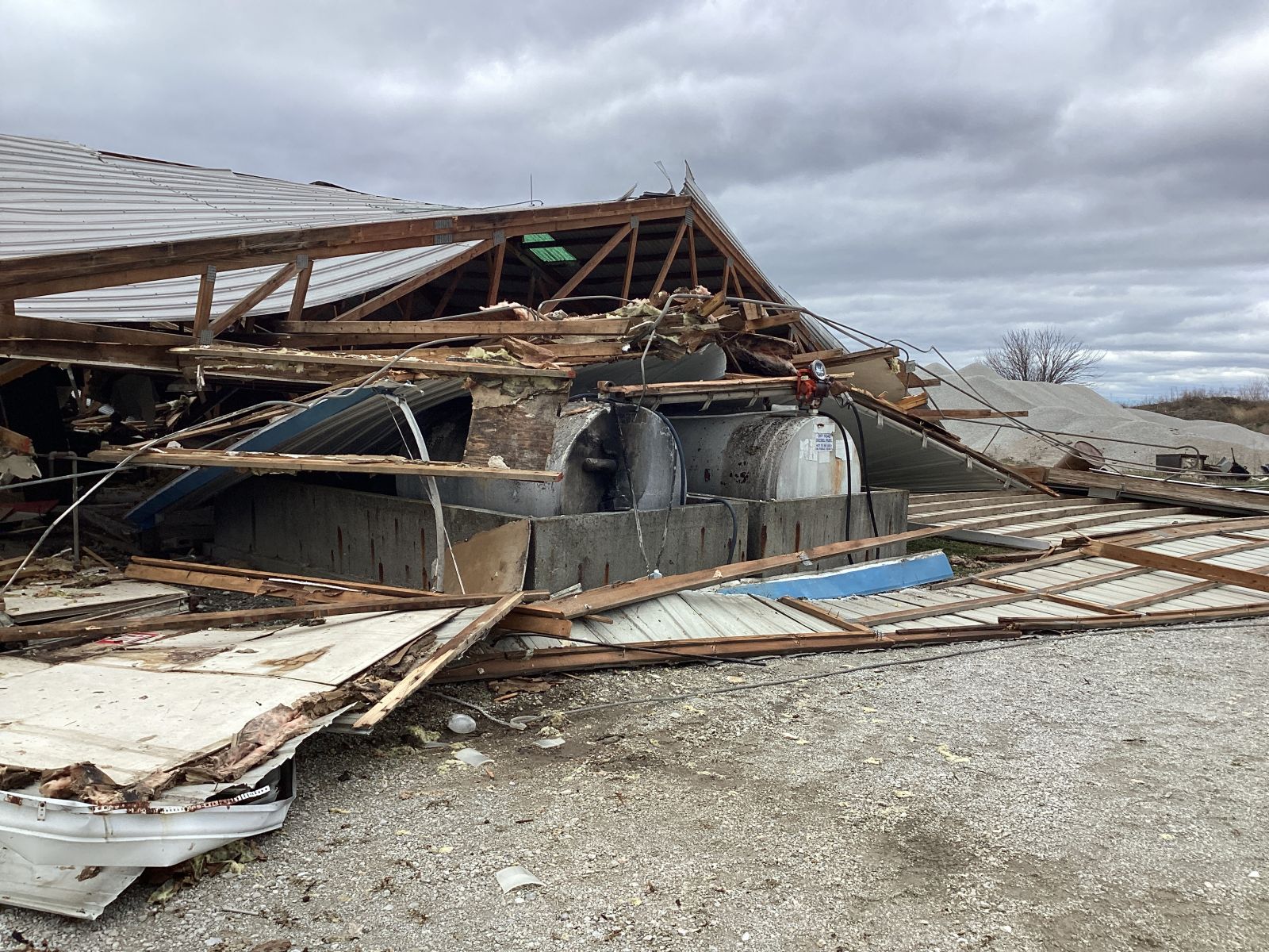
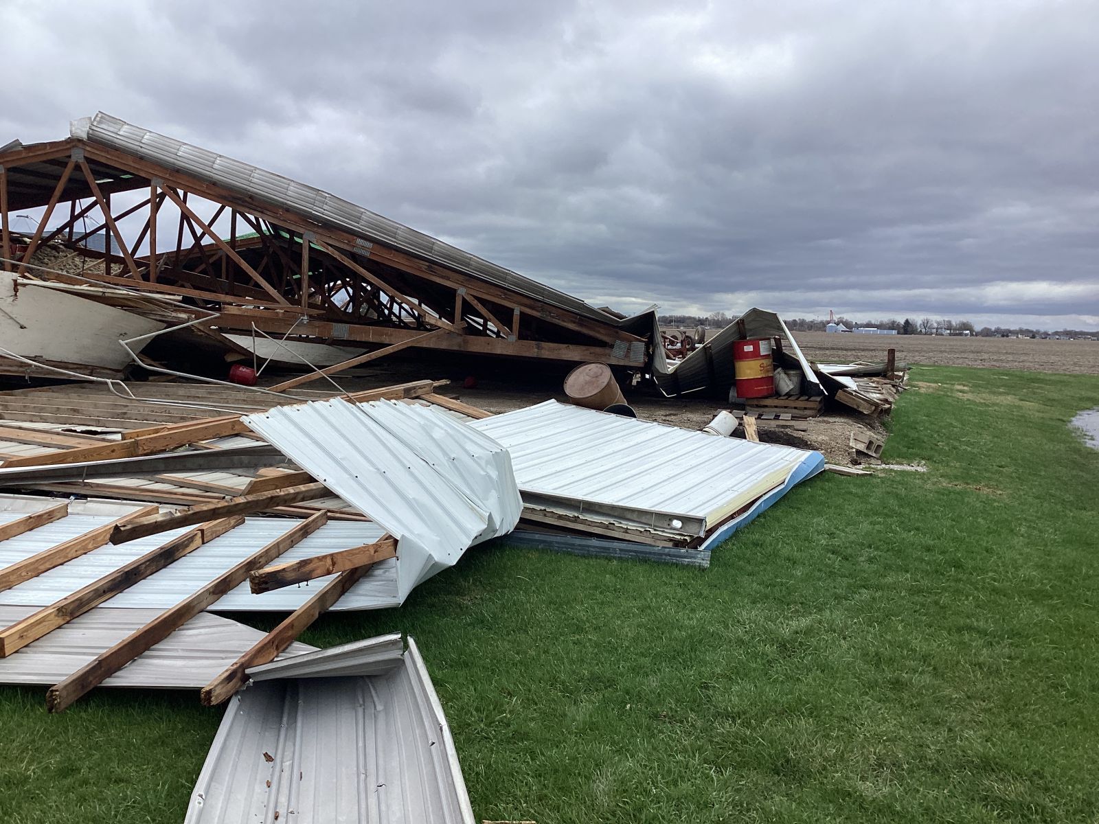
| Tolono Warehouse (NWS Damage Survey) |
Tolono Warehouse (NWS Damage Survey) |
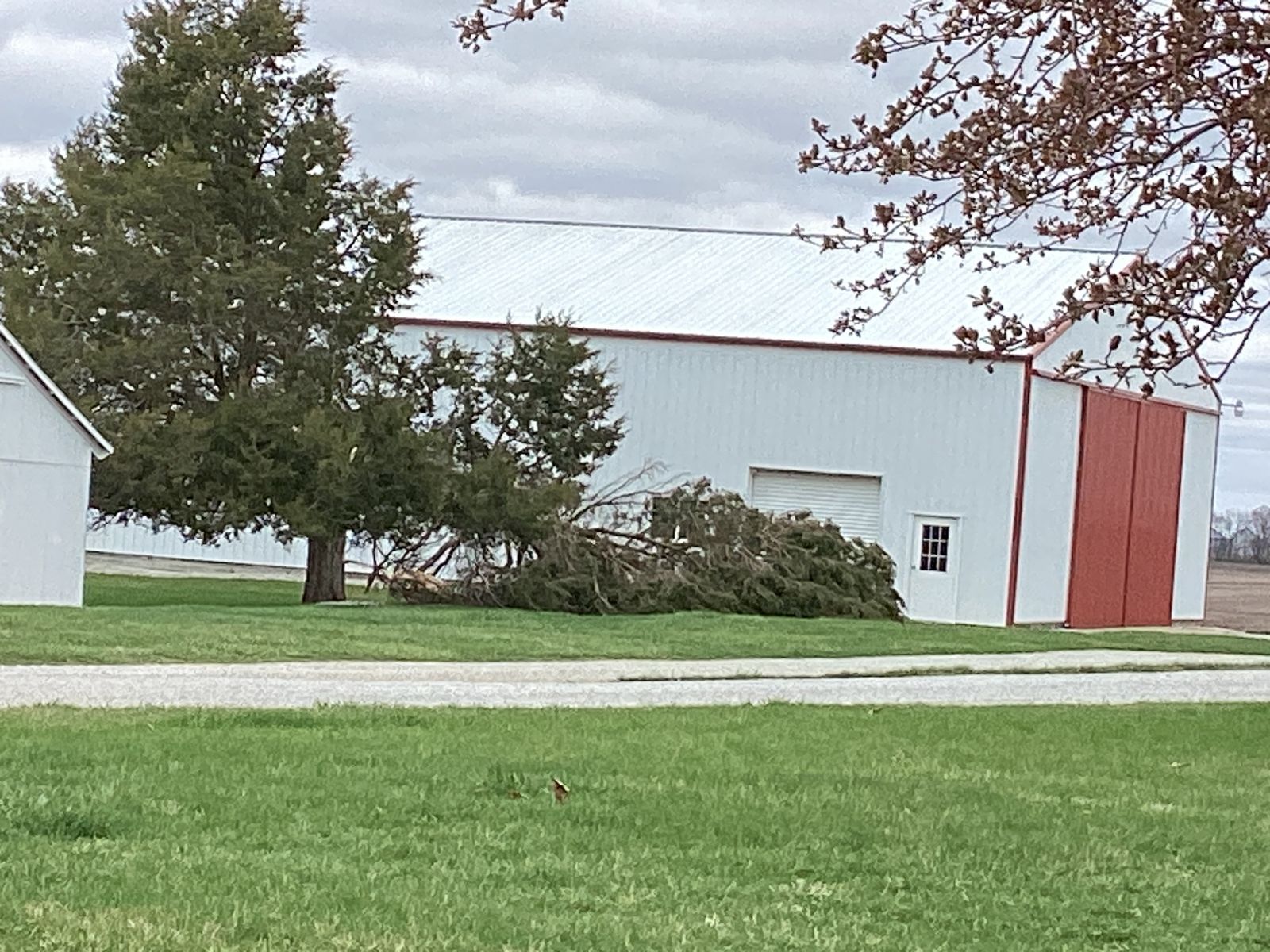
Tree snapped off - SW of Tolono (NWS Damage Survey) |
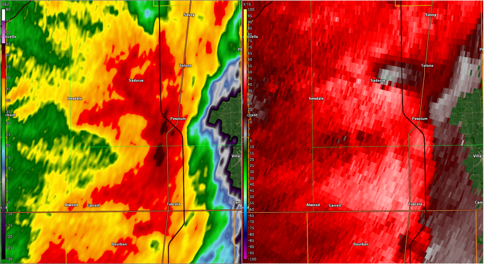
Radar near Tolono (NWS) |
 |
Media use of NWS Web News Stories is encouraged! Please acknowledge the NWS as the source of any news information accessed from this site. |
|

