Overview
|
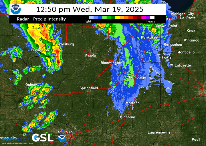
Clusters of thunderstorms formed ahead of a cold front during mid to late afternoon, producing several gustnadoes and a few weak tornadoes. Many storms produced small hail and a few produced large hail over 1" in diameter. Additional storms developed along a dry line during the evening and produces sporadic severe wind gusts and small hail. |
|
Tornadoes
Select a tornado from the table to zoom into the track and view more information. The default table view is limited to 8 tracks, but can be scrolled by a mouse wheel or dynamically expanded. Additionally, the table can fill the entire window by clicking the small circular expanding arrow icon at the very top right of the table and returned to its original size by clicking the button again. The side information panel that opens over the map can be closed using the "X" on the upper right corner of the pop-up. Zoom into the map and click damage points to see detailed information and pictures from the surveys.
|
NOTE: times shown below are local to your device's time zone. |

The Enhanced Fujita (EF) Scale classifies tornadoes into the following categories:
| EF0 Weak 65-85 mph |
EF1 Moderate 86-110 mph |
EF2 Significant 111-135 mph |
EF3 Severe 136-165 mph |
EF4 Extreme 166-200 mph |
EF5 Catastrophic 200+ mph |
 |
|||||
| Tornadoes that fail to impact any ratable structures on the EF-Scale are rated EF-Unknown (EF-U) | |||||
Storm Reports
Preliminary Local Storm Report...Summary
National Weather Service Lincoln IL
1243 AM CDT Fri Mar 21 2025
..TIME... ...EVENT... ...CITY LOCATION... ...LAT.LON...
..DATE... ....MAG.... ..COUNTY LOCATION..ST.. ...SOURCE....
..REMARKS..
0200 PM Tstm Wnd Dmg 2 ENE Lewistown 40.40N 90.12W
03/19/2025 Fulton IL Public
Portion of barn roof removed, shingles on
home blown off, and section of a large tree
fell. Relayed be county EMA. Time estimated
from radar.
0249 PM Tornado 3 ESE Banner 40.50N 89.85W
03/19/2025 Tazewell IL Broadcast Media
A broadcast meteorologist video taped the
EFU tornado touching down 3 miles ESE of
Banner, just east of the Illinois River. The
tornado moved northeast through grassy areas
without creating any visible damage. It
dissipated after about 1 minute.
0325 PM Tstm Wnd Dmg 3 NW Delavan 40.40N 89.59W
03/19/2025 Tazewell IL Emergency Mngr
Power pole bent and 12 inch tree snapped 2.5
miles NW of Delavan.
0340 PM Tstm Wnd Dmg 2 E Pleasant Plains 39.87N 89.88W
03/19/2025 Sangamon IL Emergency Mngr
Three power poles blown down on Horse Barn
Road. Ameren notified.
0345 PM Tstm Wnd Dmg 1 SE Auburn 39.58N 89.73W
03/19/2025 Sangamon IL Emergency Mngr
Power poles blown down. Ameren notified.
0348 PM Tstm Wnd Dmg 2 SW Mackinaw 40.51N 89.37W
03/19/2025 Tazewell IL Public
A large oak tree was snapped.
0400 PM Tstm Wnd Gst Goodfield 40.63N 89.28W
03/19/2025 M70 MPH Woodford IL Trained Spotter
Estimated wind gust along with dime size
hail.
0405 PM Tstm Wnd Dmg 2 S Allenville 39.53N 88.53W
03/19/2025 Moultrie IL Trained Spotter
Some damage to outbuildings from strong
thunderstorm wind gusts. Photos provided.
0405 PM Tstm Wnd Gst 5 SE Sullivan 39.55N 88.54W
03/19/2025 M73 MPH Moultrie IL Trained Spotter
0410 PM Hail 3 NNE Lakewood 39.36N 88.87W
03/19/2025 M1.00 Inch Shelby IL Public
0410 PM Tstm Wnd Dmg 2 N Hudson 40.64N 88.99W
03/19/2025 McLean IL Emergency Mngr
Semi-truck overturned by high winds at mile
marker 7 on I-39 in median. Driver
transported to hospital.
0419 PM Tstm Wnd Dmg Allenville 39.55N 88.53W
03/19/2025 Moultrie IL NWS Storm Survey
Large tree branch broken. Time estimated
from radar.
0430 PM Tstm Wnd Dmg 3 NW Cooks Mill 39.61N 88.45W
03/19/2025 Coles IL Emergency Mngr
Power pole blown down.
0430 PM Tstm Wnd Dmg Beason 40.15N 89.19W
03/19/2025 Logan IL Public
A power pole was snapped and leaning over,
resulting in a detour on State Route 10 near
Beason.
0430 PM Tstm Wnd Dmg Chenoa 40.74N 88.72W
03/19/2025 McLean IL Emergency Mngr
Power outages from strong winds and small
hail.
0440 PM Tstm Wnd Dmg 3 NE Kenney 40.12N 89.05W
03/19/2025 De Witt IL Public
Tree branches were blown down onto Highway
54.
0440 PM Tstm Wnd Dmg 3 N Mattoon 39.52N 88.37W
03/19/2025 Coles IL NWS Storm Survey
Partial roof loss on farm outbuilding. Time
estimated from radar.
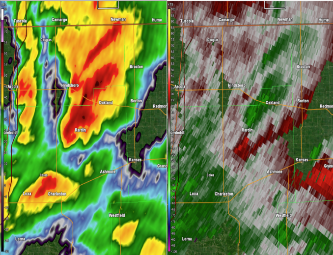
0445 PM Tstm Wnd Dmg 3 SW Rardin 39.57N 88.14W
03/19/2025 Coles IL NWS Storm Survey
Gutter torn off building and large branches
broken.
0445 PM Tstm Wnd Dmg 3 WSW Rardin 39.59N 88.16W
03/19/2025 Coles IL NWS Storm Survey
Corrects previous tstm wnd dmg report from 3
WSW Rardin. Large tree branches broken. Time
estimated from radar.
0445 PM Tstm Wnd Dmg 4 E Fisher 40.32N 88.27W
03/19/2025 Champaign IL Emergency Mngr
Power pole down by Dewey Bank.
0448 PM Tstm Wnd Dmg 1 W Heyworth 40.31N 89.00W
03/19/2025 McLean IL Emergency Mngr
Two power poles snapped.
0450 PM Tstm Wnd Dmg 2 SE Ashmore 39.51N 88.00W
03/19/2025 Coles IL Emergency Mngr
Six power poles blown down and trees
damaged.
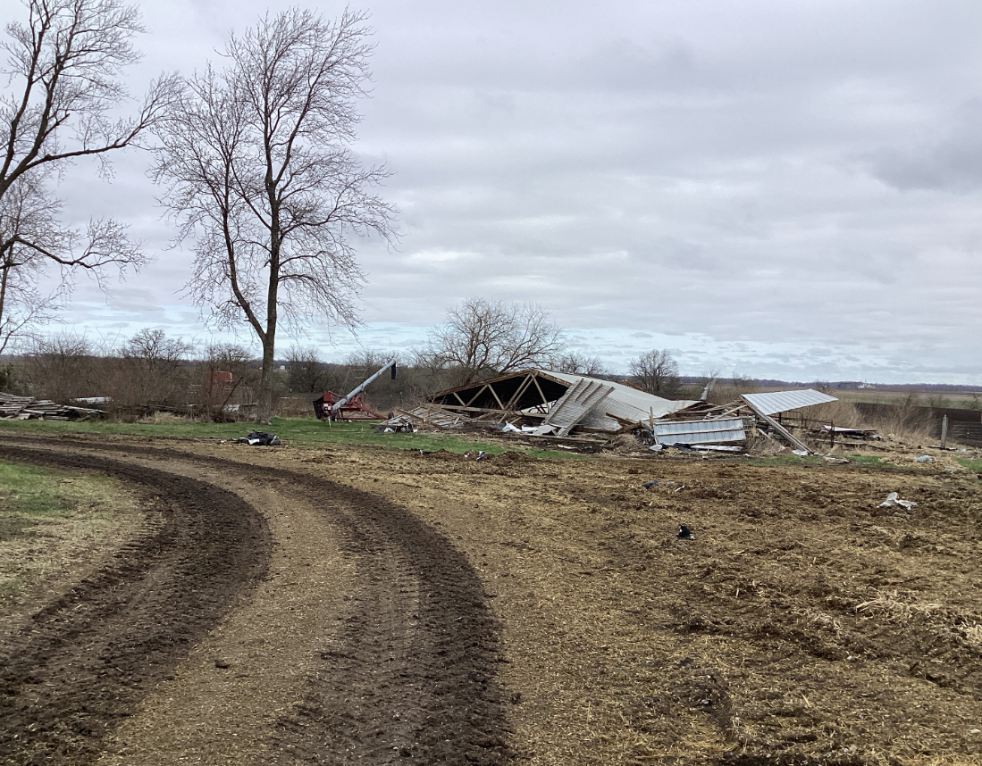
0452 PM Tornado 1 NW Rardin 39.61N 88.11W
03/19/2025 Coles IL NWS Storm Survey
EF1, peak wind speed 110 mph. Path length
0.7 miles, max width 50 yards. Structural
damage was found near the start of the
track, west of the intersection of county
roads 1600N and 2000E. Here, a farm
outbuilding was destroyed, and siding torn
off a nearby house.
0457 PM Tstm Wnd Dmg 2 W Oakland 39.66N 88.07W
03/19/2025 Douglas IL NWS Storm Survey
Large branch broken off.
0500 PM Funnel Cloud Oakland 39.65N 88.03W
03/19/2025 Coles IL Public
0500 PM Tstm Wnd Dmg Oakwood 40.12N 87.78W
03/19/2025 Vermilion IL Public
Semi truck overturned on I-74 in Oakwood IL.
Social media report with photo.
0502 PM Hail Newman 39.80N 87.98W
03/19/2025 M1.25 Inch Douglas IL Cocorahs
0506 PM Tstm Wnd Dmg Brocton 39.72N 87.93W
03/19/2025 Edgar IL Public
Tree down. Social media report.
0515 PM Tstm Wnd Gst Lawrenceville Airport 38.76N 87.60W
03/19/2025 M60 MPH Lawrence IL ASOS
0530 PM Tstm Wnd Dmg 2 W Bethany 39.64N 88.78W
03/19/2025 Moultrie IL Broadcast Media
Outbuilding damaged from strong gusty winds.
0544 PM Hail Boody 39.76N 89.05W
03/19/2025 M1.00 Inch Macon IL Emergency Mngr
Quarter size hail at Nevada road and Mt
Auburn road.
0550 PM Hail Blue Mound 39.70N 89.12W
03/19/2025 M1.00 Inch Macon IL Fire Dept/Rescue
0655 PM Tstm Wnd Gst 3 NW Willard Airport 40.07N 88.32W
03/19/2025 M62 MPH Champaign IL Public
0656 PM Tstm Wnd Gst Willard Airport 40.04N 88.28W
03/19/2025 M64 MPH Champaign IL ASOS
Westerly wind gust 64 mph at Champaign
airport.
0735 PM Tstm Wnd Gst 1 NE Vermilion Regional 40.20N 87.59W
03/19/2025 M62 MPH Vermilion IL AWOS
AWOS station KDNV Danville Arpt.
&&
$$
Environment
 |
 |
 |
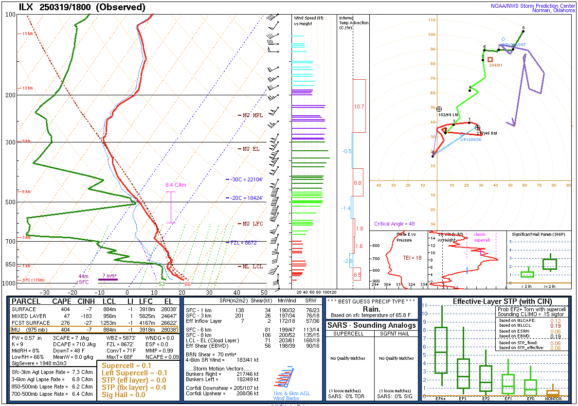
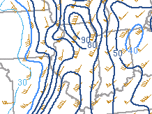
| KILX sounding from 1 PM CDT (18Z) March 19 | 0-6 km wind shear (contours) and shear vectors (wind barbs). Shear vectors were nearly parallel to the incoming dry line (oriented north to south), favoring a linear storm mode supportive of damaging winds and brief tornadoes. Shear magnitude was over 70 kt area-wide. For reference, values over 35 kt are favorable for tornadoes. | Dewpoint temperatures at 2pm, as storms were developing across western IL immediately ahead of a dryline. These dewpoints are only marginally supportive of severe weather (higher values imply more instability, which is a necessary ingredient for severe thunderstorms), but this limiting factor was offset by the high environmental wind shear. |
 |
||
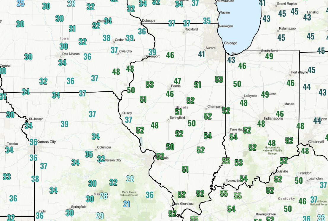
| Maximum non-thunderstorm, southerly wind gusts measured as of 5pm. This suggests lapse rates in the low levels were steep, favoring strong wind gusts and enhancing the tornado potential with any storms. These winds were strong enough to create difficult driving conditions for high profile vehicles and even result in brief visibility reductions from localized blowing dust. | Figure 5: Caption | Figure 6: Caption |
| Figure 7: Caption | Figure 8: Caption | Figure 9: Caption |
Photos & Video
Header
 |
 |
||
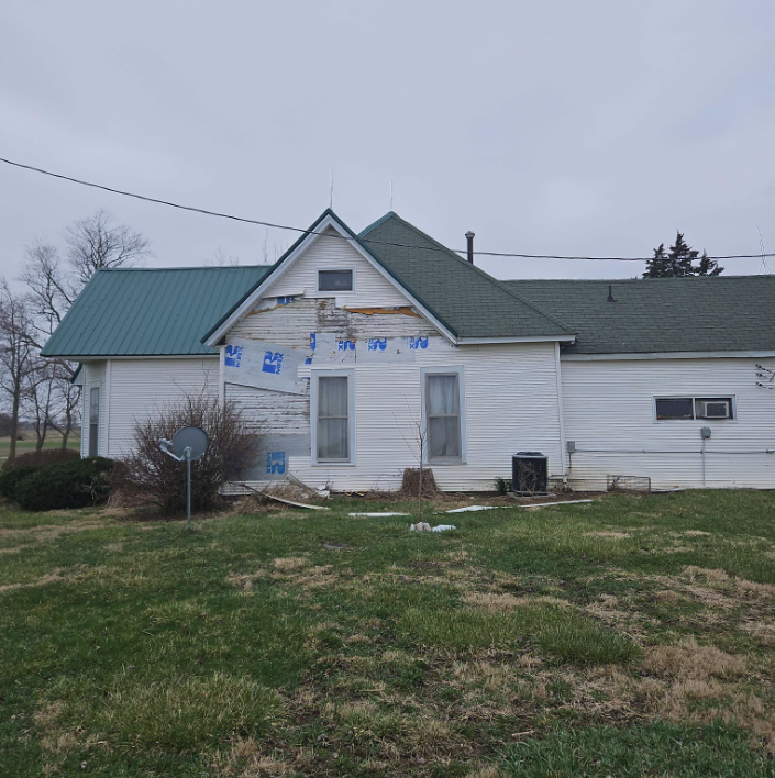
| Siding damage to a house northwest of Rardin, caused by tornado. (NWS Survey) |
Collapsed farm outbuilding northwest of Rardin, caused by tornado. (NWS Survey) |
Caption (source) |
Caption (source) |
Radar
Header
 |
 |
||
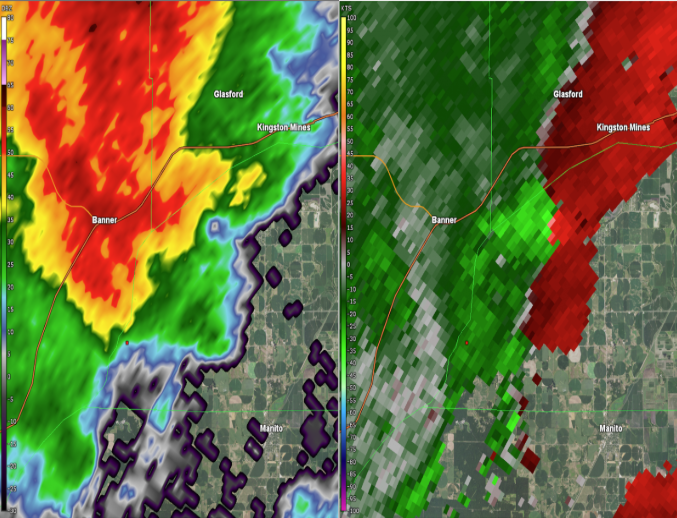
| Radar image near Banner, IL at 2:47 PM CDT showing reflectivity (left) and gate to gate rotation on storm relative velocity (right). | Radar image near Rardin, IL at 2:47 PM CDT showing reflectivity (left) and rotation on storm relative velocity (right). | Caption | Caption |
Additional Information
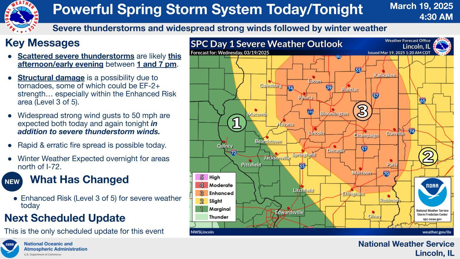
The Forecast
 |
 |
 |
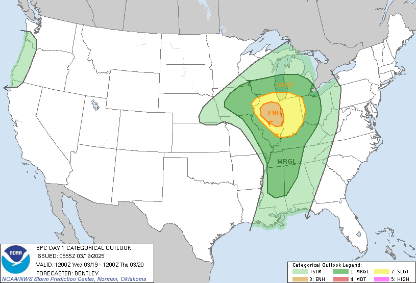 |
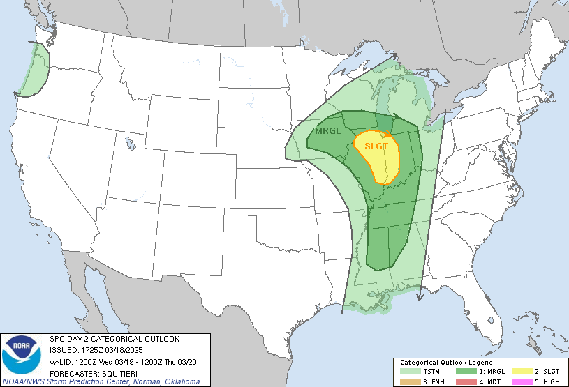
| Locally generated graphic displaying SPC's Day 1 outlook and key messages | SPC Day 3 Categorical Outlook | SPC Day 2 Categorical Outlook | SPC Day 1 Categorial Outlook |
 |
 |
 |
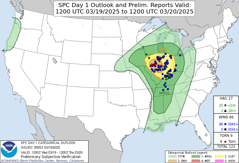 |
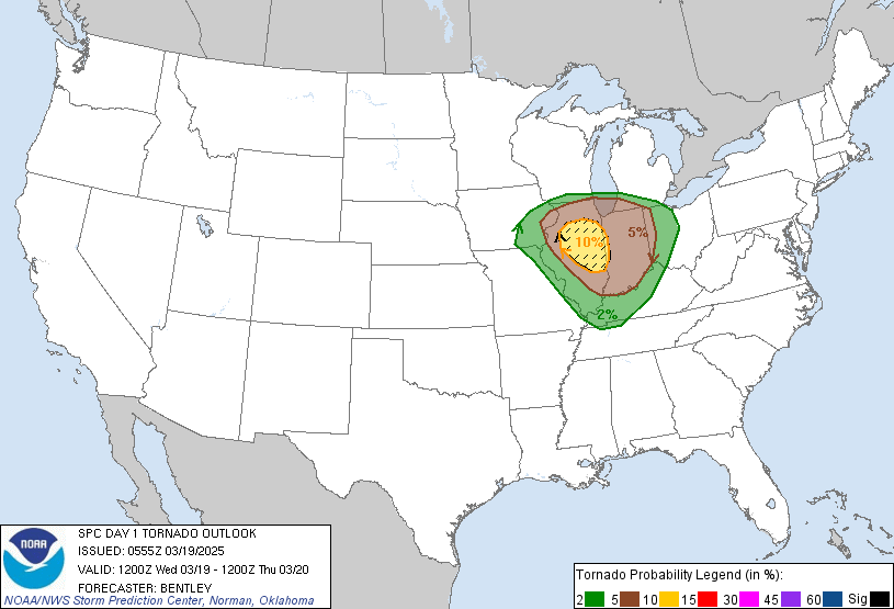
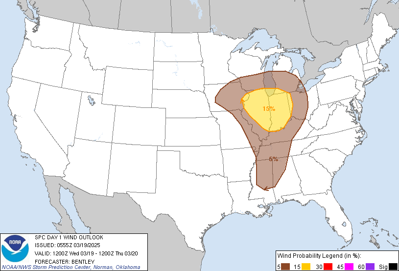
| SPC Day 1 Tornado Outlook | SPC Day 1 Wind Outlook | SPC Day 1 Hail Outlook | SPC Day 1 Outlook Verification |
 |
Media use of NWS Web News Stories is encouraged! Please acknowledge the NWS as the source of any news information accessed from this site. |
|