National Weather Service United States Department of Commerce

Overview

Severe thunderstorms moved across central and western Illinois during the late afternoon and evening hours of March 15th. Four tornadoes have been reported in the Lincoln NWS coverage area:

  • Northwest Fulton County   EF-1
    (North-Northwest to North-Northeast of Avon)
  • Central Peoria County   EF-2
    (NW of Trivoli to SW of Kickapoo)
  • Sangamon County   EF-1
    (Southwest Springfield)
  • City of Peoria / Peoria Heights   EF-0


Track overview map
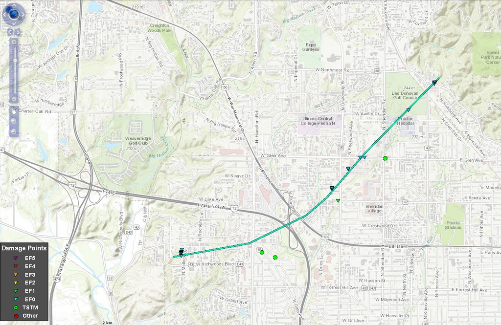
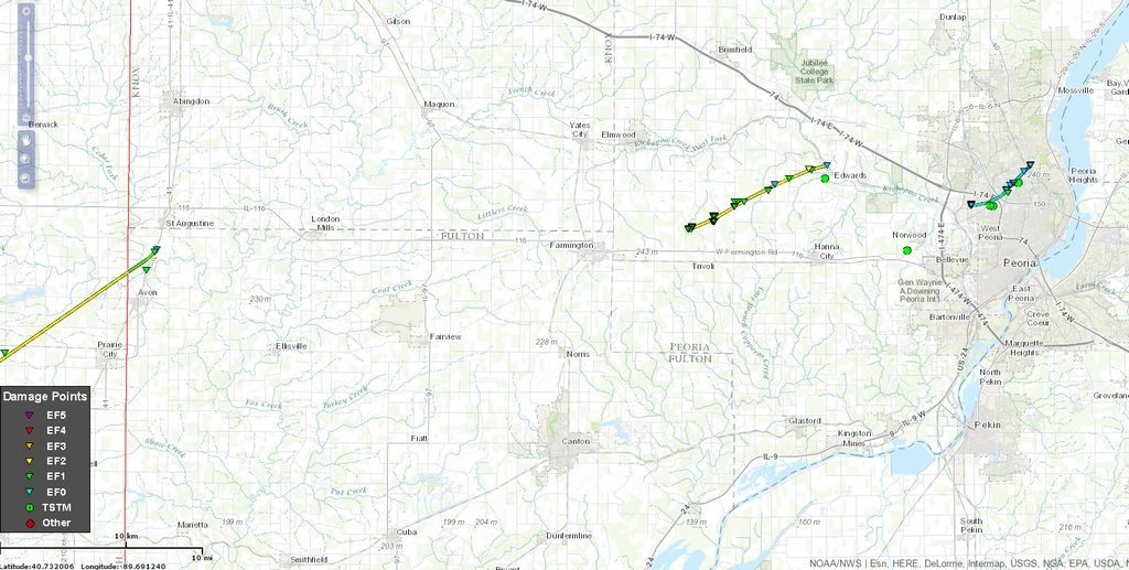
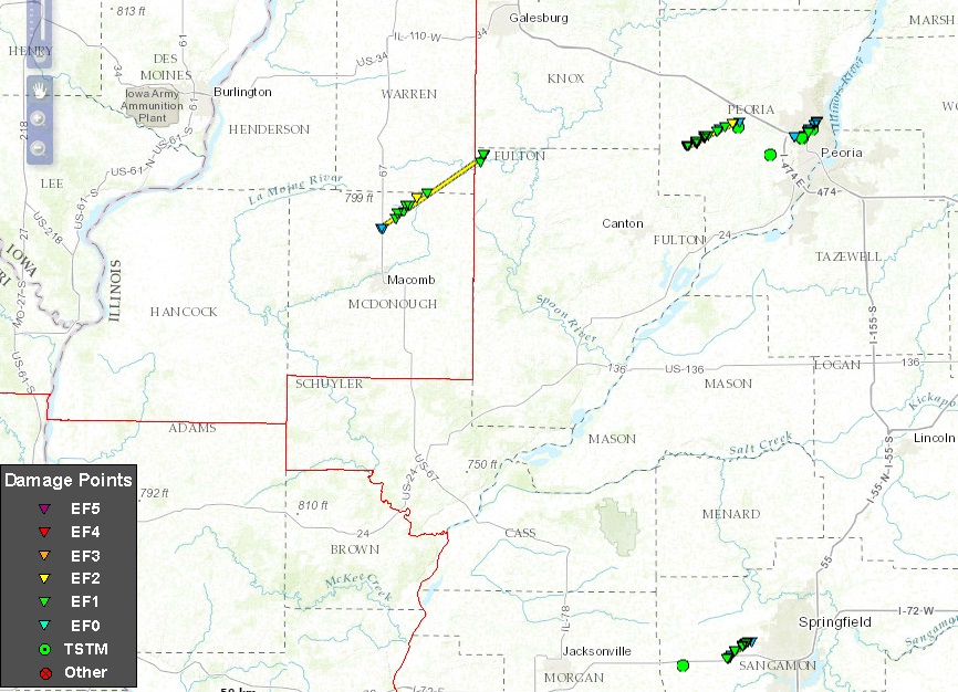
Overview Map of Tornado Tracks (Click for larger image)
Image Tornado tracks from central Illinois (Macomb to Peoria area) Track of Springfield-area tornado
Storm Prediction Center Severe
Weather Outlook for March 15, 2016
Tornado tracks of Fulton and 
Peoria County storms
Tornado track of Sangamon County storm

Tornadoes:

Tornado #1: 1.4 miles north-northwest to 2.6 miles north-northeast of Avon, IL
Northwest FULTON COUNTY

Date 03/15/16
Time (Local) 6:56 pm - 7:00 pm
EF Rating EF-1
Est. Peak Winds 90 mph
Path Length 2 miles
Max Width 100 yards
Injuries/Deaths None

Summary:

This is the same tornado that tracked from northern McDonough County into southeast Warren County, which damaged properties between Little Swan Lake and Avon.

The tornado crossed into northwest Fulton County about 1.4 miles north-northwest of Avon at 6:56 pm. The tornado damaged trees near Swan Creek before damaging more trees along Illinois Route 41, about 2.5 miles north-northeast of Avon. The tornado dissipated shortly afterwards east of the highway at 7:00 pm.


Tornado #2: 2 miles northwest of Trivoli to 2.7 miles southwest of Kickapoo
PEORIA COUNTY

Date 03/15/2016
Time (Local) 7:42 pm to 7:57 pm
EF Rating EF-2
Est. Peak Winds 125 mph
Path Length 7.1 miles
Max Width 1/4 mile
Injuries/Deaths None

Summary:

The tornado touched down 2.0 miles northwest of Trivoli, roughly one-quarter mile west of Quarry Road. A garage and house roofs were damaged, a car was picked up and thrown 50 yards into a field, a pickup truck was damaged and several trees were snapped. As the tornado approached Trivoli Road it developed multiple vorticies and then widened to about 1/4 mile across. Several outbuildings and grain bins were destroyed, house roofs were damaged and numerous trees were uprooted. Near Texas Road & Cottonwood Road the roof of a church was severely damaged and several trees were snapped. As the tornado continued tracking to the northeast, additional trees and outbuildings were damaged. The worst damage occurred to a home on Southport Road (Route 8) between Cut-off Road and Kramm Road, where the roof was completely torn off of the house, outbuildings were damaged and a tree was ripped out of the ground and thrown. The tornado dissipated about 1 mile to the east-northeast, near Kickapoo Creek, which was about 3 miles southwest of the town of Kickapoo.

Radar/Photo Radar/Photo Radar/Photo Radar/Photo
Tornado Northwest
of Hanna City

Photo by Jerry Funfsinn
Damage near the start of the tornado - 2 miles north of Trivoli
NWS Photo
Tornado Damage to church roof
3 miles NNE of Trivoli

NWS Photo
Outbuilding damage near Southport Rd - 4 miles north of Hanna City      NWS Photo

Tornado #3 - 2.4 miles west of Curran to 6.6 miles west-southwest of downtown Springfield
SANGAMON COUNTY

Date 03/15/2016
Time (Local) 7:44 pm to 7:50 pm
EF Rating EF-1
Est. Peak Winds 105 mph
Path Length 3.5 miles
Max Width 75 yards
Injuries/Deaths None

Summary:

This tornado touched down along Werner Road, about 3/4 mile west of the intersection with Farmingdale Road. A few pine trees were broken off in this area, and a home lost some shingles. The tornado tracked across mainly open fields and crossed I-72 just east of Farmingdale Road at 7:45 pm. It tracked northeast and damaged a house along Bunker Hill Road, blowing out a few windows, removing some shingles, and breaking several trees. It continued across open fields and caused some minor shingle damage to a home along Emerson Road about a quarter mile south of Iles Avenue, and also uprooted and snapped a few trees. Continuing northeast, it caused significant damage to a home along Iles Avenue, about 0.5 mile east of the intersection with Emerson Road, removing most of the roof and blowing out a wall on the west side of the building. The strongest part of the tornado (wind speeds 100-105 mph) occurred at this location at 7:49 pm. Across the street, a barn lost its roof, and several trees were snapped off. The tornado lifted in an open field shortly afterward, at 7:50 pm.

Radar/Photo Radar/Photo Radar/Photo
Springfield Tornado
Photo by Chris Heater
Tornado Damage southwest
of Springfield

NWS Photo
Roof torn off of home by Tornado SW side of Springfield
NWS Photo

Tornado - #4 Peoria / Peoria Heights
PEORIA COUNTY

Date 03/15/2016
Time (Local) 8:05 pm to 8:14 pm
EF Rating EF-0
Est. Peak Winds 80 mph
Path Length 3.8 miles
Max Width 200 yards
Injuries/Deaths None

Summary:

A tornado touched down in Peoria, northwest of the intersection of Richwoods Boulevard & Molleck Drive. Damage was done to the roof, gutters, soffit and ceiling tiles of the St. Francis Woods Supportive Living Center. The tornado intermittently touched down along a path to the northeast through the city of Peoria. Damage was done to roofs and trees near University & Christine, the Farmer's Market at the Metro Centre shopping facility, and trees on the Donovan Golf Course. The tornado broke a power pole, snapped a tree which fell onto a garage, and damaged shingles and siding to homes in Peoria Heights on Prospect & Wickwood Roads. The tornado dissipated shortly afterwards, before it approached Forest Park.


The Enhanced Fujita (EF) Scale classifies tornadoes into the following categories:

EF0
Weak

65-85 mph
EF1
Moderate
86-110 mph
EF2
Significant
111-135 mph
EF3
Severe
136-165 mph
EF4
Extreme
166-200 mph
EF5
Catastrophic
200+ mph
ef-scale


Storm Reports

PRELIMINARY LOCAL STORM REPORT...SUMMARY
NATIONAL WEATHER SERVICE LINCOLN IL
1200 AM CDT WED MAR 16 2016

..TIME...   ...EVENT...      ...CITY LOCATION...     ...LAT.LON...
..DATE...   ....MAG....      ..COUNTY LOCATION..ST.. ...SOURCE....
            ..REMARKS..

0625 PM     HAIL             WINCHESTER              39.63N 90.46W
03/15/2016  M0.75 INCH       SCOTT              IL   LAW ENFORCEMENT

0638 PM     HAIL             2 N ALSEY               39.59N 90.43W
03/15/2016  M1.00 INCH       SCOTT              IL   TRAINED SPOTTER

            BETWEEN ALSEY AND WINCHESTER. FROM WFO LSX.

0645 PM     HAIL             3 SSW JACKSONVILLE      39.69N 90.26W
03/15/2016  M1.00 INCH       MORGAN             IL   TRAINED SPOTTER

0659 PM     HAIL             JACKSONVILLE            39.73N 90.23W
03/15/2016  M2.00 INCH       MORGAN             IL   CO-OP OBSERVER

0720 PM     HAIL             ALEXANDER               39.72N 90.05W
03/15/2016  M2.75 INCH       MORGAN             IL   TRAINED SPOTTER

0728 PM     FUNNEL CLOUD     1 N WAVERLY             39.61N 89.95W
03/15/2016                   MORGAN             IL   FIRE DEPT/RESCUE

0733 PM     HAIL             NEW BERLIN              39.73N 89.91W
03/15/2016  M1.75 INCH       SANGAMON           IL   TRAINED SPOTTER

            ON I-72...HAIL RANGED FROM QUARTER TO GOLF BALL SIZE

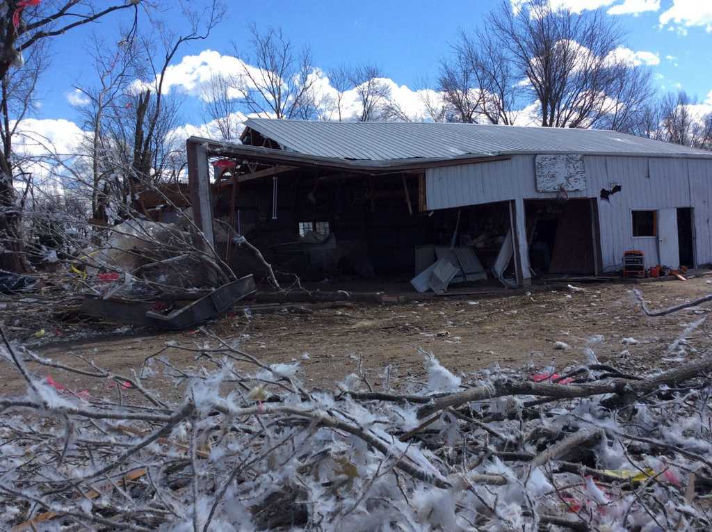
0742 PM     TORNADO          2 NW TRIVOLI            40.71N 89.91W
03/15/2016  EF2              PEORIA             IL   NWS STORM SURVEY

            A CAR WAS PICKED UP AND THROWN 50 YARDS INTO A FIELD.
            ROOF DAMAGE TO SEVERAL HOMES AND A CHURCH. ROOF
            COMPLETELY TORN OFF ONE HOUSE. NUMEROUS TREES WERE
            SNAPPED.
0744 PM     TORNADO          2 W CURRAN              39.74N 89.80W
03/15/2016  EF1              SANGAMON           IL   NWS STORM SURVEY

            MOST OF ROOF BLOWN OFF ONE HOUSE WHICH SIGNIFICANTLY
            DAMAGED AN OUTSIDE WALL. MINOR ROOF AND DOOR DAMAGE AS
            WELL AS BROKEN WINDOWS TO SEVERAL OTHER BUILDINGS.
            NUMEROUS TREES SNAPPED OR BLOWN OVER.
0745 PM     HAIL             5 E PLEASANT PLAINS     39.87N 89.83W
03/15/2016  M0.88 INCH       SANGAMON           IL   TRAINED SPOTTER

0748 PM     HAIL             1 W KICKAPOO            40.80N 89.77W
03/15/2016  M1.75 INCH       PEORIA             IL   EMERGENCY MNGR

0750 PM     FUNNEL CLOUD     1 S SPRINGFIELD         39.77N 89.64W
03/15/2016                   SANGAMON           IL   TRAINED SPOTTER

0800 PM     TSTM WND DMG     NORWOOD                 40.71N 89.70W
03/15/2016                   PEORIA             IL   TRAINED SPOTTER

            HOUSES DAMAGED INCLUDING AWNING, GUTTER, AND FENCE

0800 PM     HAIL             4 SW ALTA               40.78N 89.69W
03/15/2016  M1.50 INCH       PEORIA             IL   TRAINED SPOTTER

0805 PM     TORNADO          PEORIA                  40.74N 89.61W
03/15/2016  EF0              PEORIA             IL   NWS STORM SURVEY

            TORNADO STARTED 4 MILES NW OF DOWNTOWN PEORIA. DAMAGE WAS
            DONE TO AN ASSISTED LIVING CENTER, HOUSE ROOFS, TREES, A
            SHOPPING CENTER, AND GOLF COURSE AS IT TRACKED NORTHEAST
            INTO PEORIA HEIGHTS.
0805 PM     HAIL             GLASFORD                40.57N 89.81W
03/15/2016  M1.00 INCH       PEORIA             IL   MESONET

0805 PM     HAIL             PEORIA                  40.74N 89.61W
03/15/2016  M1.75 INCH       PEORIA             IL   LAW ENFORCEMENT

0807 PM     HAIL             5 NW PEORIA             40.80N 89.68W
03/15/2016  M1.00 INCH       PEORIA             IL   CO-OP OBSERVER

0833 PM     HAIL             EAST PEORIA             40.67N 89.55W
03/15/2016  M0.75 INCH       TAZEWELL           IL   TRAINED SPOTTER

0838 PM     HAIL             BEASON                  40.15N 89.20W
03/15/2016  M1.00 INCH       LOGAN              IL   EMERGENCY MNGR

0842 PM     HAIL             HALLSVILLE              40.15N 89.13W
03/15/2016  M1.75 INCH       DE WITT            IL   EMERGENCY MNGR

0848 PM     HAIL             CLINTON                 40.15N 88.96W
03/15/2016  M0.88 INCH       DE WITT            IL   TRAINED SPOTTER

0854 PM     HAIL             1 E HEYWORTH            40.31N 88.96W
03/15/2016  M0.75 INCH       MCLEAN             IL   PUBLIC

0907 PM     HAIL             SECOR                   40.74N 89.14W
03/15/2016  M1.50 INCH       WOODFORD           IL   EMERGENCY MNGR

1008 PM     HAIL             WESTVILLE               40.04N 87.64W
03/15/2016  M1.00 INCH       VERMILION          IL   EMERGENCY MNGR

1012 PM     HAIL             S DANVILLE              40.14N 87.62W
03/15/2016  M0.88 INCH       VERMILION          IL   EMERGENCY MNGR


&&

Additional Information

Summaries from other NWS Offices


nws logo Media use of NWS Web News Stories is encouraged!
Please acknowledge the NWS as the source of any news information accessed from this site.
nws logo