Overview
|
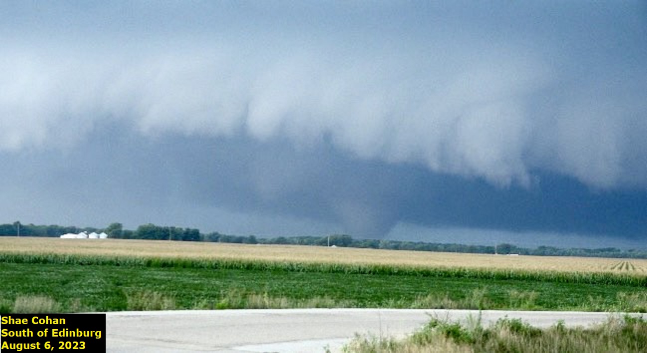
A long track tornado passed between Springfield and Taylorville on August 6th. It was on the ground for close to an hour, and rated as a peak intensity of EF2 northeast of Taylorville. Additional severe weather, mainly in the form of tree damage or large hail, occurred across east central and southeast Illinois. |
 Tornado south of Edinburg around 6:25 pm. Photo by Shae Cohan. |
Tornadoes
|
Sangchris Lake/Willeys Tornado
|
||||||||||||||||
|
||||||||||||||||
The Enhanced Fujita (EF) Scale classifies tornadoes into the following categories:
| EF0 Weak 65-85 mph |
EF1 Moderate 86-110 mph |
EF2 Significant 111-135 mph |
EF3 Severe 136-165 mph |
EF4 Extreme 166-200 mph |
EF5 Catastrophic 200+ mph |
 |
|||||
Photos & Video
Header
| Caption (source) |
Caption (source) |
Caption (source) |
Caption (source) |
Radar
Lincoln Doppler radar images
 |
 |
 |
|
| 6:20 pm reflectivity and storm relative motion image. A hook echo is visible on the left panel northwest of Kincaid, with a strong rotation on the right panel. | 6:30 pm images, clockwise from top left: Reflectivity, storm relative motion, normalized rotation, correlation coefficient. | 6:48 pm reflectivity and storm relative motion images, as the tornado is at its strongest point northeast of Taylorville. | Caption |
Storm Reports
Preliminary Local Storm Report...Summary
National Weather Service Lincoln IL
1139 PM CDT Sun Aug 6 2023

..TIME...   ...EVENT...      ...CITY LOCATION...     ...LAT.LON...
..DATE...   ....MAG....      ..COUNTY LOCATION..ST.. ...SOURCE....
            ..REMARKS..

0528 PM     Funnel Cloud     3 NNW Berlin            39.79N 89.92W
08/06/2023                   Sangamon           IL   Public


0555 PM     Tstm Wnd Dmg     3 E Southern View       39.76N 89.60W
08/06/2023                   Sangamon           IL   Newspaper

            Power line down on E. Lake Shore Dr. Time
            estimated from radar.

0610 PM     Tornado          2 ENE Glenarm           39.63N 89.61W
08/06/2023                   Sangamon           IL   Storm Chaser

            Touched down 3 miles southwest of New City.

0611 PM     Hail             4 WSW Berry             39.68N 89.53W
08/06/2023  E1.00 inch       Sangamon           IL   Public

            Report from mPING: Quarter (1.00 in.).

0613 PM     Tornado          2 NNE Pawnee            39.62N 89.57W
08/06/2023                   Sangamon           IL   Emergency Mngr

            A farmstead was damaged near the
            intersection of Cotton Hill Road and
            Skaggs Road. The roof was damaged and a
            few trees were uprooted.

0633 PM     Hail             5 S Rochester           39.68N 89.54W
08/06/2023  E1.00 inch       Sangamon           IL   Public


0646 PM     Tornado          3 NE Taylorville        39.58N 89.23W
08/06/2023                   Christian          IL   Emergency Mngr

            Several homes and garages were damaged along
            1600 East Road. Numerous trees and power
            poles were snapped as well.

0650 PM     Hail             7 N Taylorville         39.66N 89.30W
08/06/2023  E2.00 inch       Christian          IL   Public


0700 PM     Hail             1 NW Taylorville        39.56N 89.31W
08/06/2023  E1.00 inch       Christian          IL   Public
Environment
Insert synoptic summary.
 |
 |
 |
| Figure 1: WPC Surface Analysis 08/06/2023 12z | Figure 2: WPC Surface Analysis 08/06/2023 18z | Figure 3: WPC Surface Analysis 08/07/2023 00z |
Near-storm environment summary.
 |
 |
| Figure 4: ILX Sounding 08/06/2023 12z | Figure 5: ILX Sounding 08/07/2023 00z |
Additional environmental data.
 |
 |
 |
| Figure 7: SPC Day 4 Probabilistic Outlook | Figure 8: SPC Day 3 Categorical Outlook | Figure 9: SPC Day 2 Categorical Outlook |
 |
 |
 |
 |
| Figure 10: SPC Day 1 Categorical Outlook | Figure 11: SPC Day 1 Hail Outlook | Figure 12: SPC Day 1 Tornado Outlook | Figure 12: SPC Day 1 Wind Outlook |
 |
Media use of NWS Web News Stories is encouraged! Please acknowledge the NWS as the source of any news information accessed from this site. |
 |