
Record setting heat is expected over the next several days from the Intermountain West through the northern Plains. Furthermore, fire weather concerns increase with dry and breezy conditions. Meanwhile, heavy rainfall and severe thunderstorm threats for the Ohio/Tennessee Valleys, central Appalachians and Southeast today. The threat shifts to central Gulf Coast and across central Texas this week. Read More >
Overview
|
A major winter storm impacted a large area from the central Plains to the mid-Atlantic coast, from Saturday, January 4th through Monday, January 6th. In central Illinois, snow was the primary precipitation type, although some sleet and freezing drizzle did occur, especially south of the I-70 corridor. Snowfall amounts ranged from 6 to 10 inches in much of central Illinois south of a Rushville-Lincoln-Peoria line, with amounts tapering off sharply north of there. Peoria picked up an inch or two of snow, while only trace amounts occurred north of there in Stark and Marshall Counties. This overview covers the storm's impacts across central and southeast Illinois. Additional reviews are available at the following links:
|
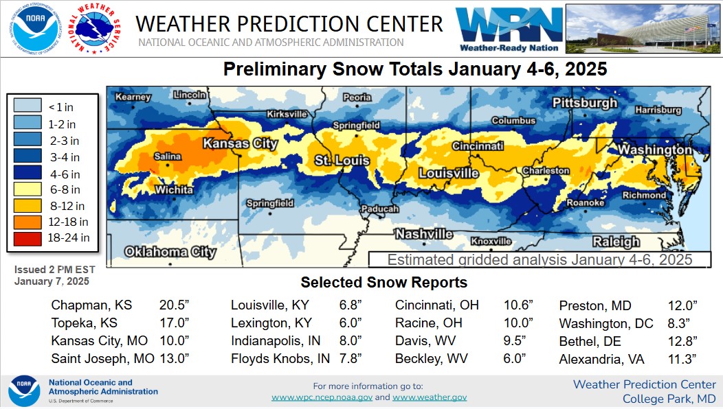 The winter storm impacted areas from Kansas east to Delaware. Image from the NWS Weather Prediction Center. |
Snow/Ice
...WINTER STORM (JANUARY 5-6) SNOWFALL REPORTS...

Location                     Amount    Time/Date       Lat/Lon

...Illinois...

...Cass County...
Beardstown                   9.0 in    0937 AM 01/06   40.01N/90.43W
Virginia                     8.0 in    1009 AM 01/06   39.95N/90.21W

...Champaign County...
1 SSE Savoy                  4.0 in    0742 AM 01/06   40.06N/88.25W
1 NW Urbana                  3.0 in    1049 AM 01/06   40.12N/88.22W
3 SW Champaign               3.0 in    0824 AM 01/06   40.08N/88.30W
Ogden                        2.7 in    0600 AM 01/06   40.11N/87.96W

...Christian County...
Pana                         11.5 in   0846 AM 01/06   39.39N/89.09W
1 ENE Taylorville            10.0 in   0851 AM 01/06   39.56N/89.28W
Pana                         8.0 in    0729 AM 01/06   39.38N/89.08W

...Clay County...
2 SE Clay City               6.0 in    0758 AM 01/06   38.68N/88.33W

...Coles County...
1 WNW Mattoon                9.0 in    0801 AM 01/06   39.48N/88.38W

...Crawford County...
Robinson                     6.0 in    0958 AM 01/06   39.01N/87.73W

...De Witt County...
Kenney                       5.3 in    0902 AM 01/06   40.10N/89.08W
Clinton                      5.0 in    0920 AM 01/06   40.15N/88.96W
Farmer City                  3.0 in    0819 AM 01/06   40.25N/88.64W
Clinton                      3.0 in    0745 AM 01/06   40.15N/88.96W

...Douglas County...
Arthur                       8.0 in    0630 AM 01/06   39.72N/88.47W

...Effingham County...
Effingham                    9.0 in    0825 AM 01/06   39.12N/88.55W
1 E Watson                   6.7 in    0918 AM 01/06   39.02N/88.55W

...Fulton County...
Lewistown                    3.6 in    0510 AM 01/06   40.40N/90.16W
1 NE Fairview                2.0 in    0915 AM 01/06   40.64N/90.16W
1 NW Banner                  2.0 in    0857 AM 01/06   40.52N/89.92W
1 ENE Canton                 2.0 in    0833 AM 01/06   40.56N/90.03W

...Logan County...
NWS Lincoln                  6.9 in    0600 AM 01/06   40.15N/89.34W

...Macon County...
1 S Mount Zion               8.0 in    0720 AM 01/06   39.76N/88.87W
1 S Decatur                  7.7 in    0905 AM 01/06   39.83N/88.95W
Decatur                      7.0 in    0830 AM 01/06   39.85N/88.96W

...Mason County...
Bath                         6.0 in    0928 AM 01/06   40.19N/90.14W
Manito                       2.0 in    0853 AM 01/06   40.42N/89.78W

...McLean County...
Lexington                    3.0 in    0926 AM 01/06   40.64N/88.79W
Towanda                      2.0 in    0953 AM 01/06   40.56N/88.91W

...Menard County...
Petersburg                   6.2 in    0906 AM 01/06   40.01N/89.85W

...Morgan County...
Jacksonville                 9.0 in    0707 AM 01/06   39.73N/90.22W
Alexander                    8.0 in    0945 AM 01/06   39.73N/90.04W
Jacksonville                 8.0 in    0930 AM 01/06   39.73N/90.23W
3 ESE Jacksonville           8.0 in    0908 AM 01/06   39.72N/90.18W

...Moultrie County...
3 NW Kirksville              8.0 in    0928 AM 01/06   39.60N/88.71W
Lovington                    6.8 in    1009 AM 01/06   39.72N/88.63W

...Peoria County...
3 SW Glasford                2.0 in    0947 AM 01/06   40.55N/89.85W
2 E Elmwood                  2.0 in    0921 AM 01/06   40.78N/89.94W
1 N West Peoria              1.2 in    0912 AM 01/06   40.72N/89.63W

...Piatt County...
Cisco                        5.0 in    0750 AM 01/06   40.01N/88.73W

...Richland County...
1 NW Claremont               7.5 in    0710 AM 01/06   38.73N/87.99W
1 S Parkersburg              5.0 in    1130 AM 01/06   38.57N/88.06W

...Sangamon County...
Dawson                       9.5 in    1021 AM 01/06   39.86N/89.46W
1 N Grandview                8.2 in    0600 AM 01/06   39.82N/89.62W
3 SE Salisbury               7.0 in    1026 AM 01/06   39.87N/89.76W

...Schuyler County...
3 WNW Browning               7.3 in    0700 AM 01/06   40.14N/90.42W
1 E Littleton                2.0 in    0935 AM 01/06   40.23N/90.60W

...Shelby County...
Herrick                      4.0 in    1009 AM 01/06   39.22N/88.99W

...Tazewell County...
Washington                   2.3 in    1101 AM 01/06   40.71N/89.40W
East Peoria                  2.0 in    0921 AM 01/06   40.66N/89.57W
Pekin                        1.5 in    0914 AM 01/06   40.57N/89.63W
3 NW Washington              1.3 in    0758 AM 01/06   40.73N/89.45W

...Vermilion County...
Georgetown                   6.5 in    0938 AM 01/06   39.98N/87.64W
Westville                    5.0 in    0938 AM 01/06   40.04N/87.64W
Danville                     2.1 in    0650 AM 01/06   40.14N/87.63W

...Woodford County...
1 S Eureka                   3.5 in    0841 AM 01/06   40.70N/89.27W
Eureka                       3.0 in    0943 AM 01/06   40.72N/89.27W
1 WSW El Paso                3.0 in    0908 AM 01/06   40.74N/89.03W

Observations are collected from a variety of sources with varying
equipment and exposures. We thank all volunteer weather observers
for their dedication. Not all data listed are considered official.
Photos & Video
.jpg) |
| Snow in Decatur IL (Source: Paul Hadfield) |
Environment
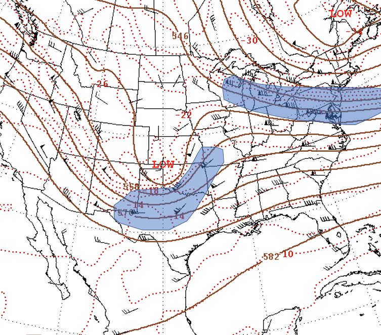
Upper air analysis from the morning of January 5th showed a vigorous short-wave trough over the Central Plains with a strong jet streak (depicted in blue shading in Figure 1 below) from Texas northeastward into Missouri. At the same time, a second jet streak was analyzed further northeast from Wisconsin southeastward to the Mid-Atlantic states. With upper divergence focused in the left exit region and the right entrance region of jet streaks, this coupled structure allowed for maximum upper-level divergence and corresponding synoptic lift across Kansas, Missouri, and Illinois.
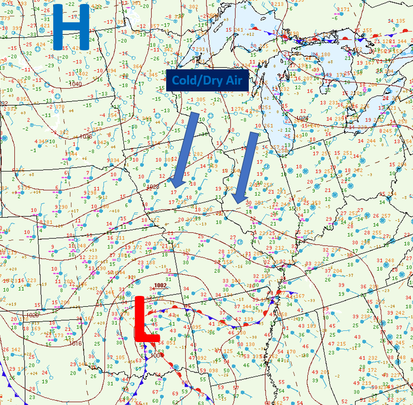
At the surface, a 1002mb low had formed within this area of favorable upper dynamics over Oklahoma, and a significant swath of snow, sleet, and freezing rain was falling across Kansas and Missouri. Further northeast, light snow was beginning to spread into south-central Illinois; however, it was encountering a dry northeasterly boundary layer flow courtesy of a 1040mb high anchored over the Dakotas (Figure 2).
 |
 |
 |
| Figure 1: 500 mb analysis the morning of Sunday, January 6th | Figure 2: Surface map at 6 am Sunday, January 6th |
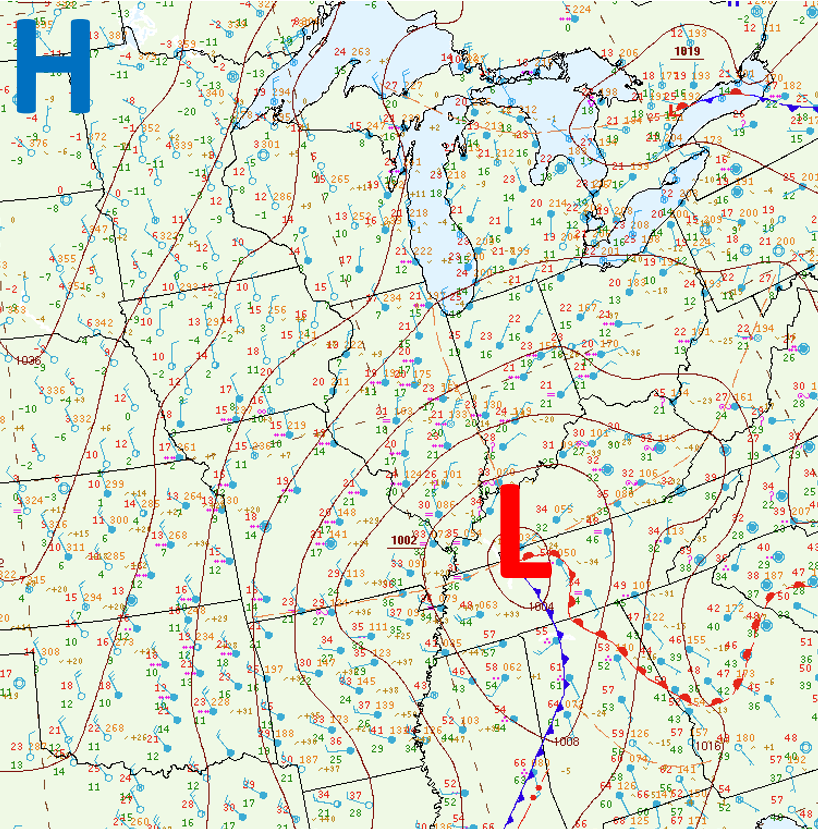
Figure 3: Surface map at 9 pm Sunday, January 6th |
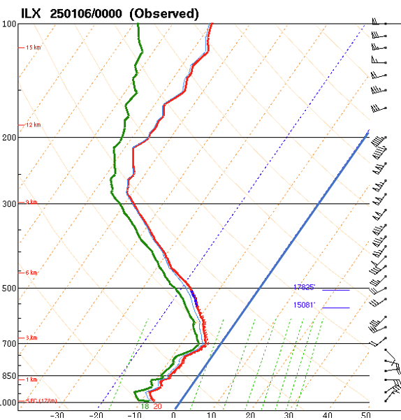
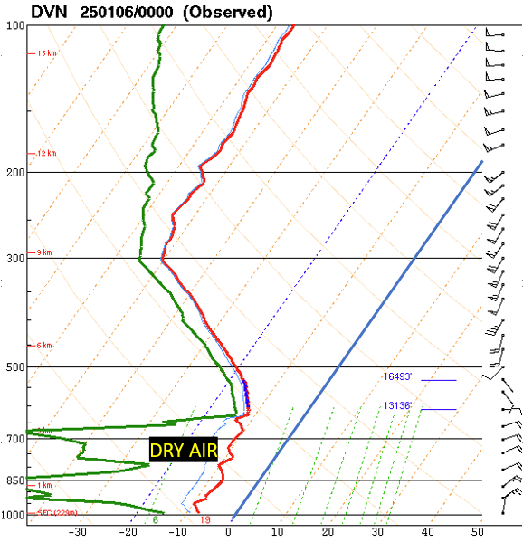
As the day progressed, the snow gradually spread further northward, but continued to have considerable difficulty fighting the dry inflow from the northeast. In fact, while light to moderate snow was ongoing throughout the day south of the I-74 corridor, locations to the north remained largely dry. The images below show data collected from upper air balloon launches during the early evening of January 5th at Lincoln NWS (Figure 4) and Quad Cities NWS (Figure 5). The red line depicts the temperature trace throughout the depth of the atmosphere while the green line represents the dewpoint. When these two lines are close together, this indicates areas of saturation. When the two are far apart, this shows where the airmass is dry. Note how the sounding indicates a fully saturated profile in Lincoln, but maintains a significant dry layer from the surface up to about 12,000 ft aloft at the Quad Cities.
 |
 |
|
| Figure 4: Lincoln weather balloon sounding from 6 pm Sunday, January 6th | Figure 5: Davenport IA weather balloon sounding from 6 pm Sunday, January 6th |
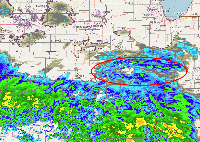
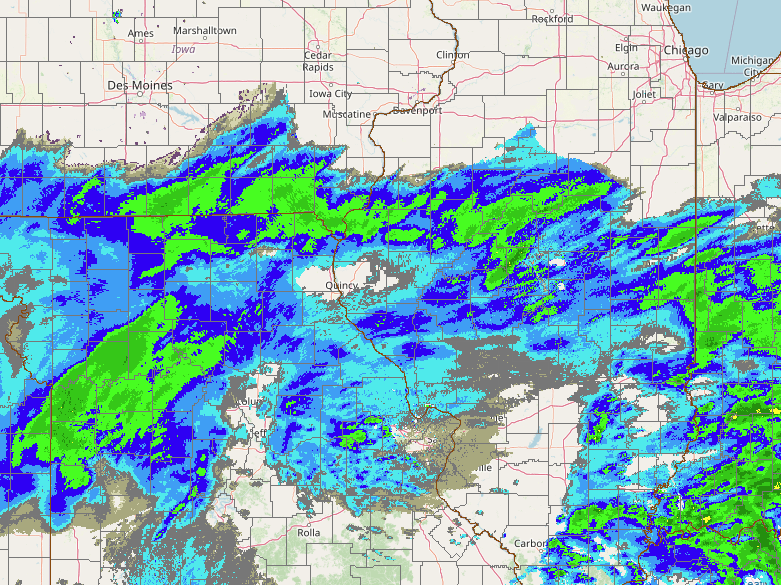
While radar echoes gave the appearance that it was snowing along and north of I-74 throughout the afternoon, the low-level dry layer prevented precipitation from reaching the ground until the atmosphere gradually moistened from the top-down during the evening. Below is a series of radar imagery from January 5th showing how the precipitation evolved. At 6 am (Figure 6), an initial surge of very light snow (red oval) had arrived everywhere south of I-74. By midday (Figure 7), the snow had become heavier and more widespread across central Illinois, but note the large precipitation-free area from Peoria to Bloomington. Finally by 6 pm (Figure 8), the profile had moistened enough to support the development of light snow or flurries at both Peoria and Bloomington.
Snow was the primary precipitation type with this system. However, as the low approached western Kentucky and temperatures warmed aloft, the snow mixed with and changed to sleet and freezing drizzle south of I-70 during the late afternoon and evening. This mitigated snow accumulations a bit across this area, but also added a thin layer of ice. By mid-evening, the low was centered near Bowling Green, Kentucky and a band of light to moderate snow associated with the trough of warm air aloft (TROWAL) pivoting around the low had developed over the Illinois River Valley. This band shifted eastward overnight, then slowly pushed into Indiana by mid-morning January 6th.
 |
 |
|
| Figure 6: 6 am radar image | Figure 7: 6 pm radar image | Figure 8: 6 pm radar image |
 |
Media use of NWS Web News Stories is encouraged! Please acknowledge the NWS as the source of any news information accessed from this site. |
|



 Follow us on X
 Follow us on Facebook
 Follow us on YouTube
 ILX RSS Feed