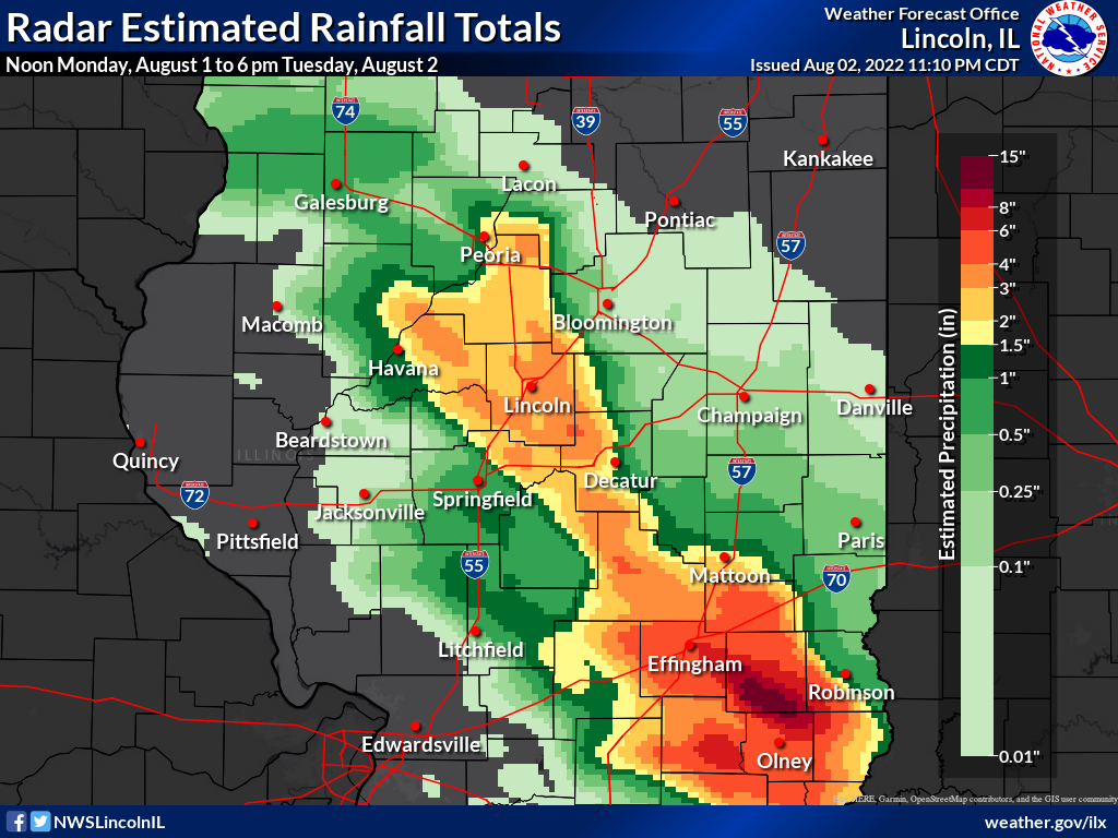
In areas south of I-70, thunderstorms repeatedly began moving over the same areas beginning late afternoon on Monday, August 2. These persisted through the night, and while they weakened for a time early Tuesday morning, additional thunderstorms intensified once again. The heaviest rainfall was estimated by radar to be from 10 to 13 inches across southern Jasper County (dark brown shade on this map north of Olney), though we are not aware of any direct measurements at this time.
Further north, thunderstorms began to arc northwest from the Effingham area during the late night hours, and by sunrise, had nearly reached Peoria. These storms repeatedly moved over the same areas as well. After sunrise, another cluster of strong to severe thunderstorms quickly raced southeast from the Quad Cities, and crossed much of central and southeast Illinois by late morning.
Reports received as of 11 pm Tuesday, August 2:
...36-HOUR PRECIPITATION REPORTS...

Location                     Amount    Time/Date       Lat/Lon
West Liberty                 7.00 in   1040 PM 08/01   38.86N/88.09W
Dundas                       6.93 in   0800 AM 08/02   38.83N/88.09W
Newton                       5.59 in   0345 PM 08/02   38.98N/88.17W
6 E Dundas                   5.50 in   0830 PM 08/01   38.83N/87.98W
Newton                       5.15 in   0345 PM 08/02   38.98N/88.16W
Teutopolis 3.4 SE            4.91 in   0730 AM 08/02   39.10N/88.43W
Blue Mound                   4.70 in   1122 AM 08/02   39.70N/89.12W
1.1 W Newton                 4.61 in   1200 AM 08/02   38.99N/88.18W
East Peoria                  4.10 in   0330 PM 08/02   40.67N/89.58W
Dawson                       4.00 in   0805 AM 08/02   39.86N/89.46W
Teutopolis                   3.86 in   0345 PM 08/02   39.13N/88.48W
1 E Chatham                  3.80 in   0500 PM 08/02   39.67N/89.69W
Washington                   3.65 in   0439 PM 08/02   40.70N/89.41W
Flora                        3.62 in   0340 PM 08/02   38.67N/88.50W
Latham 1.8 SE                3.51 in   1000 AM 08/02   39.95N/89.14W
4 SE Tremont                 3.50 in   1000 AM 08/02   40.48N/89.44W
Peoria Heights               3.45 in   0345 PM 08/02   40.74N/89.58W
2 NE Washington              3.37 in   0933 AM 08/02   40.72N/89.38W
Shelbyville                  3.23 in   1253 PM 08/02   39.41N/88.81W
2 NE Olney                   3.21 in   0800 AM 08/02   38.75N/88.07W
Effingham County Mem Ap      3.20 in   0335 PM 08/02   39.07N/88.53W
Washington                   3.18 in   1251 PM 08/02   40.70N/89.42W
Watson                       3.18 in   1036 PM 08/02   39.03N/88.57W
Olney                        3.05 in   1246 PM 08/02   38.80N/88.12W
Tremont 3.6 E                3.03 in   0850 AM 08/02   40.52N/89.42W
Mackinaw 2NE                 3.03 in   0900 AM 08/02   40.55N/89.33W
Clay City 6 SSE              3.00 in   0600 AM 08/02   38.61N/88.31W
3 W Washington               3.00 in   0953 AM 08/02   40.70N/89.46W
Newton 6.4 NNE               3.00 in   1015 AM 08/02   39.07N/88.11W
Flora Municipal Airport      2.99 in   0700 AM 08/02   38.67N/88.45W
1 SE Flora                   2.97 in   0745 AM 08/02   38.66N/88.48W
Peoria 5 NW                  2.93 in   0800 AM 08/02   40.75N/89.62W
6 NE Lincoln                 2.83 in   0700 AM 08/02   40.21N/89.27W
Chestnut 1.9 W               2.80 in   0700 AM 08/02   40.05N/89.22W
Mount Zion                   2.75 in   1010 AM 08/02   39.78N/88.87W
2 E Shelbyville              2.70 in   0800 AM 08/02   39.41N/88.77W
3 S Alta                     2.64 in   1039 AM 08/02   40.77N/89.64W
Lincoln - Logan County AP    2.64 in   0335 PM 08/02   40.17N/89.33W
2 W Chestnut                 2.60 in   0650 AM 08/02   40.05N/89.22W
1 SE Lawndale                2.60 in   0700 AM 08/02   40.21N/89.27W
Altamont 3.8 SSW             2.58 in   0858 AM 08/02   39.00N/88.77W
Germantown Hills             2.58 in   0346 PM 08/02   40.76N/89.48W
1 NW Harristown              2.56 in   1150 AM 08/02   39.85N/89.09W
2 S Olney                    2.55 in   0600 AM 08/02   38.70N/88.08W
Decatur AP                   2.52 in   0343 PM 08/02   39.83N/88.85W
East Peoria                  2.46 in   1251 PM 08/02   40.69N/89.53W
1 S Alta                     2.41 in   1010 AM 08/02   40.80N/89.63W
Sullivan                     2.41 in   0350 PM 08/02   39.60N/88.71W
1 E West Peoria              2.40 in   1059 AM 08/02   40.70N/89.62W
Washington                   2.40 in   1251 PM 08/02   40.74N/89.42W
Decatur AP                   2.39 in   1254 PM 08/02   39.83N/88.85W
Effingham 2.3 WNW            2.26 in   0900 AM 08/02   39.13N/88.59W
Yale                         2.24 in   0700 AM 08/02   39.12N/88.03W
Tremont 3.6 E                2.20 in   0850 AM 08/02   40.52N/89.42W
Mackinaw 2NE                 2.20 in   0900 AM 08/02   40.55N/89.33W
2 NNW Elwin                  2.14 in   0100 PM 08/02   39.82N/88.97W
Pekin 3.6 SSE                2.10 in   0900 AM 08/02   40.52N/89.60W
NWS Lincoln                  2.06 in   0100 PM 08/02   40.15N/89.34W
Metamora 6.4 W               2.04 in   0800 AM 08/02   40.79N/89.49W
Morton                       2.03 in   1030 AM 08/02   40.61N/89.46W
Sullivan                     2.02 in   0100 PM 08/02   39.60N/88.61W
Pesotum                      2.00 in   0745 AM 08/01   39.91N/88.27W

Observations are collected from a variety of sources with varying
equipment and exposures. We thank all volunteer weather observers
for their dedication. Not all data listed are considered official.