Overview
Intense winds affected central Illinois the weekend of April 2-3. The strongest winds occurred on Saturday, April 2, but gusty winds also occurred on Sunday, April 3.
 |
 |
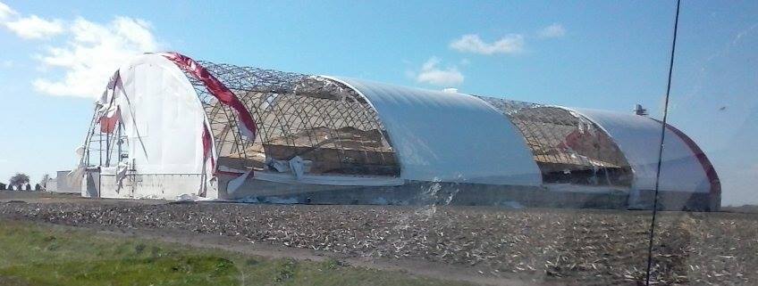 |
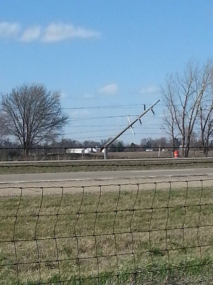
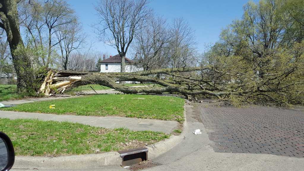
| Rantoul (photos by Rich Lewis) | Urbana (photo by Chris Heater) | Princeville (photo by Darin Kronner) |
Wind Measurements
Saturday's Peak Wind Reports
LOCATION                     SPEED     TIME

3 S Newman                   66 mph     1:30 pm
Springfield (Capital AP)     62 mph    12:02 pm
Mattoon (Coles Co. AP)       61 mph     2:42 pm
Bloomington                  60 mph     3:09 pm
1 W Pekin                    60 mph    12:10 pm
1 W Sidney                   60 mph    12:40 pm
Arcola                       59 mph     2:30 pm
1 NNE Divernon               59 mph     3:25 pm
Jacksonville Airport         59 mph    12:15 pm
Lacon (Marshall Co. Arpt)    59 mph    10:55 am
2 NNE Ashland                58 mph     1:50 pm
Galesburg Airport            58 mph    11:15 am
Lake of the Woods            58 mph    11:15 am
Bloomington (Central IL AP)  57 mph    12:30 pm
Decatur Airport              57 mph    12:50 pm
1 SSE Mahomet                57 mph     1:13 pm
4 S Ellisville               56 mph    10:25 am
Ogden                        56 mph    12:12 pm
Rantoul Nat'l Aviation Ctr   56 mph    12:55 pm
Savoy (Willard Airport)      56 mph    12:51 pm
Danville                     55 mph     2:30 pm
Paris (Edgar Co. Airport)    55 mph     1:55 pm
Pekin                        55 mph     1:00 pm
8 E Petersburg               55 mph     1:15 pm
3 W Bismarck                 54 mph     5:15 pm
South Jacksonville           54 mph     1:10 pm
1 N Tilton                   54 mph     2:01 pm
Peoria Int'l Airport         53 mph    10:54 am
Lawrenceville-Vincennes AP   52 mph     3:46 pm
2 E Mattoon                  52 mph     3:25 pm
Robinson (Crawford Co. AP)   52 mph     3:15 pm
2 SE Urbana                  52 mph    12:30 pm
Charleston                   51 mph     2:10 pm
1 W Havana                   51 mph     2:10 pm
Taylorville Airport          51 mph     2:35 pm
Olney                        50 mph     2:55 pm
Tuscola                      50 mph    12:15 pm
Sunday's Peak Wind Reports
LOCATION SPEED TIME
Lacon                        54 mph    4:10 pm
1 W Havana                   50 mph    5:25 pm
2 W Hopedale                 50 mph    5:25 pm
Bloomington                  49 mph    4:09 pm
1 NNE Divernon               47 mph    4:25 pm
1 W Pekin                    47 mph    5:10 pm
1 SSE Mahomet                46 mph    4:43 pm
Savoy (Willard Airport)      46 mph    4:16 pm
Bloomington (Central IL AP)  45 mph    4:58 pm
Lake of the Woods            45 mph    4:41 pm
1 WSW East Peoria            45 mph    5:10 pm
2 NNE Ashland                44 mph    4:54 pm
1 S Forsyth                  44 mph    3:38 pm
Danville (Vermilion Rgl AP)  44 mph    3:55 pm
Galesburg Airport            44 mph    5:15 pm
2 S Jacksonville             44 mph    4:25 pm
Decatur Airport              43 mph    4:23 pm
Peoria Int'l Airport         43 mph    4:02 pm
Rantoul Nat'l Aviation Ctr   43 mph    2:55 pm
Springfield (Capital AP)     43 mph    5:09 pm
1 W Sidney                   42 mph    4:44 pm
3 NW Champaign               42 mph    5:13 pm
Beardstown                   41 mph    3:10 pm
Jacksonville Airport         41 mph    3:55 pm
Lacon (Marshall Co. AP)      41 mph    4:55 pm
3 W Shelbyville              41 mph    4:12 pm
4 E Waynesville              40 mph    2:41 pm
Damage Reports
Here is a sample of reports we have received. Other damage may have occurred, which was not relayed to our office.
Champaign County:
Christian County:
Douglas County:
Edgar County:
Fulton County:
Logan County:
McLean County:
Macon County:
Marshall County:
Menard County:
Peoria County:
Piatt County:
Sangamon County:
Shelby County:
Tazewell County:
Vermilion County:
Woodford County County:
Photos & Video:
 |
 |
 |
 |
| Blowng dust near Windsor (photo by Everett Lau) |
SE of Paris (photo by Everett Lau) |
Near Lawndale (photo by Kathy Payne) |
Decatur (Photo by Jackie Hayes) |
Environment
The image below, courtesy of the Chicago NWS office, shows the mean sea-level pressure (left) and the 3-hourly pressure change (right), from 2 am to 7 pm on April 2nd. The pressure value of 997 millibars over Milwaukee during the morning is rather low for a springtime "clipper" system, and such deep lows have an inherent stronger wind field due to the change in pressure (referred to as a "pressure gradient"). In addition, the rapid speed of the low's movement (which is common for clippers) produced a high rate of change in pressure values. The highest change in pressure values tracked over northern Illinois, which also saw wind gusts of 50-60 mph (visit https://www.weather.gov/lot/2016apr02_windssnow for more information).
 |
| Image courtesy: National Weather Service, Chicago |
 |
Media use of NWS Web News Stories is encouraged! Please acknowledge the NWS as the source of any news information accessed from this site. |
|

