National Weather Service United States Department of Commerce


3-day snowfall across the Midwest, ending 8 am February 3, 2010
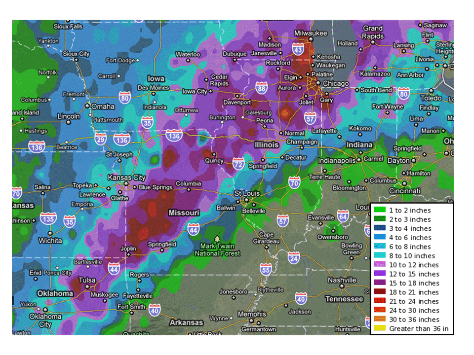
3-day snowfall across the Midwest, ending 8 am Thursday, February 3. Click image to enlarge.
Note:The above graphic provides an overview of snowfall observations taken from official and supplemental sources. 

For official snowfall amounts please see images below.

Quick Links:  Overview, Local Impacts, Snowfall RecordsReported Winds, Observed Totals


A widespread and unusually significant snowstorm affected a large part of the Midwest as February began.  Excessive snowfall totals of a foot were common in a large area from Oklahoma northeast to Michigan (see image above), and were in excess of 2 feet in some areas.  After passage through the Midwest, the storm system moved on to affect New England. Several locations had snowfall approaching or exceeding all-time records.   Blizzard conditions were widespread.


This page focuses on impacts across central and southeast Illinois.  Information for other areas is available at these links:

National watch/warning/advisory map from Tuesday morning
National watch, warning, and advisory map from Tuesday morning, February 1.  Winter storm warnings were in effect from New Mexico to Maine (pink shades); the red shades indicate blizzard warnings, which extended from central Oklahoma to southern Michigan.  (click image to enlarge)

Overview:

Computer models began to latch onto the idea of a major snowstorm about a week in advance, although there was significant differences as to the exact placement.  The models began to converge in their solutions by the weekend of January 29-30, and suggested snowfall in excess of a foot over a large area.  The critical item was determining the exact track of the low, as this would dictate which areas received excessive snowfall, and which areas would see a risk of significant amounts of freezing rain.  By Sunday morning (January 30), winter storm watches were issued over a large part of the Midwest.  In central Illinois, the heavy snow focus was along and west of I-55, while east central Illinois would likely see a mixture of freezing rain, sleet, and snow, keeping overall snow accumulations lower.  Ice accumulations of a quarter to 3/4 inch were forecast for southeast Illinois, along and south of I-70.

Forecast snowfall from NAM model run Tuesday morning
Forecast snowfall from NAM model, from Tuesday morning (12Z) run, from 6 am Tuesday to 6 pm Wednesday.  The heaviest axis of snow, 20" or more, extended from southeast Iowa northeast to Chicago; 15" or more was indicated along and west of the Illinois River.

Forecast snowfall from GFS model, run Tuesday morning
Forecast snowfall from GFS model, from Tuesday morning (12Z) run, for the same period as the NAM model.  The heaviest snow axis was a bit further south, from central Missouri to Chicago, and indicated 15-20" was likely.
 

Forecast temperatures at 850 mb (1500 feet)
Forecast temperatures at 850 mb (approximately 1500 feet above ground level), from NAM model, valid 6 pm Tuesday.  Green shades indicate temperatures above freezing in east central and southeast Illinois, which resulted in more sleet and freezing rain in those areas.


Blizzard warnings were issued in central Illinois, mainly along and west of I-55, by early Monday afternoon, a good 18 to 24 hours before the storm began.  Winter storm warrnings were issued across east central and southeast Illinois.  These warnings were in effect from early Tuesday morning through midday Wednesday.  Model projections from the Tuesday morning model runs are depicted above (click images to enlarge).

The track of the storm system is depicted in the images below (click images to enlarge).

Surface map at 6 pm January 31.
6 pm Monday, January 31

Surface map at 6 am Tuesday, February 1
6 am Tuesday, February 1

Surface map at 6 pm Tuesday, February 1
6 pm Tuesday, February 1

Surface map at 6 am Wednesday, February 2
6 am Wednesday, February 2


Central and Southeast Illinois Impacts:

Snowfall totals of a foot or more were widespread from the I-55 corridor westward into Missouri and Iowa.  Near and west of the Illinois River, totals of 15 to 20 inches were common.  The bulk of the snow fell over a period from mid morning Tuesday (February 1) to early morning Wednesday (February 2).  During the height of the storm Tuesday evening, several thunderstorms were reported, which heightened the snow accumulation even further.  In Peoria, the snow was falling at the rate of 2 to 3 inches in an hour late Tuesday evening due to the thunderstorms.

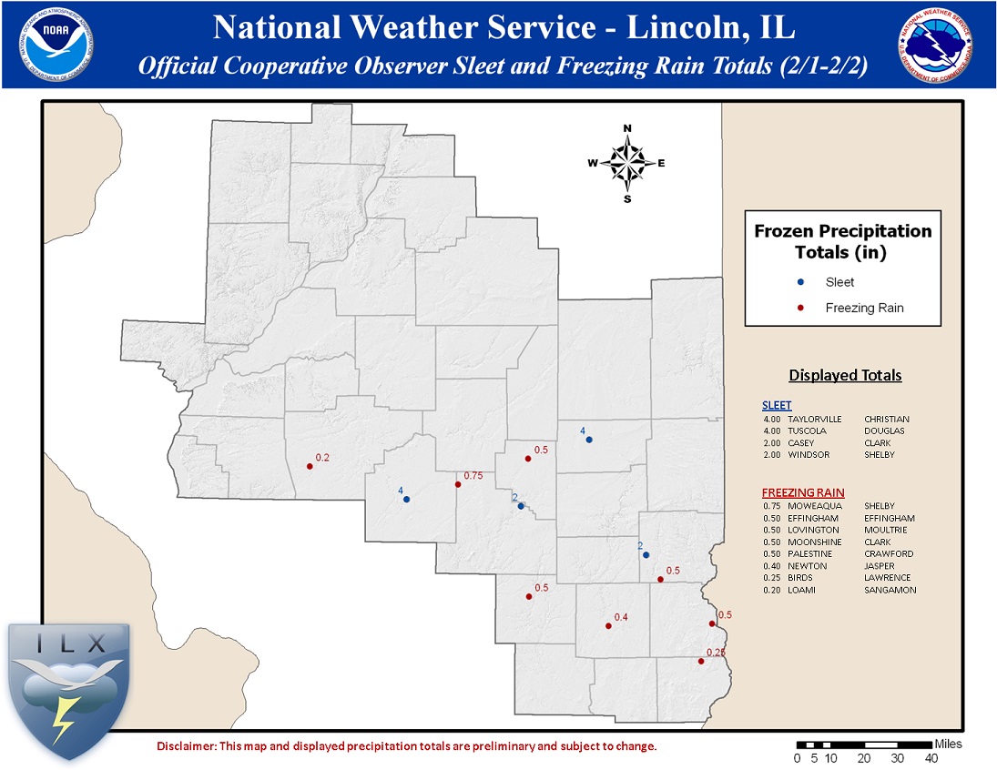
East of I-55, the precipitation quickly transitioned to a mixture of sleet, freezing rain, and snow, due to warm air aloft.  Excessive amounts of sleet were reported in some areas, such as Tuscola and Taylorville (4 inches), as well as Danville (3 inches).  Overall sleet and snow totals in this area ranged from 4 to 7 inches.

In areas closer to the I-70 corridor, freezing rain was the primary precipitation type on Tuesday, with ice accumulating from half to 3/4 of an inch thick.  Many areas reported damage to tree branches and power lines due to the ice.  The ice began to melt during the evening, as surface temperatures rose above freezing with the approach of the parent low.  The snow in this area, which accumulated as cold air spread into the area after midnight Tuesday night, only accumulated an inch or two.

Northeast winds gusted from 45 to 60 mph across much of central Illinois Tuesday afternoon and evening.  As the parent low pressure moved northeast toward west central Indiana late in the evening, the winds shifted around to the northwest, and gusted from 35 to 50 mph the remainder of the night.  Gusts of 35 to 45 mph or higher continued into midday Wednesday.  These winds caused near zero visibility due to blowing snow.  Snowplows had great difficulty keeping up as the roads would drift shut as soon as they were cleared, and in some cases plowing crews were called off the roads Tuesday night until the worst had passed.  Road closures included I-74 between Galesburg and Peoria, all of I-155, and I-39 between Bloomington and Rockford.
 

Snowfall Records:

The following locations in central Illinois established all-time 24-hour snowfall records.  The snowfall totals run from approximately 7 am Tuesday, February 1, through 7 am Wednesday, February 2.  The National Centers for Environmental Information (NCEI) certified these records as official.

Location County Snow Total Old 24-Hour Record
Winchester Scott 18 inches 13 inches (Feb. 28, 1900)
Princeville Peoria 17 inches (tie) 17 inches (Jan. 1, 1999)
Havana Mason 16 inches 14.6 inches (Dec. 1, 2006)
Galesburg Knox 15 inches 11 inches (April 11, 1997)
11 inches (Feb. 18, 1908)
Bradford Stark 15 inches 12 inches (Dec. 1, 2006)
Toulon Stark 14.8 inches 12 inches (Dec. 1, 2006)
Mackinaw Tazewell 13.6 inches 11 inches (Dec. 19, 1973)
Beardstown Cass 13.5 inches 12 inches (Jan. 30, 1939)
Bloomington McLean 13.1 inches 9 inches (Jan. 13, 1964)
Jacksonville Morgan 12 inches (tie) 12 inches (Feb. 28, 1900)
Mason City Mason 10 inches 9 inches (Feb. 1, 2008)


Reported Peak Wind Gusts:

  • Roanoke, Emergency Operations Center -- 64 mph
  • Tremont, Emergency Operations Center -- 56 mph
  • Bloomington, Central Illinois Regional Airport - 53 mph
  • Lincoln, Logan County Airport -- 53 mph
  • Rantoul National Aviation Center -- 52 mph
  • Peoria International Airport -- 52 mph
  • Decatur Airport -- 51 mph
  • Galesburg Municipal Airport -- 51 mph
  • Springfield, Abraham Lincoln Capital Airport -- 48 mph
  • Jacksonville Municipal Airport -- 46 mph 


                                                                                              Official Cooperative Observer
             Official Storm Total Snowfall Map                             Freezing Rain/Sleet Map                      

        Storm total snowfall, based on official weather observations            Storm total snowfall, based on cooperative weather observations
                             (click image to enlarge)                                                   (click image to enlarge)


Official Cooperative Observer Snow Totals
(certified by NCEI)

Mesonet Snow Totals (unofficial data) 
** Denotes NWS-verified observations...consider official

INCHES  LOCATION             COUNTY       
------  -------------------  -----------  
 19.3   ST DAVID              FULTON
 18.5   AVON 5NE              FULTON
 18.0   WINCHESTER            SCOTT
 17.9   PRINCEVILLE 2W        PEORIA
 17.0   GERMANTOWN HILLS      WOODFORD
 16.0   HAVANA                MASON
 16.0   RUSHVILLE             SCHUYLER
 15.9   BRADFORD 3SSE         MARSHALL
 15.4   TOULON                STARK
 15.0   GALESBURG             KNOX
 15.0   PEORIA                PEORIA
 14.8   KNOXVILLE             KNOX
 14.4   MORTON                TAZEWELL
 14.3   MACKINAW 1N           TAZEWELL
 14.2   CAMP GROVE 2SW        STARK
 13.6   BEARDSTOWN            CASS
 13.3   DAHINDA               KNOX
 13.1   BLOOMINGTON WTRWKS    MCLEAN
 13.0   BLOOMINGTON 5W        MCLEAN
 13.0   CHENOA                MCLEAN
 13.0   LAKE SPRINGFIELD      SANGAMON
 13.0   NORMAL 4NE            MCLEAN
 12.5   STANFORD 2S           MCLEAN
 12.0   JACKSONVILLE 2E       MORGAN
 12.0   ROANOKE               WOODFORD
 12.0   LINCOLN NWS           LOGAN
 12.0   SHERMAN               SANGAMON
 11.6   SPRINGFIELD 2         SANGAMON
 10.4   JACKSONVILLE 2        MORGAN
 10.0   MASON CITY 2N         MASON
  9.3   MOUNT PULASKI         LOGAN
  8.4   KINCAID               CHRISTIAN
  8.2   FISHER                CHAMPAIGN
  8.0   FARMER CITY 3W        DE WITT
  8.0   SAYBROOK              MCLEAN
  7.0   DECATUR               MACON
  7.0   HOOPESTON 1NE         VERMILION
  6.9   URBANA                CHAMPAIGN
  6.0   TUSCOLA               DOUGLAS
  5.8   OGDEN                 CHAMPAIGN
  4.0   SHELBYVILLE DAM       SHELBY
  4.0   TAYLORVILLE 2SW       CHRISTIAN
  3.0   LOVINGTON             MOULTRIE
  3.0   PANA 3E               SHELBY
  2.0   WINDSOR               SHELBY
  2.0   CASEY                 CLARK
  1.5   EFFINGHAM             EFFINGHAM

  1.5   NEWTON 1W             JASPER
  0.4   ROBINSON              CRAWFORD

 INCHES  LOCATION             COUNTY   
------  -------------------  ---------
 20.0   1 N ABINGDON         KNOX     
 15.6   BRYANT               FULTON   

 15.2** 1 SW JEROME          SANGAMON 
 15.0   2 SSE PEORIA         PEORIA
 14.7   HOPEWELL             MARSHALL
 14.5   GERMANTOWN HILLS     WOODFORD
 14.0   HENRY                MARSHALL 
 14.0   7 W PETERSBURG       MENARD 
 13.5   5 W SPRINGFIELD      SANGAMON  
 13.0   5 W BLOOMINGTON      MCLEAN 
 13.0   GRIDLEY              MCLEAN  
 13.0   2 SW PEORIA          MCLEAN
 12.5   1 S MOSSVILLE        PEORIA   
 12.0   CHATHAM              SANGAMON 
 12.0   MANITO               MASON    
 12.0   LINCOLN              LOGAN    
 12.0   4 NE NORMAL          MCLEAN   
 12.0   ARROWSMITH           MCLEAN
 11.9   2 ESE NORMAL         MCLEAN   
 11.7   3 SW BLOOMINGTON     MCLEAN
 11.5** FRANKLIN             MORGAN
 11.5   1 SSE MORTON         TAZEWELL
 11.0   ELLISVILLE           FULTON  
 11.0   5 W LINCOLN          LOGAN
 11.0   1 NNW PEKIN          TAZEWELL
 10.5   1 NNW LINCOLN        LOGAN
 10.4   4 SW BEASON          LOGAN 
 10.0   1 SE LINCOLN         LOGAN
 10.0   4 SSW LE ROY         MCLEAN
  9.5   1 E HEYWORTH         MCLEAN
  9.4   7 W ATLANTA          LOGAN
  9.0   1 S OREANA           MACON    
  8.5   1 SW ROCHESTER       SANGAMON
  8.0   2 WSW CHAMPAIGN      CHAMPAIGN
  7.0   1 NNE MAHOMET        CHAMPAIGN
  6.0   1 SSW CHAMPAIGN      CHAMPAIGN
  5.0   AUBURN               SANGAMON 
  4.2   2 N HOMER            CHAMPAIGN
  3.0** MATTOON              COLES
  1.5** NEOGA                CUMBERLAND


Official Cooperative Observer Sleet and Freezing Rain Totals
(preliminary data, subject to certification)

Mesonet Freezing Rain Totals
(unofficial data)

Sleet Totals:

INCHES  LOCATION             COUNTY       
------  -------------------  ----------- 
  4.00   TUSCOLA              DOUGLAS   
  4.00   2 SW TAYLORVILLE     CHRISTIAN  
  2.00   CASEY                CLARK     
  2.00   WINDSOR              SHELBY
  1.20   OGDEN                CHAMPAIGN


Sleet Totals:

INCHES  LOCATION             COUNTY       
------  -------------------  ----------- 
  4.20   CHAMPAIGN            CHAMAPAIGN
  4.00   2 S DECATUR          MACON
  4.00   3 S NEWMAN           DOUGLAS
  3.00   DANVILLE             VERMILION
  2.50   MATTOON              COLES
  2.00   2 N HOMER            CHAMPAIGN   
  0.75   CHARLESTON           COLES
  0.50   SHELBYVILLE          SHELBY
  0.40   WATSON               EFFINGHAM 

Freezing Rain Totals:

INCHES  LOCATION             COUNTY        
------  -------------------  ----------- 

  0.75   2 S MOWEAQUA         SHELBY
  0.50   EFFINGHAM            EFFINGHAM   
  0.50   MOONSHINE            CLARK       
  0.50   LOVINGTON            MOULTRIE
  0.50   PALESTINE            CRAWFORD    
  0.40   NEWTON               JASPER      
  0.25   2 E BIRDS            LAWRENCE
  0.20   LOAMI                SANGAMON   


Freezing Rain Totals:

INCHES  LOCATION             COUNTY        
------  -------------------  ----------- 

  0.60   CHARLESTON           COLES
  0.60   EFFINGHAM            EFFINGHAM
  0.50   FLORA                CLAY 
  0.40   AUBURN               SANGAMON       
  0.30   LANE                 DE WITT
  0.30   NEOGA                CUMBERLAND
  0.30   OLNEY                RICHLAND
  0.30   PANA                 CHRISTIAN

  0.30   ROBINSON             CRAWFORD
  0.20   MACON                MACON
  0.20   MOUNT ZION           MACON
  0.20   SULLIVAN             MOULTRIE
  0.20   TAYLORVILLE          CHRISTIAN    
  0.10   NEWMAN               DOUGLAS      
  0.12   CHATHAM              SANGAMON