Wilmington, OH
Weather Forecast Office

|
|
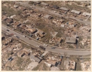
These aerial photographs were provided to NWS Wilmington, Ohio by Attila Kilinc and are used with permission. The images depict the damage caused in Xenia and Wilberforce by the F5 tornado of April 3, 1974. Most of the images have been matched to lat/lon coordinates. Click each thumbnail to view the full-size version (1500 x 1000 px).

|

|

|

|

|

|

|

|

|

|

|

|

n/a
|

n/a
|

|

|

|

n/a
|

|

|

|

|

|

|

|

|

|

|

|

|

|

|

|

|

|

|
The following aerial photographs, provided by Wright-Patterson AFB and obtained through the NOAA Photo Library, show the extent of damage along the 32-mile path of the 1974 Xenia F5 tornado. This monster tornado first touched down southwest of Xenia, inflicting catastrophic damage to the Windsor Park and Arrowhead subdivisions. It then tracked northeast through the city of Xenia and continued on its way through Central State and Wilberforce, where it finally dissipated. Click each thumbnail to view the full-size version (1500 x 1200 px).
 |
 |
 |
 |
 |
 |
 |
 |
 |
 |
 |
 |
 |
 |
 |
 |
 |
 |
 |
 |
 |
 |
 |
 |
 |
 |
 |
 |
FORECASTS
Hourly Weather Graph
Graphical Forecast
Area Forecast Graphics
Area Forecast Discussion
River Forecasts and Obs
WEATHER HISTORY
Past Observed Weather
Local Climate Graphs
Local Event Summaries
OH / ILN Tornado Climatology
This Day in Weather History
NATIONAL CENTERS
Storm Prediction Center
National Hurricane Center
Weather Prediction Center
Aviation Weather Center
Climate Prediction Center
NCEI
US Dept of Commerce
National Oceanic and Atmospheric Administration
National Weather Service
Wilmington, OH
1901 South State Route 134
Wilmington, OH 45177
937-383-0031
Comments? Questions? Please Contact Us.

