|
The Anderson Hills Tornado
In the warm, humid late afternoon hours of May 18, 1995, a tornado touched down just northwest of Athens. It tracked from that point through eastern Limestone County, through Harvest, Meridianville, and New Market in northern Madison County, and ended near Princeton in northwest Jackson County. The strongest portion of the tornado's path was near Harvest in northwest Madison County around the Anderson Hills subdivision and the Huntsville Dragway, which is the reason it is usually referred to as the "Anderson Hills Tornado". The track maps below are only intended to represent the approximate track of the tornado and are not intended to be an accurate representation of the width of the damage path. At several points, the tornado was wider than paths drawn on these maps, and at several other points, the path was considerably smaller.
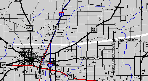
The tornado first touched down at 5:33 PM approximately three miles northwest of Athens, just east of Alabama Highway 99. The tornado moved across Alabama Highway 127, then across I-65 near the interchange with US Highway 31. From there, the tornado strengthened as it continued east, crossing Alabama Highway 251, where it destroyed 13 mobile homes at the Oakdale Mobile Home Park. Here a person received major injuries from the tornado and died later; this was the only human fatality caused by the storm. Around this time, a Tornado Warning was issued for Madison County to give residents on the northwest side of the county an opportunity to take cover; tornado sirens were activated at 5:43 PM, one minute after the warning was issued. Meanwhile, the tornado began to move slightly north of east, moving across Mooresville Road and crossing through the Copeland community near the intersection of Copeland Road and East Limestone Road. It continued to strengthen as it crossed over Limestone Creek and approached the Madison County line. Overall in Limestone County, 35 buildings were damaged or destroyed, and 26 mobile homes were destroyed. Around 9,500 customers lost electricity in the county, where damage was estimated to be $1.5 million. Aside from the aforementioned human fatility, one cow died when a large tree fell on it.
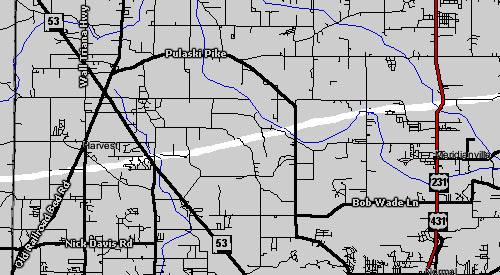
The tornado crossed into Madison County around 5:50 PM on Love Branch Road, just north of the Yarborough Road intersection. It continued an east-northeasterly path across Carroll Road, Old Railroad Bed Road, and Wall Triana Highway, crossing just south of Harvest Elementary School. At 5:52 PM, Madison County Fire dispatch reported that the tornado was on the ground near Harvest. It crossed Fords Chapel Road before taking a direct hit on the Anderson Hills subdivision along Alabama Highway 53. At this point, the tornado was at F4 intensity and the subsequent survey would also reveal evidence of it having multiple vortices. A total of 39 well-constructed houses in the subdivision sustained major damage, and 21 were destroyed. The Piggly Wiggly along Highway 53 also received damage. At 5:54 PM, the Madison County Sheriff's Department confirmed the tornado had crossed Old Railroad Bed Road and Alabama Highway 53. As a result of these reports, tornado sirens were reactivated in Madison County one minute later. The tornado continued east-northeast making a glancing blow to the Huntsville Dragway before crossing Quarter Mountain Road and Bollweevil Lane on the northern face of Quarter Mountain. Next it crossed Hammond Lane (where is caused major damage to a few two story brick homes), Beaver Dam Road, Beaverdam Creek, and Pulaski Pike. It moved over Beaverdam Creek a second time at Mount Lebanon Road as it moved into the Meridianville area, then across Patterson Lane. Shortly after 6:00 PM, the tornado crossed US Highway 231/431 at Steger Curve - around Brier Fork bridge. Here, substantial damage was done to a cotton gin and a large farm house was spun off its foundation.

From the highway, the tornado continued slightly north of east, tracking basically along Steger Road to near its intersection with McCollum Road. It moved across farmland, then crossed Moores Mill Road just south of Moores Mill School (now known as Lynn Fanning School). Several windows at the school were shattered. East of here, the tornado caused damage on the south end of the Timberwinds subdivision before crossing the Flint River between Meridianville and New Market. At 6:13 PM, a Madison County Sheriff's deputy radioed that the tornado was passing over his car on Butler Road. Also at this time, a Tornado Warning was issued for Jackson County. The tornado continued east of here causing structural damage along Arnold Road and Noles Drive before crossing Mountain Fork. It then moved across Sharon Johnson Park, causing mostly tree and minor sturctural damage before crossing Winchester Road in New Market. At this point, the tornado path became more easterly
|


 Local Radar
 Weather Map