|
A Look Back at the Floods of March 1973
Flooding along Huntsville Spring Branch and Memorial Parkway on March 16, 1973. Image from USGS/NOAA report "Floods of March-April 1973 in Southeastern United States," taken by Dudley Campbell, the Huntsville Times. Click image for full size. In the middle of March 1973, the Tennessee Valley region experienced one of its costliest floods in modern history. Heavy rainfall caused flash flooding beginning in the evening hours of Thursday, March 15th in northwest Alabama lasting through the early morning hours of Friday, March 16th across the remainder of north Alabama and in southern middle Tennessee. Flash flooding problems then translated into flooding along area rivers as the rainwater filtered through smaller creeks and streams into larger waterways. As of early 2009, this event still stands as the record flood along many area rivers including the Paint Rock River at Woodville, Limestone Creek at Capshaw, Indian Creek at Madison, Big Nance Creek at Courtland. It also set the record for the maximum streamflow on the Tennessee River at Florence. Several roads and bridges were washed out across the area. There was one death in Lawrence County, when I man drove into the flooding Big Nance Creek near Moulton. Another man who was in the car with him was able to escape the rushing waters with his life. Though this review will focus on impacts in north Alabama and southeastern middle Tennessee, it should be noted that there were major problems over a much larger area. In terms of larger cities, Chattanooga was the location hardest hit by this flood - particularly the Brainerd area where massive flooding occurred along South Chickamauga Creek. The swollen creek actually flooded the Chattanooga Airport. The Tennessee River crested at 10 feet above flood stage in the city. Damage topped $35 million, with hundreds of homes and businesses flooded. More than 300 families from the city were evacuated from their homes. Some reports indicate one-fifth of the city was underwater during the flood’s peak. Jasper and Marion County were also hard hit. National Guard helicopters rescued several citizens in that area. In Columbia, Tennessee, as many as 300 families were evacuated because of flooding along the Duck River. Flooding forced several families from their homes in Knoxville. Travel was also discouraged in the Smoky Mountains between Knoxville and Asheville, North Carolina because several landslides occurred in those areas.
March 1973 got off to an unseasonably warm start, with high temperatures at the Huntsville Airport in the mid 70s on several days. Temperatures were 10 or more degrees above normal on 13 of the first 15 days of the month. The month also got off to a wet start. Through the first 11 days, 2.63? of rain fell, which put the city at 0.65? above the normal (at that time) for the month to date. On Tuesday, March 13th, the upper level pattern featured a longwave trough over the western United States and ridging over the eastern United States. Ahead of the upper trough, lee side cyclogenesis was occurring over the Great Plains. A warm front extended from the developing system generally along the Gulf Coast. By Wednesday morning, the upper trough had taken on a more negative tilt, and a closed height center had developed over the upper Plains. The surface cyclone occluded under the upper low over Nebraska. The warm front had already pushed north through the Tennessee Valley area, placing the region in the warm sector of the system. The associated cold front now extended from the mid-Mississippi River Valley southwestward along the Texas coast. With the surface low occluding, forward progress of the cold front was slow. Isolated showers and thunderstorms affected the area during the morning and afternoon hours Wednesday. However, by the evening hours, widespread showers and thunderstorms moved into northwest Alabama ahead of the slow-moving front. The upper low opened and progressed northeastward as a shortwave through the day Wednesday and was situated near the Great Lakes region by Thursday morning, the 15th. The long wave trough axis was now centered over the middle section of the country. Though the upper ridge axis had shifted a bit to the east, it had only moved slightly over the Atlantic Ocean. This is important to note. Generally speaking, the upper level pattern was not very progressive. Consequently, the approaching frontal boundary stalled. On Thursday morning, it was situated from near Jackson, Mississippi to near Nashville, Tennessee, with most of the north Alabama/south Tennessee area remaining in the warm sector. Showers and thunderstorms, heavy at times, lasted through much of the day across the entire area. Rainfall totals of 2 to 4 inches were common across the region. Thursday afternoon, a surface low developed over the northwestern Gulf of America and tracked along the stationary front. What had been a steady, moderate rain throughout much of the day Thursday became a torrential downpour overnight Thursday into early Friday as the surface low moved past the area. Between 3am and 8am, 3.37? of rain fell at Huntsville International Airport. Before all was said and done, 5.24? had collected in the rain gauge at Huntsville International Airport on Friday. Most of the flooding problems did not begin until the heavier rain reached northwest Alabama Thursday night. The problems spread eastward overnight as the axis of heavier rain moved east. Finally, the longwave upper trough made substantial eastward progress on Friday, kicking the surface system out of the area by Friday evening and ending the precipitation.
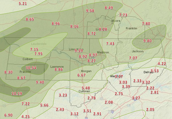
The area of maximum storm-total rainfall from this system was situated along a southwest to northeast axis directly on top of the Tennessee Valley area. This will help to explain the long list of problems described below in the Flood Impacts section. The highest rainfall total from Wednesday through Friday was 10.54? at Russellville in Franklin County, Alabama. There were additional reports of 10+" of rain in northeastern Mississippi. Generally, areas south of the Tennessee River Divide received much lower rainfall totals. Less than four inches of rain fell over southern Cullman, southern Marshall, and southern Dekalb counties. The rainfall accumulation map below illustrates the area where the heaviest rain fell.
Rainfall Totals from Wednesday, March 14th through Friday, March 16th.
There were significant problems from both flash flooding and river flooding. Of course, flash flooding was the first problem that arose. Practically every branch, creek, and small stream under the axis of heaviest rainfall in the Tennessee River Valley quickly rose to flood Thursday night and early Friday morning. Eventually, runoff filtered into larger streams and rivers. River flooding lasted through the weekend, especially on the main stem of the Tennessee River.
Long stretches of Memorial Parkway were under water, and several motorists had to be rescued by boat. According to the Huntsville Times, the Army's Missile Command supplied boats for evacuation and dozens of Huntsville residents also volunteered their own boats. Among the businesses hard hit in Huntsville were Royal Chevrolet (formerly located at the intersection of Pratt Avenue and Washington Street - along Pinhook Creek), Lee-Bentley Chrysler-Plymouth, Brant's Women's World (at Memorial Parkway and Governors Drive - along Huntsville Spring Branch), the Sand's Motel, the Frank-Ann Motel (at Memorial Parkway and Governors Drive), Foto Mart, and Plamore Bowling Lanes. The Chevrolet dealership had 149 new automobiles and seventeen used cars damaged. The Lee-Bentley dealership lost over 60 new automobiles and one used car. South Central Bell Telephone Company's operations in Huntsville were hampered by the flooding. Their fleet of repair trucks, about 75 in total, were under water. They were trying to supply equipment to Huntsville Utilities. Huntsville Utilities also had problems deploying trucks due to flood waters surrounding their offices. Though no serious injuries were reported in Huntsville, Huntsville Hospital reported a few patients with slight injuries. Whiteway Trailer Park was evacuated as water filled the area. University Drive was closed, with water covering the road at Rideout Road (now Research Park Blvd). One and a half feet of water flooded Councill School on Pelham Avenue. The flood waters along Memorial Parkway poured into the basement of the Huntsville Times. Because the black ink storage and main ink pumps used to print the paper were located in the basement, the paper was forced to use blue ink and backup color ink pumps, normally reserved for advertisements and special displays. As a result, the Huntsville Times was printed in blue on Friday the 16th. Only one edition was printed that day.
As high volumes of water from various tributaries filtered into the Tennessee River, it rose significantly. Not only did residents have to worry about the rain that fell over north Alabama. Heavy rains that occurred farther upstream between Chattanooga and Knoxville caused rises upstream that had to flow through north Alabama. Redstone Arsenal was virtually cut in half by flood waters. Water was so high on the Tennessee River at the Whitesburg Bridge that sightseers lined up along Memorial Parkway to witness the swollen river first hand. At times, traffic was backed up as much as two miles in the southbond lanes. Some people pulled off along the side of the highway to take pictures; others just observed from the narrow two-lane bridge spans. The parking lot of the GTE Automatic Electric facility was filled with spectators. There was a similar scene along Green Cove Road, where Aldridge Creek was covering the road. Elsewhere around the county, water was reported over US 72 just east of Gurley. Indian Creek reached its highest crest at the river gauge on Highway 20. Undoubtably, water covered the Old Madison Pike bridge. According to the USGS, streamflow on Indian Creek reached a rate of 9.1 billion gallons a day! Peak flow on Indian Creek was more than twice the previous record flood. The town of Triana, located at the confluence of Indian Creek and the Tennessee River, was almost completely under water. There was extensive damage to buildings there. USGS, COE, and TVA surveys revealed flooding also occurred along Walker Branch near Plevna, Morris Branch near Toney, Dallas Branch in Downtown Huntsville, Fagan Creek in Huntsville, and McDonald Creek in west Huntsville. Total damage throughout the county was estimated to be over $8 million. In Lauderdale County, widespread flooding took place around the city of Florence. Several basements in the city were flooded. Flooding of farms and roads along Cypress Creek and its various tributaries was extensive, especially in the town of Cloverdale. Cattle had to be rescued along the creek, and many cattled were believed to have drowned. Considerable flooding occurred on Shoal Creek. Six mobile homes were demolished in the Goose Shoals area in northern Lauderdale County between Zip City and Greenhill. Debris from the homes were left hanging in nearby trees. Flood surveys revealed additional flooding along Anderson Creek near Lexington. Water slowly rose along the Tennessee River to historic levels. The river reached its highest stage in history at Florence, topping a record set in 1897 (before flood control operations began along the river). Along the river, McFarland Bottom Park and the old State Docks were under water. The Pro Shop at McFarland Park was flooded and fences around it floated away. Water flooded the railroad bridges and was up the metal truss under the O'Neal Bridge. Highway 20 was flooded, forcing it’s closure. The road over Wilson Dam was closed because of a large hole that developed in the pavement, believed to be caused by the rain. Elsewhere around the county, portions of US 72 were closed. A mudslide blocked Waterloo Road. Five roads sustained bridge damage throughout the county, including CR 8 in the western part of the county, CR 17 near Stewartsville, CR 10 just west of Salem Church, and Highway 39 near Greenhill. Colbert County was also hard hit by flooding. In Tuscumbia, severe flooding occurred along Spring Creek. The city’s water pump in Spring Park was under 6 to 7 feet of water. Because of this, residents temporarily received drinking water from the city of Sheffield. Several homes around the park flooded. Flood waters covered 12 city blocks and damaged 34 homes in the city. Westside Baptist Church was flooded. In Sheffield, there was flooding around the WVNA radio transmitter, which was reported to be under two feet of water. The Liberty Supermarket was surrounded by water. Some people were stranded in the Bethel community in the southeast corner of the county, perhaps along Town Creek. Portions of US 43 and Old US 43 were closed between Florence and Russellville. Portions of US 72 were closed, and the Little Bear Creek bridge in the western part of the county was completely under water at one point. Parts of Highway 247 were closed in the western part of the county. Flood surveys revealed additional flooding on Bear Creek near Bishop in the far western part of the county. The rising Tennessee River backed up Pond Creek which drains much of the city of Muscle Shoals and flows through the TVA Reservation. 70 businesses and dozens of homes were flooded in the city. Knee-deep water coming from the TVA Reservation flowed 200 yards wide across 2nd Street (AL Highway 184) in two different places. Flood waters entered the FAME Recording Studio building. Water at the Green Acres Mobile Home Park was reported to be as high as the doorknobs of some units, and it inundated several cars. Flood waters also surrounded several stores at the SouthGate Mall. During the peak of the flooding, the Florence Times/Tri-Cities Daily made arrangements to fly newspapers by plane to some flood-stricken areas that could not be reached by vehicle. In Franklin County Alabama, a bridge was washed out on County Road 8 near Dismal Falls. Flood waters forced the closer of portions of US 43, Old US 43, Highway 24 between Russellville and Red Bay, and Highway 247 in the western part of the county. Flood surveys revealed river flooding along Bear Creek near Posey Mill (southeastern part of the county) and near Red Bay, on Cedar Creek near Pleasant Grove, and on Little Bear Creek near Halltown. In Lawrence County, a man died when his car was washed away by a swollen Big Nance Creek. The man, whose father was a Sheffield police lieutenant, was driving with another man on Little Sam Road north of Courtland. A major flood occurred on the creek, and this event was the record crest at the Courtland river gauge. Big Nance Creek also forced the evacuation of Courtland Hospital. 14 inches of water entered the building. Flood surveys revealed additional flooding along West Flint Creek near Oakville, Almon Branch near Moulton, Crow Branch near Moulton, and Eddy Creek near Moulton. Significant flooding occurred on the Tennessee River. The Fisherman’s resort on Highway 101 a mile south of Wheeler Dam was flooded with water up to the windows. The houseboats, pontoon boats, and fishing boats at the marina broke loose as the piers washed away. The boats scattered down the river in the direction of Wilson Dam, some losing motors along the way. In Morgan County, a woman narrowly escaped injury on the evening of the 15th. Around 8pm, her car was washed into a culvert between Sherman Street and Jackson Street in northeast Decatur. According to police, water was at “head level” and pouring in to her car as she was rescued. Rising waters along Spring Branch and Flint Creek forced evacuations along Country Club Road in southeast Decatur. As the Rescue Squad reached houses in that area, water had already reached door levels. Additional problems were reported along Spring Branch. US 31 was impassible at times near Southland Plaza. Also, much of the Gateway Shopping Center parking lot was under water. On the southwest side of town, a man was stranded in a phone booth on Austinville-Flint Road and had to be rescued. Several streets in the city of Decatur were damaged, including 6th Avenue. Extensive damage occurred in rural areas of the county. In Hartselle, the Grove Bridge on the south side of town was washed away. There was also extensive damage in Falkville. Many creeks overflowed in eastern sections of the county. Lacey’s Spring, Cotaco, Talucah, and Valhermoso Springs were the hardest hit areas of the county. Flood surveys revealed flooding along Cotaco Creek near Florette, on Flint Creek in Falkville, on Town Branch near Hartselle, and on Shoal Creek near Hartselle. Major flooding on the Tennessee River had a big impact on Decatur and Morgan County. It was reported to be the worst flooding in Decatur since 1867. Water from the Tennessee River forced several families to evacuate their homes. The Point Mallard Golf Course was completely flooded, and flood waters approached the park’s wave pool. In Limestone County, Town Creek flooded much of the downtown area, creating a “three-block wide lake” as the Huntsville Times’ Bob Dunnavant described it. Among the businesses affected by flood waters were a shopping center, a savings and loan association, and a new car dealership. Reportedly, several hundred Athens residents were evacuated from their homes as water to a depth of two to three feet deep flooded residential areas of town. Some had to be rescued by boat by the Athens-Limestone Rescue Squad. Portions of US 31 and US 72 were covered by as much as two feet of water, and several Athens city streets were under water. As much as three feet of water surrounded the Con Agra Poultry company that Friday. Flood problems were also reported along Swan Creek. Record flooding also occurred on Limestone Creek from Capshaw downstream through the Mooresville area. Peak flows were more than double the flows of the previous record flood at the location. Flood surveys revealed additional flooding along Vinson Branch near Athens, Johnson Branch near Athens, and Sugar Creek near Good Springs. Piney Creek covered Highway 20 near Mooresville. A 22 year old Decatur man attempted to cross the swiftly-flowing current in his two and a half ton truck. The truck was pushed off the shoulder into a ditch filled with about 35 feet of water. He was able to escape from the cab, but was washed about 50 yards into a group of trees. After several hours, a Redstone Arsenal Army captain, with the help of five other men, saved the man. Several bridges were washed out as well on Friday, including the Townsend Ford Road over Big Creek near Cartwright, a bridge on Segers Road east of Belle Mina, and another bridge near Capshaw. Several roads were damaged, with ruts cut through the pavement at around a dozen locations throughout the county. Road damage alone was estimated at a million dollars. Major flooding occurred on the Elk River. Several hundred head of livestock reportedly drowned in low areas along the river. Flood waters from the river flooded Alabama Highway 99 near Marbut’s curve. In Jackson County, flash flooding occurred along several small creeks and streams, including Widows Creek, Williams Creek, Mud Creek, Robinson Creek, and Crow Creek. A total of twelve bridges were washed out around the county, including bridges on County Roads 3, 75, 20, 145, 93, and 89. Several other roads were also damaged including County Roads 1, 4, 30, 11, 13, 33, 42, 35, 53, 54, 148, 91, and 89. Alabama Highways 65 and 117 had to be closed at times, and US 72 had to be closed at times. One lane was washed out on AL Highway 146, and one lane was washed out on US 72 East. Water also covered US 72 between Stevenson and Bridgeport, and part of the roadway at the location was washed out. Road damage throughout the county was estimated to be in the “millions of dollars”. Major flooding took place in the Paint Rock Valley, and the Paint Rock River reached its highest crest ever at the US 72 bridge near Woodville. Water rose to the top of the bridge, and for a short period of time, authorities were concerned the rushing water would tear out the bridge. Some cracks were found on the bridge, but it remained in tact. However, large trucks were prohibited from using the bridge until further inspections could be completed. Farther upstream, nine families in the Princeton area were evacuated. Washed out bridges and roadbeds made it difficult for rescuers and relief efforts to reach some homes in the river valley. A Huntsville Times writer noted, “As one passes through communities like Trenton, Hollytree, and Princeton, you cringe at the devastation.” The Tennessee River also caused major problems in Jackson County. Heavy rainfall and flooding upstream forced TVA to release water from both Chickamauga Dam and Nickajack Dam, even though levels were already high on Lake Guntersville. Around 15 to 18 familes in the Bridgeport area were evacuated, and as many as 25 additional families in the area were threatened by rising water. Up to a foot of water covered Clemons Road near Scottsboro, isolating the Lakeside subdivision. Marshall County was impacted by flooding along the Paint Rock River and the Tennessee River. Levels on the Paint Rock reached record highs. On the Tennessee River, Lake Guntersville overflowed its banks in several places. Most boat piers were under water. According to TVA, there was a record 11,000 visitors at Guntersville Dam that Sunday, as sight-seers came to view the large volume of water rushing through the dam’s turbines. The road on the south side of the dam was covered by flood waters from nearby Shoal Creek. In Dekalb County, a flash flood at Bucks Pocket State Park stranded fifteen people, including the park manager, his son, and 13 campers from Birmingham. Bucks Pocket is one of the most dangerous locations for flash flooding in this area. The park is basically in a small canyon, which South Sauty Creek and Little Sauty Creek drain through to reach Lake Guntersville. When large amounts of runoff occur during heavy rains, the creek levels rise quickly due to the steeper, narrower channels in the “pocket”. It’s this type of quick rise that really brings the “flash” in “flash flood” to life. In Cullman County, heavy rains earlier in the week lead to flash flooding. This caused the closing of a bridge in the River Bend community near Hanceville on March 10th. Dirt at one end of the bridge washed away during heavy rain. On Thursday afternoon, the 15th, heavy rains caused flash flooding in some areas, including downtown Cullman near the Cullman Shopping Center. As flood waters filtered into area rivers and lakes, Smith Lake rose out of its banks, flooding several roads in the Trimble area. Flooding persisted over the weekend. Cottages and cabins along the lake sustained heavy flooding. Several mobile homes were either covered by water or were left floating in it. As much as a foot and a half of water covered Trimble Road, causing it to be closed to traffic. In southern Tennessee, more than 50 families were evacuated from their homes in Fayetteville as the Elk River rose and covered low-lying areas around the city. According to the USGS, the magnitude of the flooding in the Elk River Basin was among the worst in the entire region during this flood event. Levels on the Elk River reached the major flood category and rose to heights never experience before - even surpassing the previous record flood which occurred in 1842. The river was so high water went over the US 231 bridge on the south side of town. The police department, rescue squad, national guardsmen, and volunteers worked much of the day Friday helping people escape rising water. Problems were just limited to Fayetteville, though. There was flooding along all of the Elk River, from Limestone County, northeastward though Lincoln, Moore, and into Franklin County. Tims Ford and the Woods Reservior were overwhelmed with water.Despite the fact that considerable flooding was already taking place in the city of Fayetteville, water had to be released from both reserviors to relieve stress farther upstream. Still, according to the USGS, the majority of the flood crest in Fayetteville was caused by water collected in the drainage basin downstream of Tims Ford - not by water released from it. Flood damage in Fayetteville alone was estimated to be over a million dollars. Surveys by USGS, TVA, and the COE revealed additional river and stream flooding along Big Huckleberry Creek near Belvidere, in the area of the Elk River Dam at the Woods Reservior near Estill Springs, on the West Fork of Mulberry Creek near Mulberry, along the East Fork of Mulberry Creek in Lynchburg, on Chicken Creek at McBurg, and on Norris Creek and its tributaries between Fayetteville and Belleville.
Do you have memories from the March 1973 flood? If you have stories or photos from the storm that you're willing to share with us, we'd love to hear from you! For more information on how to contact us, visit this page. |


 Local Radar
 Weather Map