
A cold front will cross the Great Lakes and Northeast U.S. through Monday with gusty winds and areas of rain showers. A strong atmospheric river is expected to move into the Pacific Northwest by midweek bringing a threat for moderate to heavy rainfall, gusty winds, and mountain snows for parts of Washington, Oregon, northern California, and the Sierra Nevada. Read More >
 |
||||
|
12/24-25/2015 - River Flooding Begins | 12/28/2015 - More Unneeded Rain |
||||
| Prevalent Surface and Upper Level Pattern through the Period | ||||
 |
||||
| Why did this occur? | ||||
|
A fairly stagnant upper level/surface pattern setup as a broad and deep longwave trough setup in the central and southeastern U.S. The key in this pattern was a very strong Bermuda ridge (area of high pressure over Georgia/western Atlantic) which setup and remained in place for much of the period from December 21st through December 28th just off the eastern seaboard extending into eastern Georgia. |
||||
|
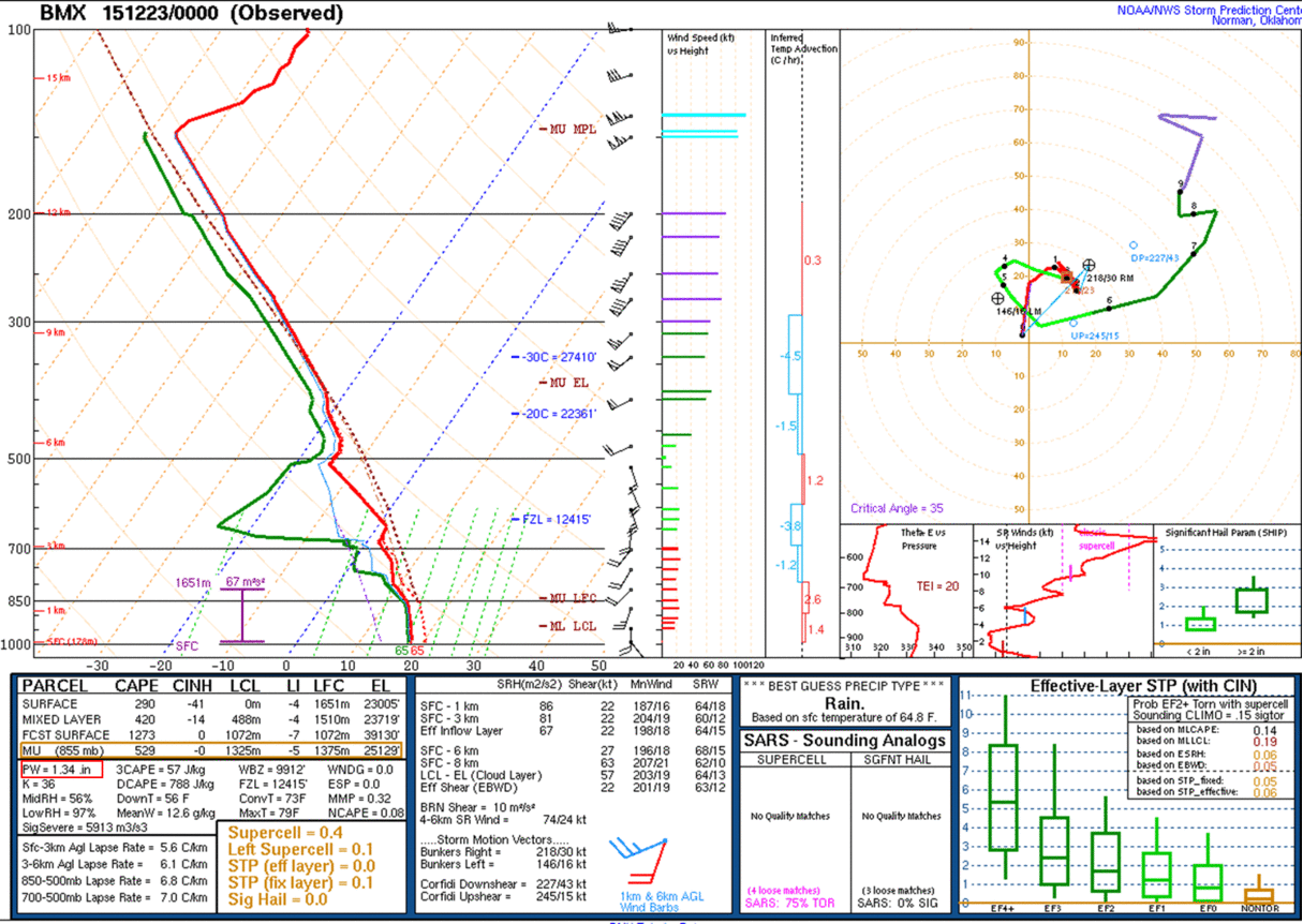
In addition, the advection of very warm and moist air via the subtropical jet across the Gulf of America and western Mexico allowed temperatures and a very saturated atmosphere to develop ahead of multiple fronts/disturbances. In fact, precipitable water values in the atmosphere from 12/21/2015 through 12/28/2015 are shown in the looped soundings below on the left. Many of these soundings indicate PW values of 1.3 to 1.7 inches were common during this period. The mean value of PW's from December 23 through December 28th typically ranges from around 0.50 inches to 0.60 inches. So this is a much more moist atmosphere than the typical mean. |
||||
|
||||
| Many of these fronts/disturbances (seen in surface analysis above on the right) moved across the Southeast U.S. and across the Tennessee and Ohio Valley regions. This produced multiple rounds of heavy rainfall across the Huntsville forecast area. The heaviest rainfall fell between December 25th and 26th, where most of northern Alabama and southern middle Tennessee received between 3 and 9 inches of rainfall (hardest hit were Marshall, Cullman, and Lawrence counties in Alabama). | ||||


 Local Radar
 Weather Map