
A storm system moving over the Rockies Wednesday will bring marginal risks for excessive rainfall and severe thunderstorms from parts of New Mexico into western South Dakota. Moderate snow is expected from northwestern Wyoming into southern Montana. Read More >
|
On September 1st, 2011 at 7 pm, Tropical Depression Lee developed in the central Gulf of America 225 miles southwest of the mouth of the Mississippi River. This tropical cyclone would later develop into a tropical storm as it pushed north and west toward the Louisiana coast from September 1st through September 3rd. The storm later dissipated as a extra-tropical low in extreme southwestern Mississippi on September 4th, 2011. The heavy rainfall, minor coastal surge, and tornadoes produced by this system ruined Labor Day Weekend for many along the Gulf Coast and in the southeastern US. Click the image on the left for an enlarged image of Lee's entire path. The image on the right shows Tropical Storm Lee around the time of its peak sustained wind speeds, which reached 60 mph at that time. |
||||
|
||||
Extremely heavy rainfall over the Gulf Coast - 09/01-04/2011)
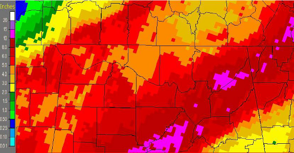
Tropical Storm Lee moved very slowly (less than 5 mph for much of its lifetime) north or northwestward from the central Gulf of America into the central Louisiana coast. It officially made landfall as a tropical storm with sustained winds of 45 mph and a central pressure of 986 mb about 7 miles southwest of the Pecan Island community. It then continued northward into extreme southwestern portions of Mississippi. This led to a prolonged period of very intense rainfall and minor coastal flooding along the Gulf Coast states. In fact, 10 to 15 inches of rain fell over portions of southeastern Louisiana, southern Mississippi, and the western Florida panhandle as a result. Below is an image of rainfall amounts produced through 7 am on September 5th over that areat. Some isolated amounts between 15 and 20 inches were reported in southeastern portions of Lousiana. Most of this fell through the midday hours on the 4th.
|
||||
|
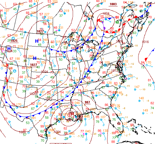
As it became extra-tropical during the early morning hours on September 4th, it started to be affected by an approaching cold front shown below. In addition to helping to weaken the storm it also caused the remnants of Lee to pick up speed slightly (only 6 to 8 mph) and steered it more to the northeast across the Tennessee Valley. Below is an image showing the relative positions of the cold front and Lee at 1 pm on September 3rd, 2011.
|
||||
Remnants of Lee Affect the Tennessee Valley (09/04-06/2011)
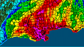
As the extratropical low was pulled up along the front beginning during the afternoon and evening hours on Sunday (September 4th), it still possessed some wind shear and very deep tropical moisture. This combination continued to produce very heavy rainfall along the front near and north of the center of the extra-tropical low. This front then pushed slowly east across the Tennessee Valley on Labor Day with heavy precipitation continuing through midnight. During this period, heavy rainfall produced flash flooding and flooding of some area creeks and streams across much of the Tennessee Valley. Big Wills Creek rose above flood stage and experienced some minor flooding beginning in the afternoon hours and continuing through the early morning hours on Tuesday, September 6th. As can be seen below, between 4 and 9 inches of rain fell across much of the Huntsville area, with amounts between 9 and 12 inches in some portions of northwestern and northeastern Alabama. The graphic depicts rainfall associated with Lee and its remnants through 7 am on September 6th. |
||||
Light to moderate rainfall continued as a secondary occluded low developed behind the front. Runoff from the earlier heavy rainfall and additional rainfall which lingered through the evening hours on the 6th also caused the Tennessee River at Florence to experience minor flooding beginning on the morning hours on September 7th. Click here for a link to the rainfall totals through 9 PM on September 6th.
|
||||


 Local Radar
 Weather Map