|
Showers and thunderstorms ahead of an approaching cold front and associated surface low brought rain and thunderstorms to the Tennessee Valley just before daybreak through the morning hours on the 25th. As the morning and early afternoon progressed, this activity pushed east into Georgia around 1 pm. This activity produced some heavier rainfall over much of northern Alabama, but no severe weather. As the afternoon progressed some surface heating occurred as the clouds thinned. As a result, instability increased in over northern Alabama. This can be seen in the surface analysis below, as surface temperatures climbed into the mid 60s. Marginal low level moisture was present with dewpoints in the mid to upper 50s. Locations south of the red line had dewpoints in the 50s, while the purple line depicts where dewpoints were above 60 degrees. |
||||||||
|
||||||||
|
At the same time, shear (a wind parameter needed for supercell and tornadic storm development) increased. This increase in shear aided by a 90 knot (103 mph) jet streak pushing east from eastern Texas and Lousiana at 500 mb (around 19,000 feet) and into northern Alabama along and ahead of the cold front. This wind maximum can be seen in the 500 mb analysis chart below, outlined in purple. |
||||||||
|
||||||||
|
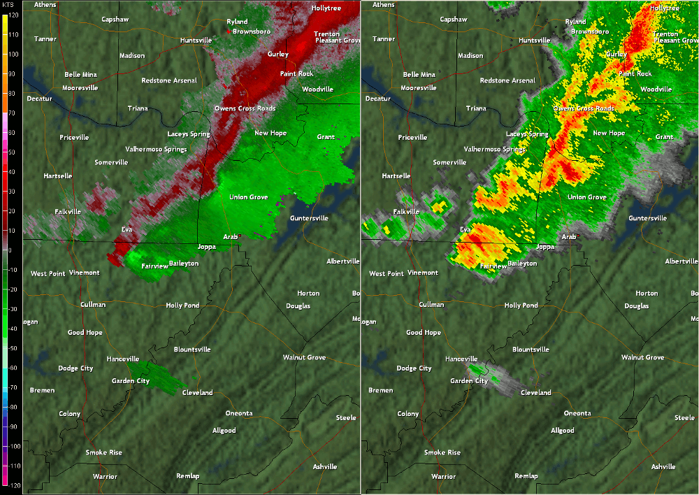
Shear through the late afternoon and early evening hours remained high enough for an isolated tornado threat. Wet-bulb temperatures were at an ideal level for large hail (between 7000 and 9000 feet) throughout the day and into the early evening hours. This set the stage for the development of severe thunderstorms producing large hail and isolated tornadoes. Below are loops of radar images around the time the tornado touched down in Morgan County. The loop on the left shows storm relative velocity between 5:35 pm and 5:58 pm. During this window, the tornado developed and moved across extreme southeastern portions of Morgan County, just northwest of the Joppa community. The image on the right is a base storm reflectivity product and shows precipitation. Click on the image to initiate a larger loop in a new window.
|
||||||||
|
Morgan County Tornado Survey Summary
|
||||||||
|
Below are some pictures of the damage along the path of this tornado.
|
||||||||
|
Damage Reports for Entire Severe Weather Event: |
||||||||
NWUS54 KHUN 270223
LSRHUN

PRELIMINARY LOCAL STORM REPORT...CORRECTED
NATIONAL WEATHER SERVICE HUNTSVILLE AL
923 PM CDT FRI MAR 26 2010

..TIME...   ...EVENT...      ...CITY LOCATION...     ...LAT.LON...
..DATE...   ....MAG....      ..COUNTY LOCATION..ST.. ...SOURCE....
            ..REMARKS..

0455 PM     HAIL             4 N FLORENCE            34.88N 87.68W
03/25/2010  E1.00 INCH       LAUDERDALE         AL   FIRE DEPT/RESCUE

            QUARTER SIZED HAIL IN THE OAK HILL SUBDIVISION NORTH OF
            FLORENCE. REPORTED BY FLORENCE FIRE DEPT.

0540 PM     TORNADO          8 W FALKVILLE           34.38N 87.05W
03/25/2010  F1               MORGAN             AL   NWS STORM SURVEY

            AN EF1 TORNADO TOUCHED DOWN JUST WEST OF MASSEY WITH A
            PATH LENGTH OF 3 MILES AND A MAXIMUM WIDTH OF 50 YARDS.
            MAXIMUM WINDS WERE ESTIMATED TO BE 100 MPH. A MOBILE HOME
            WAS SEVERELY DAMAGED AS WELL AS TWO CHICKEN HOUSES. TREES
            WERE ALSO SNAPPED.

0540 PM     TSTM WND DMG     8 W FALKVILLE           34.38N 87.05W
03/25/2010                   MORGAN             AL   FIRE DEPT/RESCUE

            POSSIBLE TORNADO. VOLNTEER FIRE DEPARTMENT REPORTED TREES
            AND POWERLINES DOWN ON SOUTH JOHNSON CHAPEL RD. NEAR
            MASSEY.

0610 PM     TSTM WND GST     S SOMERVILLE            34.47N 86.80W
03/25/2010  E45.00 MPH       MORGAN             AL   AMATEUR RADIO

            45-50 MPH WINDS AND PEA SIZE HAIL REPORTED SOUTH OF
            SOMERVILLE.

0612 PM     HAIL             BATTLEGROUND            34.30N 87.00W
03/25/2010  M1.00 INCH       CULLMAN            AL   TRAINED SPOTTER

            1.0 INCH HAIL REPORTED IN BATTLEGROUND.

0618 PM     HAIL             N WEST POINT            34.24N 86.96W
03/25/2010  M0.50 INCH       CULLMAN            AL   EMERGENCY MNGR

            DIME SIZE HAIL REPORTED NORTH OF WEST POINT.

0635 PM     FUNNEL CLOUD     5 W FAIRVIEW            34.25N 86.77W
03/25/2010                   CULLMAN            AL   NWS STORM SURVEY

            FUNNEL CLOUD REPORTED 5 MILES WEST OF FAIRVIEW. NO DAMAGE
            FOUND ON NWS STORM SURVEY.


&&

$$

KNS
|
||||||||


 Local Radar
 Weather Map